10 p.m. Update from the Hurricane Center: Milton Still Category 5
LATEST INFORMATION ON HURRICANE MILTON
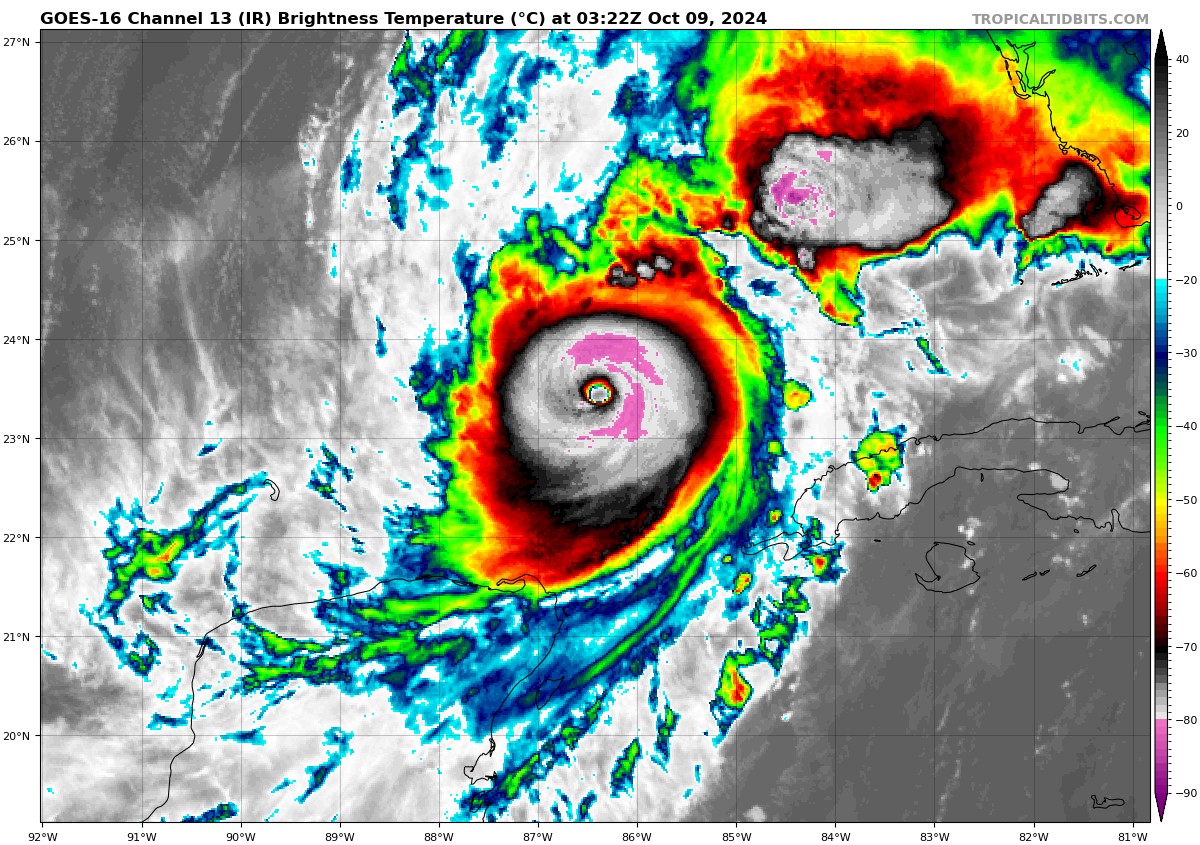
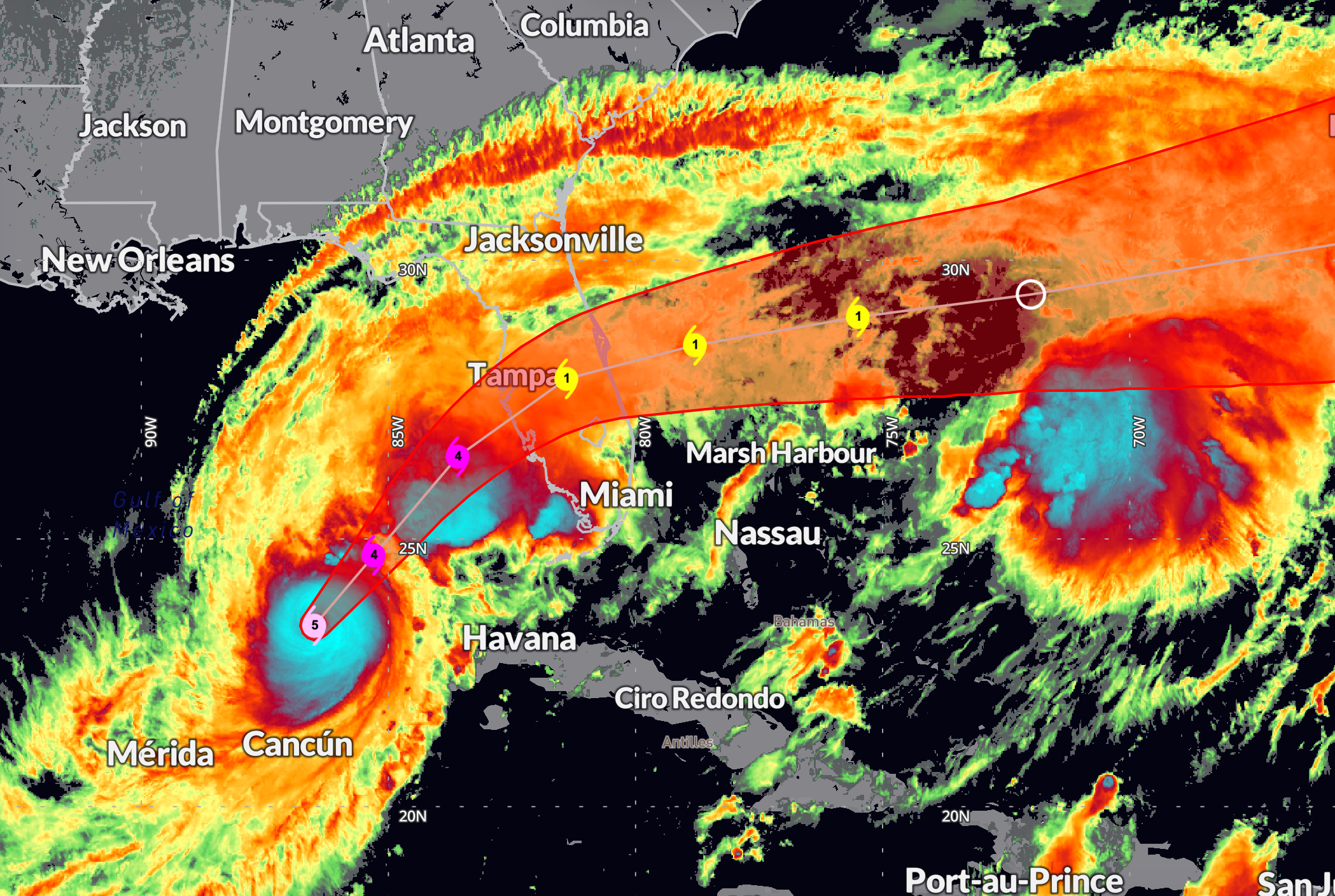
As of 10:00 PM CDT, Hurricane Milton remains an extremely dangerous Category 5 storm with maximum sustained winds of 160 mph and a central pressure of 915 mb. Located at 23.4N, 86.5W, roughly 245 miles west-southwest of the Dry Tortugas and 405 miles southwest of Tampa, Florida, Milton is moving northeast at 12 mph. The hurricane is expected to maintain major strength across the Gulf of Mexico, reaching the Florida Gulf Coast late Wednesday. As Milton begins to interact with a trough over the eastern United States, it may begin an extratropical transition, which could expand its size and energy, potentially slowing any weakening before landfall. This interaction with the trough could also increase the extent of hurricane-force winds on the storm’s northwest side, making it even more impactful along the coast.
FORECAST TRACK AND TIMING
Milton is forecast to continue its northeastward track overnight, with a slight increase in forward speed through Wednesday. It is expected to make landfall along Florida’s west-central coast late Wednesday night before turning east-northeastward over the Atlantic by Thursday. The exact landfall location is still uncertain but will likely be somewhere between Clearwater and Sarasota. Minor shifts in track could result in significant changes to impacts in local areas, particularly regarding wind and storm surge.
STORM SURGE IMPACTS
A life-threatening storm surge of 10 to 15 feet is expected along the Florida west coast, particularly from Egmont Key to Boca Grande and including Tampa Bay. Additional areas from Boca Grande to Bonita Beach, including Charlotte Harbor, are forecast to see surge heights of 8 to 12 feet. Surge-related flooding could extend up the coast from Sebastian Inlet, FL, to Edisto Beach, SC, with levels reaching 2 to 5 feet. This is an extremely dangerous situation for those within the Storm Surge Warning area, who should evacuate immediately as instructed by local officials. The timing of peak surge is expected to coincide with high tide, increasing the risk for coastal areas.
Here are peak surges from the NHC…
Egmont Key, FL to Boca Grande, FL…10-15 ft
Tampa Bay…10-15 ft
Anclote River, FL to Egmont Key, FL…9-13 ft
Boca Grande, FL to Bonita Beach, FL…8-12 ft
Charlotte Harbor…8-12 ft
Bonita Beach, FL to Chokoloskee, FL…5-8 ft
Aripeka, FL to Anclote River, FL…5-8 ft
Chokoloskee, FL to Flamingo, FL…3-5 ft
Sebastian Inlet, FL to Altamaha Sound, GA…3-5 ft
Altamaha Sound, GA to Edisto Beach, SC…2-4 ft
Suwannee River, FL to Aripeka, FL…2-4 ft
Dry Tortugas…2-4 ft
St. Johns River…2-4 ft
WIND IMPACTS
Hurricane-force winds are expected to begin impacting the Florida west coast late Wednesday and will spread across the peninsula overnight. Areas along and north of the storm’s landfall point could see the strongest winds, with gusts exceeding 160 mph along the immediate coast. Inland regions, including the I-4 corridor, will experience tropical storm conditions with gusts reaching 100 mph. Tropical storm-force winds are expected to extend well beyond the center, affecting the northwest Bahamas by Thursday. Residents should prepare for long-duration power outages and significant wind damage.
RAINFALL IMPACTS
Rainfall amounts of 6 to 12 inches, with localized totals up to 18 inches, are forecast for central and northern portions of the Florida Peninsula through Thursday. This heavy rainfall will lead to a heightened risk of catastrophic flash flooding, urban flooding, and river flooding. Coastal areas may experience a combination of storm surge and inland flood impacts, intensifying the threat across the region.
TORNADOES AND SURF
A few tornadoes are possible across central and southern Florida through Thursday night. Life-threatening surf and rip currents will affect much of the Gulf Coast over the coming days as well. Residents should avoid beaches and follow local advisories.
URGENT EVACUATION ADVICE
Residents in evacuation zones, particularly within the Storm Surge Warning areas, must act immediately to evacuate. Delay could result in deadly outcomes, especially as the peak surge may coincide with high tide. If you are in a mobile home or temporary structure, seek more substantial shelter without delay.
IN CLOSING
Hurricane Milton is one of the most dangerous hurricanes to threaten west-central Florida in recent history. The storm’s destructive surge, extreme wind impacts, and catastrophic inland flooding potential mean that all preparations should be completed tonight. Follow all local evacuation orders and take the necessary actions to protect life and property.
Category: ALL POSTS, Social Media, Tropical
About the Author (Author Profile)
Bill Murray is the President of The Weather Factory. He is the site's official weather historian and a weekend forecaster. He also anchors the site's severe weather coverage. Bill Murray is the proud holder of National Weather Association Digital Seal #0001 @wxhistorianSubscribe
If you enjoyed this article, subscribe to receive more just like it.


