
4pm CDT Update: Milton Once Again a Category 5 Storm; Max Winds at 165 mph and Pressure at 918 mb
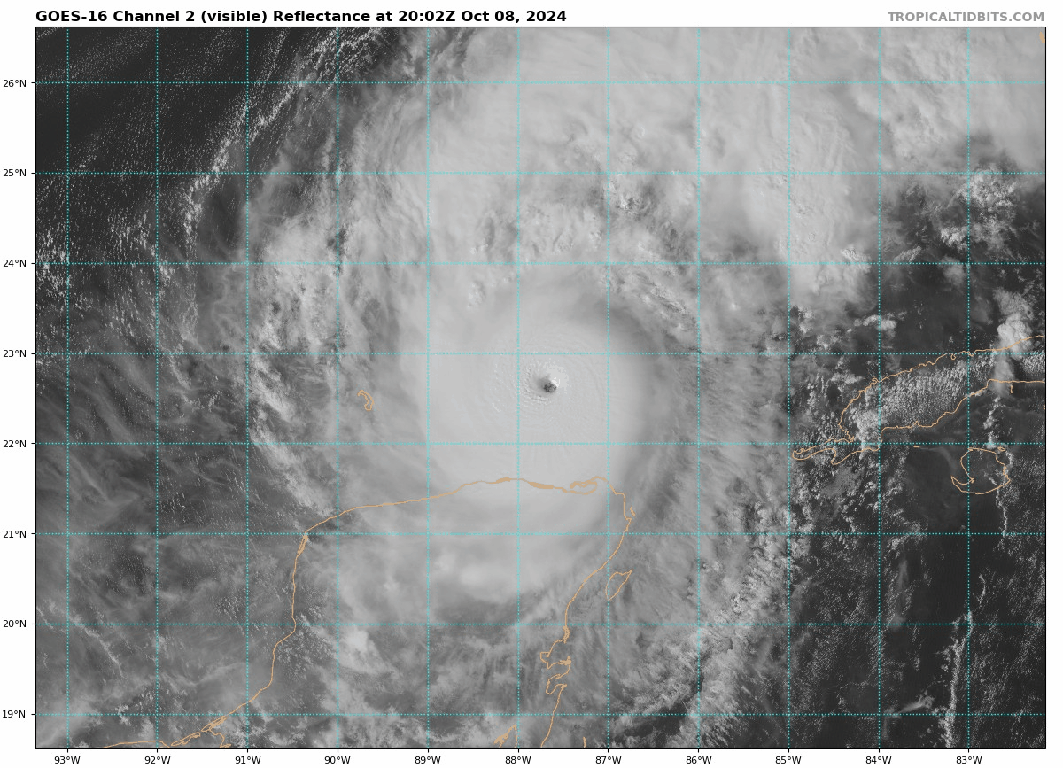
The hurricane hunters have found falling pressure as they flew through the eye of Milton. This storm has become much more organized as the day has gone on. The eye is nearly 10 miles wide. If we get updated readings from the dropsondes, we will pass your way!
If you have friends and family under any advisory in Florida please check on them. Noone should be staying along the coast in Milton’s path. If they have been asked to evacuate they need to leave. Everyone else needs to finish getting their homes ready for Milton to come through and complete their hurricane checklist.
Stats
LOCATION…22.7N 87.5W
ABOUT 320 MI…520 KM WSW OF THE DRY TORTUGAS
ABOUT 480 MI…775 KM SW OF TAMPA FLORIDA
MAXIMUM SUSTAINED WINDS…165 MPH…270 KM/H
PRESENT MOVEMENT…ENE OR 75 DEGREES AT 9 MPH…15 KM/H
MINIMUM CENTRAL PRESSURE…918 MB…27.11 INCHES
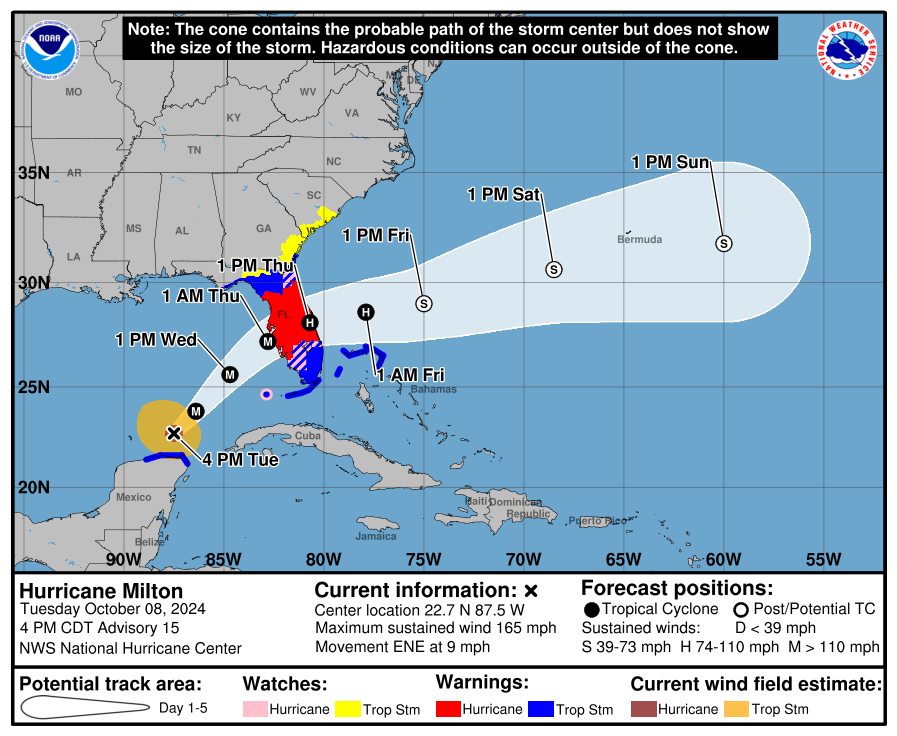
Changes in Watches and Warnings with this Advisory:
The Storm Surge Warning along the U.S. east coast has been extended
southward to Sebastian Inlet, Florida, and northward to Altamaha
Sound, Georgia.
The Hurricane Warning along the east coast of Florida has been
extended southward to the St. Lucie/Martin County Line.
The Tropical Storm Warning along the U.S. east coast has been
extended northward to Altamaha Sound, Georgia.
A Hurricane Watch has been issued for the Florida east coast from
the St. Lucie/Martin County Line to the Palm Beach/Martin County
Line.
The government of the Bahamas has issued a Tropical Storm Warning
for the extreme northwestern Bahamas, including Grand Bahama Island,
the Abacos, and Bimini.
The government of Mexico has discontinued the Hurricane Warning from
Celestun to west of Dzilam, has changed the Hurricane Warning from
Dzilam to Rio Lagartos to a Tropical Storm Warning, and has
discontinued the Hurricane Watch from Rio Lagartos to Cabo Catoche.
A review of the official discussion:
Milton jogged a bit to the southeast today. From the discussion, “Because of the wobble, the track guidance has been initialized a bit to the south of where many of the raw model fields think the hurricane was centered at 1800 UTC, and this has caused the entire guidance envelope to shift a bit south on this cycle.”
A reminder to those (e.g. myself) who watched 12Z regional dynamical models go north of #Tampa, only to see 12Z global models + 18Z early models south of Tampa. 42 hour avg track error is ~60 miles, the distance between Siesta Key + Clearwater. We have to prepare + wait. #Milton pic.twitter.com/VgjQS75Sdn
— Kieran Bhatia (@BhatiaKieran) October 8, 2024
That post by Kieran is very telling. There is still a good deal of uncertainty on where Milton will be making landfall and that is important to determine worse surge and wind. And with the storm wobbling, that makes this even more difficult.
The forecast is for Milton to start to run into shear in about 24 hours. At that point a decrease in max winds is forecast but will still be a major hurricane at landfall. It is unclear at this point how strong Milton will get before it hits shear and how much the winds will decrease before landfall. The hurricane hunters will continue to fly into the storm getting valuable readings.
Milton’s wind field is growing some and that will continue. Hurricane force winds are out 30 miles from the center and tropical storm force winds out 140 miles. That is expected to double on the approach to Florida!
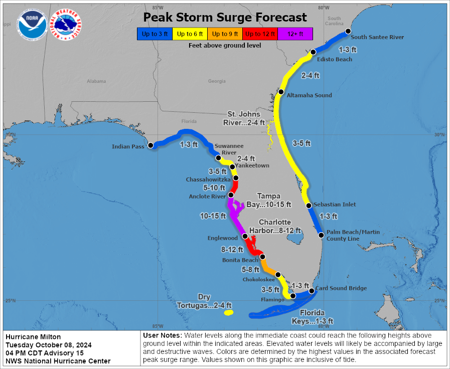
It doesn’t matter at this point how much Milton “weakens” – the surge is going to bad. A large area of 10 feet or greater surge is forecast for a portion of west central Florida coast. This is life-threatening and people have to evacuate.
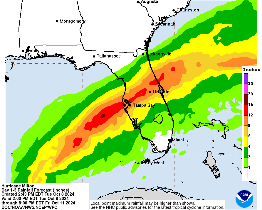
Devastating rain amounts are forecast with locally up to 15-18 inches possible.
Category: ALL POSTS, Social Media, Tropical
About the Author (Author Profile)
Owner of Tornado Talk. Radio broadcast meteorologist with The Storm Report. WeatherBrains Panelist. B.S. Meteorology from Penn State University.Subscribe
If you enjoyed this article, subscribe to receive more just like it.


