Midday Nowcast: Terrific Tuesday for Alabama; Milton Strengthens Some

Plenty of sunshine in the Alabama sky today, and since that front moved through last night, a drier and cooler air mass is settling into the state. Highs this afternoon are in the low to mid 80s. Tonight will be clear and refreshing with lows in low 50s to low 60s across Alabama.
BIRMINGHAM ALMANAC: For October 8th, the average high for Birmingham is 79° and the average low is 57°. The record high is 91° set in 1897, while the record low is 34° set in 1991. We average 0.10” of precipitation on this date, and the record value is 3.55” set in 1977.
REST OF WEEK: We expect sunny days and fair cool nights the rest of this week and through the weekend. Highs will be in the upper 70s and low 80s, with lows in the 50s. Some of the colder pockets across North Alabama could reach the 40s early Friday morning. This is a very dry air mass, meaning no humidity, and no rain as a long dry spell settles into Alabama.
WEEKEND AND BEYOND: The pattern doesn’t change as we roll into the weekend and next week. It is a dry forecast for the Deep South with sunny pleasant days and clear cool nights. Highs will be mostly in the upper 70s and low 80s, with lows in the 50s over the northern and central counties. Even cooler air arrives next week; highs drop into the 60s with lows in the 40s over the northern 2/3 of the state by Tuesday and Wednesday. And, still no sign of any meaningful rain for Alabama for at least the next 7-10 days.

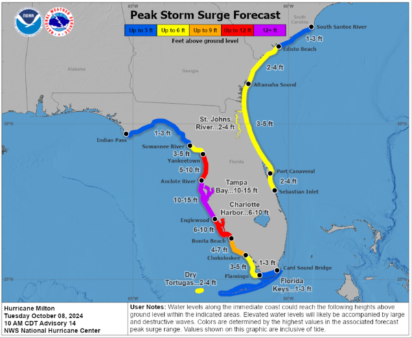
HURRICANE MILTON: Milton went through an eye wall replacement cycle last night, which caused it to weaken some, but this will be a life-threatening and devastating storm for the state of Florida, with record storm surges along the west coast of Florida.
Latest update from the National Hurricane Center had the center of Hurricane Milton was located near latitude 22.7 North, longitude 88.4 West. Milton is moving toward the east-northeast near 9 mph. A turn toward the northeast with an increase in forward speed is expected to begin later today and continue through Thursday. On the forecast track, the center of Milton will move across the eastern Gulf of Mexico and approach the west-central coast of Florida through Wednesday. The center is likely to make landfall along the west-central coast of Florida on Wednesday night, and move east-northeastward across central Florida through Thursday.
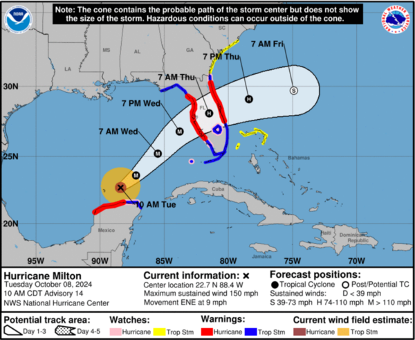
Maximum sustained winds are near 150 mph with higher gusts. Milton is a category 4 hurricane on the Saffir-Simpson Hurricane Wind Scale. While fluctuations in intensity are expected, Milton is forecast to remain an extremely dangerous hurricane through landfall in Florida. Hurricane-force winds extend outward up to 30 miles from the center and tropical-storm-force winds extend outward up to 105 miles. The minimum central pressure based on dropsonde data is 929 mb (27.44 inches).
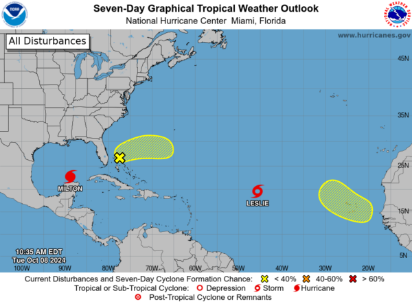
REST OF THE TROPICS: Leslie has weakened into a tropical storm and will remain a fish storm. Two other areas the NHC is monitoring, but over the next seven days, both have a low chance of development.
WORLD TEMPERATURE EXTREMES: Over the last 24 hours, the highest observation outside the U.S. was 115.7F at Ejido Nuevo León, Mexico. The lowest observation was -85.4F at Vostok, Antarctica.
CONTIGUOUS TEMPERATURE EXTREMES: Over the last 24 hours, the highest observation was 115F at Glamis, CA. The lowest observation was 18F at Calpet, WY.
Category: Alabama's Weather, ALL POSTS, Social Media
About the Author (Author Profile)
Macon, Georgia Television Chief Meteorologist, Birmingham native, and long time Contributor on AlabamaWX. Stormchaser. I did not choose Weather, it chose Me. College Football Fanatic. @Ryan_StinnetSubscribe
If you enjoyed this article, subscribe to receive more just like it.


