10am CDT Milton Update: Last Full Day For Preparations; Winds Up To 150 mph
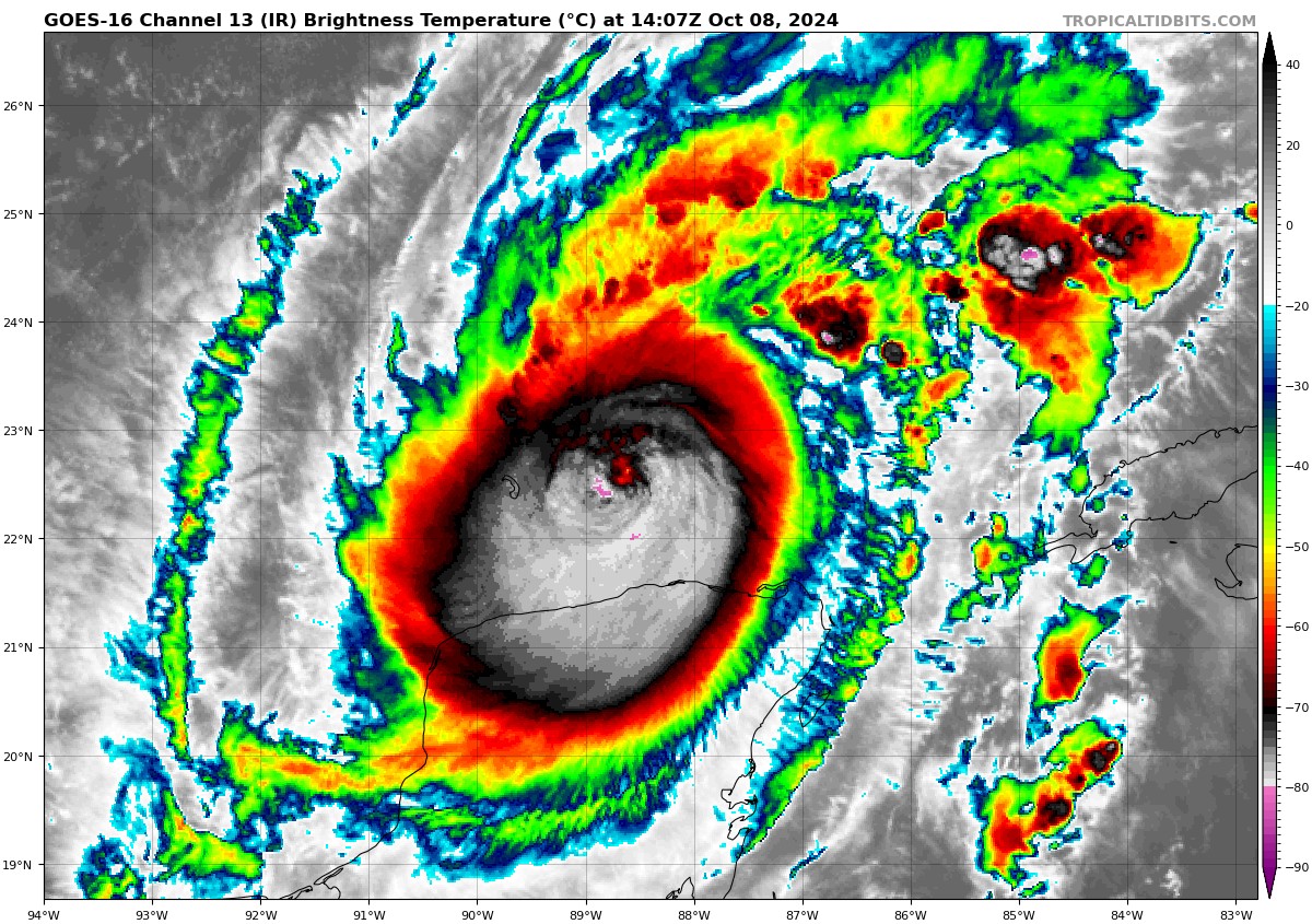
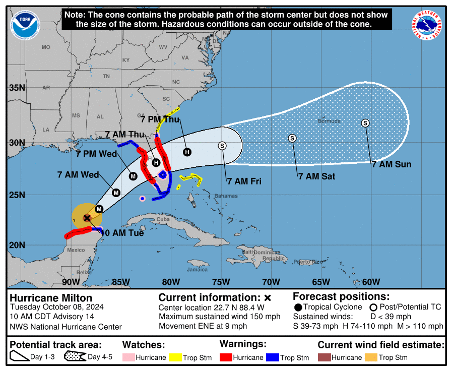
Milton has strengthened slightly over the past couple of hours, with winds now at 150 mph. The pressure remains at 929 mb. Landfall is expected to occur near Tampa Bay on Wednesday night.
Here is the latest from the NHC:
SUMMARY OF 1000 AM CDT…1500 UTC…INFORMATION
———————————————–
LOCATION…22.7N 88.4W
ABOUT 130 MI…205 KM NE OF PROGRESO MEXICO
ABOUT 520 MI…835 KM SW OF TAMPA FLORIDA
MAXIMUM SUSTAINED WINDS…150 MPH…240 KM/H
PRESENT MOVEMENT…ENE OR 65 DEGREES AT 9 MPH…15 KM/H
MINIMUM CENTRAL PRESSURE…929 MB…27.44 INCHES
SUMMARY OF WATCHES AND WARNINGS IN EFFECT:
A Storm Surge Warning is in effect for…
* West coast of Florida from Flamingo northward to the Suwannee
River, including Charlotte Harbor and Tampa Bay
* East coast of Florida from Port Canaveral northward to the mouth
of the St. Mary’s River, including the St. Johns River.
A Hurricane Warning is in effect for…
* Celestun to Rio Lagartos
* Florida west coast from Bonita Beach northward to the mouth of the
Suwannee River, including Tampa Bay
* Florida east coast from the Indian River/St. Lucie County Line
northward to Ponte Vedra Beach
A Storm Surge Watch is in effect for…
* South of Port Canaveral to Sebastian Inlet
* Mouth of the St. Mary’s River to Edisto Beach
A Hurricane Watch is in effect for…
* Rio Lagartos to Cabo Catoche
* Dry Tortugas
* Lake Okeechobee
* Florida west coast from Chokoloskee to south of Bonita Beach
* Florida east coast north of Ponte Vedra Beach to the mouth of the
St. Mary’s River
A Tropical Storm Warning is in effect for…
* Rio Lagartos to Cancun
* All of the Florida Keys, including Dry Tortugas and Florida Bay
* Lake Okeechobee
* Florida west coast from Flamingo to south of Bonita Beach
* Florida west coast from north of the mouth of the Suwanee River to
Indian Pass
* Florida east coast south of the Indian River/St. Lucie County
Line to Flamingo
* Florida east coast north of Ponte Vedra Beach to the mouth of the
St. Mary’s River
A Tropical Storm Watch is in effect for…
* Coast of Georgia and South Carolina from north of the mouth of the
St. Marys River to South Santee River, South Carolina
* Extreme northwestern Bahamas, including Grand Bahama Island,
the Abacos, and Bimini.
An important reminder about hurricanes is that it is important to not get caught up on what category a storm is. A major hurricane (categories 3,4,5) has the potential to cause devastating damage and pose life-threatening risks regardless of its category. This is exactly the case with Milton. We cannot pinpoint exactly what category it will be at landfall just yet (although there is increasing confidence it was be a category 3 hurricane), but we do know that it will be a major hurricane that brings catastrophic impacts to Florida.
Milton underwent an eyewall replacement cycle overnight, meaning it formed a new eyewall. This allowed the storm to reduce the size of the eye, and therefore increase wind speeds within the eyewall. This will also allow the entire storm to grow in size.
The NHC notes that the wind field of Milton is expected to double in size by the time it reaches the Florida Coast. This would bring devastating wind damage to much of the western Florida Coast. Tropical storm force winds are expected to reach the Florida Coast tomorrow morning, ahead of Milton’s landfall.
From the NHC: It is worth emphasizing that this is a very serious situation and residents in Florida should closely follow orders from their local emergency management officials. Evacuations and other preparations should be completed today. Milton has the potential to be one of the most destructive hurricanes on record for west-central Florida.
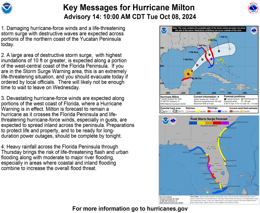
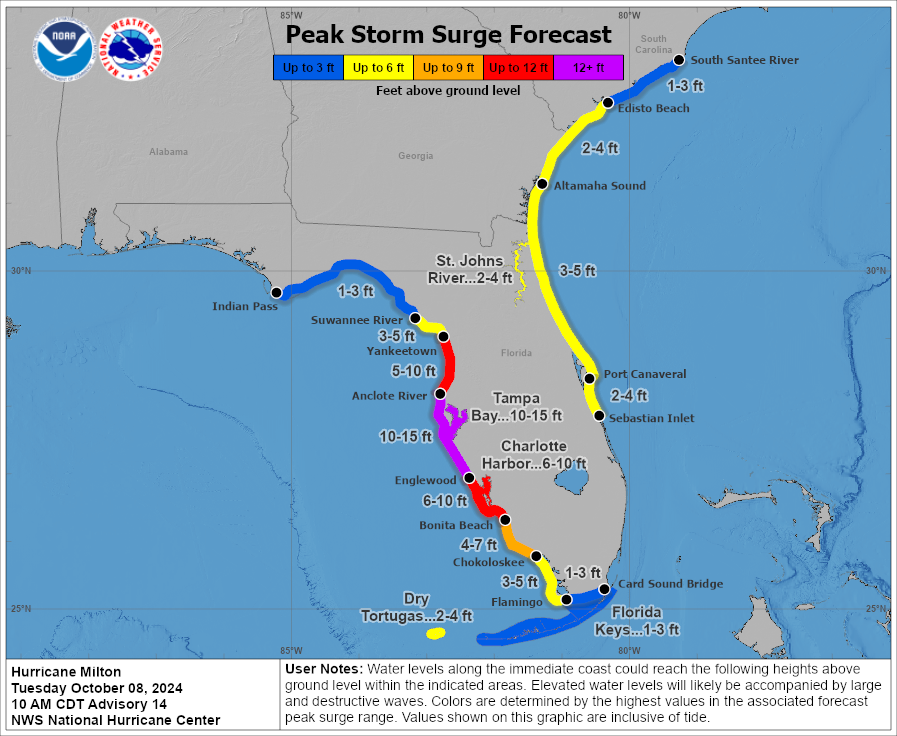
The storm surge that will come with Milton will be destructive and potentially deadly. Areas from Anclote River to Englewood, including Tamp Bay, are forecast to receive 10-15 ft of surge. Other areas along the Florida and South Carolina could see surge amounts of 1-10 ft, depending on proximity to the landfall location. Remember, surge can affect areas well inland. All of Central Florida should be prepared for this potentially catastrophic surge to occur.
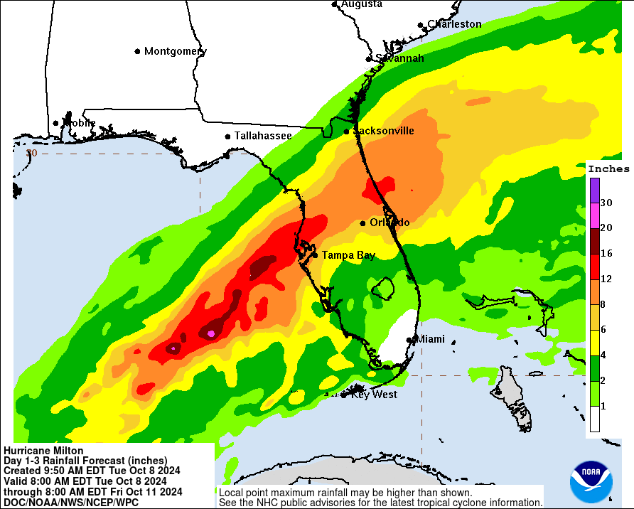
Milton will bring lots of rainfall to Central Florida, with places north of Tampa Bay and Orlando potentially seeing up to 15 inches of rain. The rest of the state could see anywhere between 1-12 inches of rain. This rain is going to occur very rapidly, and will supplement rain that has already been falling in Florida today and yesterday. This, combined with storm surge, could lead to a flooding disaster in many parts of the state.
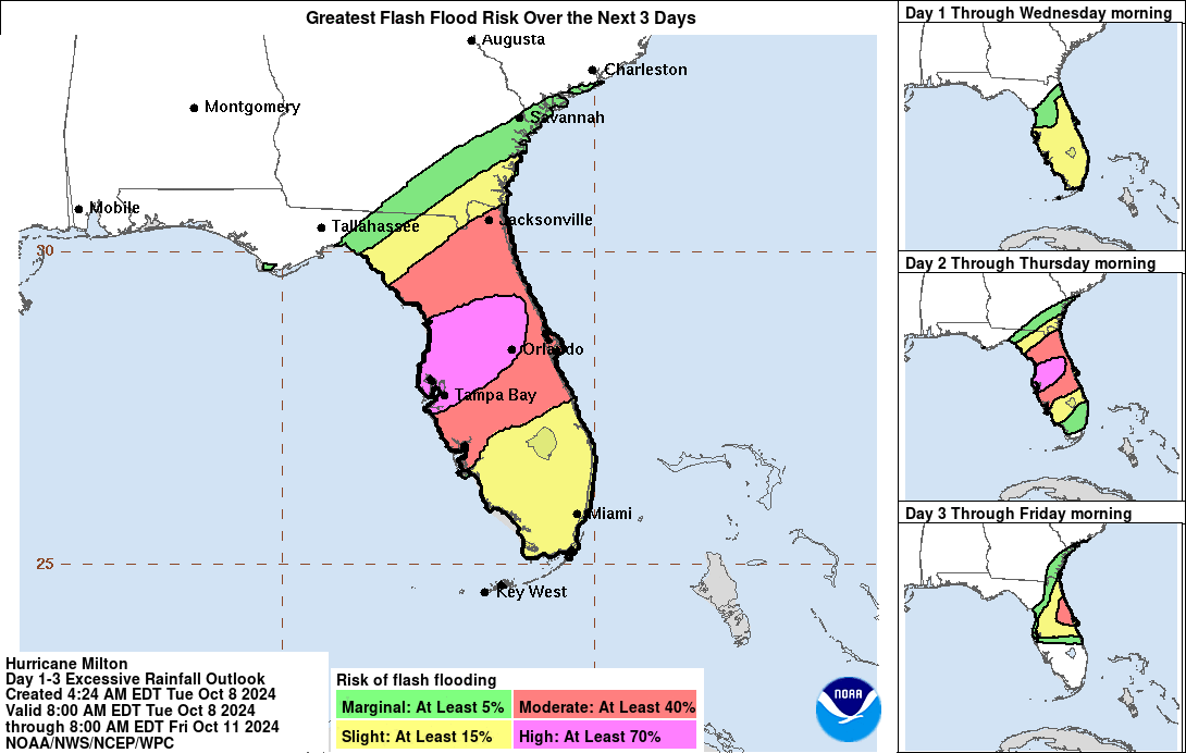
With the amount of rainfall expected, flash flooding across most of Florida is expected to occur. Central Florida has the highest risk, with a 70% chance of flash flooding. Flash floods can occur at anytime after rain has begun, so please be aware when driving through flooded areas.
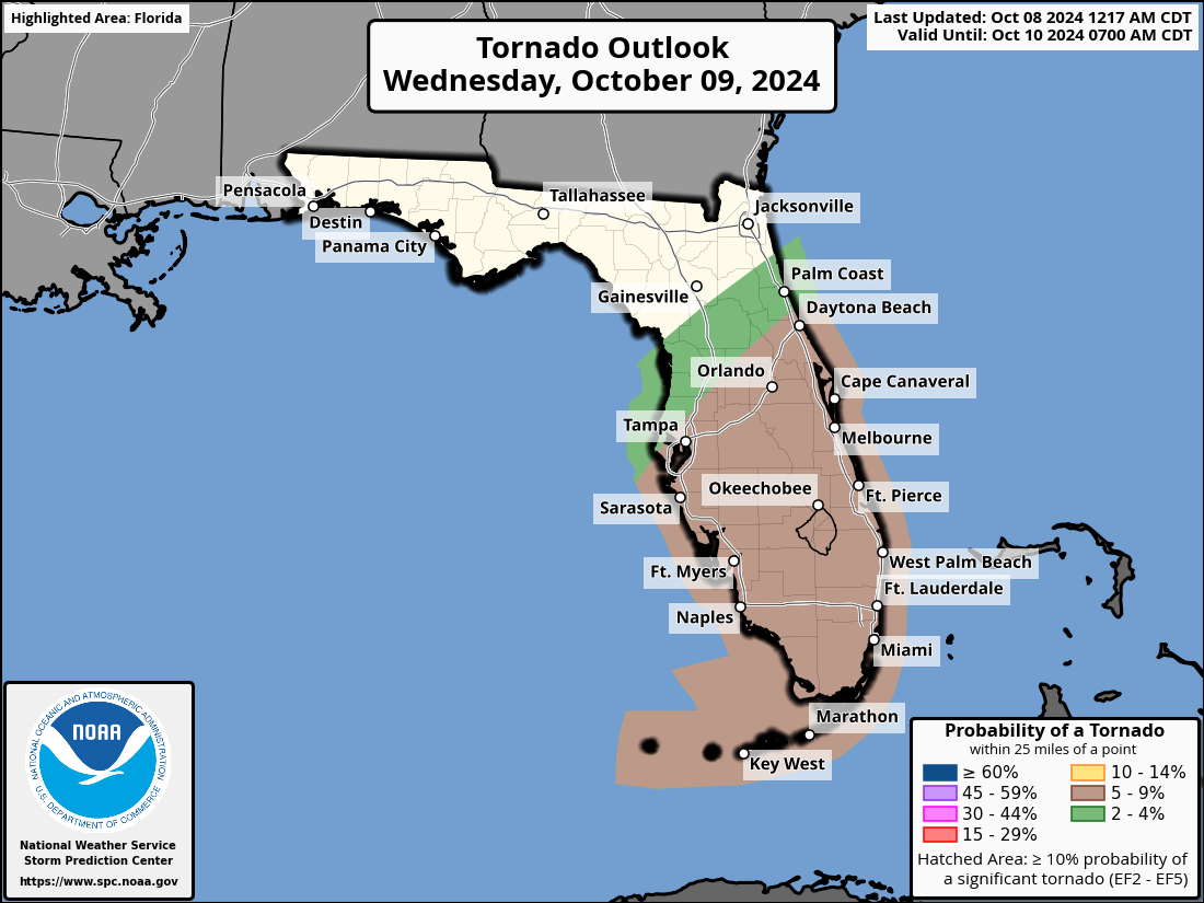
Lastly, there is a chance that Milton will bring along some tornados. If so, they will likely be embedded within the outer rain bands of the storm, so be prepared once they start to make their way across the state.
We will continue to keep you updated throughout the coming days.
Category: ALL POSTS, Social Media, Tropical
About the Author (Author Profile)
Scott is a senior at Mississippi State University studying professional and broadcast meteorology.Subscribe
If you enjoyed this article, subscribe to receive more just like it.


