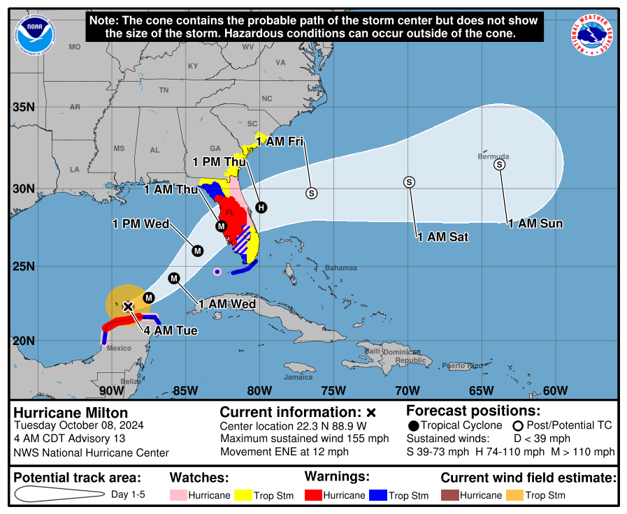
4am CDT Milton Update: This Dangerous Storm Just North of the Yucatan Peninsula; Approaches the Florida Peninsula on Wednesday
Good morning. We have the latest update from the NHC on Major Hurricane Milton. It will be another day of monitoring the storm as it begins to lift away from the Yucatan area. The structure of the system is changing. It is still very powerful and is forecast to be that way through landfall. The tropical storm and hurricane force winds are forecast to roughly double in size which will bring in more widespread concerns of wind, surge and heavy rain to more areas. One of the biggest risks for our friends in Florida is the surge. If you have been asked to leave by your local officials, please leave. Further inland, today is the day to complete your hurricane preparations and make sure you have the supplies needed. Based on the latest guidance, a landfall is expected Wednesday night but impacts will begin earlier in the day with the arrival of tropical storm force-winds, some heavy rain bands and the risk of tornadoes.
SUMMARY OF 400 AM CDT…0900 UTC…INFORMATION
———————————————-
LOCATION…22.3N 88.9W
ABOUT 85 MI…140 KM NE OF PROGRESO MEXICO
ABOUT 560 MI…905 KM SW OF TAMPA FLORIDA
MAXIMUM SUSTAINED WINDS…155 MPH…250 KM/H
PRESENT MOVEMENT…ENE OR 75 DEGREES AT 12 MPH…19 KM/H
MINIMUM CENTRAL PRESSURE…924 MB…27.29 INCHES
WATCHES AND WARNINGS
——————–
CHANGES WITH THIS ADVISORY:
None.
SUMMARY OF WATCHES AND WARNINGS IN EFFECT:
A Storm Surge Warning is in effect for…
* West coast of Florida from Flamingo northward to the Suwannee
River, including Charlotte Harbor and Tampa Bay
A Hurricane Warning is in effect for…
* Celestun to Rio Lagartos
* Florida west coast from Bonita Beach northward to the mouth of the
Suwannee River, including Tampa Bay
A Storm Surge Watch is in effect for…
* Sebastian Inlet to Edisto Beach, including St. Johns River
A Hurricane Watch is in effect for…
* Rio Lagartos to Cabo Catoche
* Campeche to south of Celestun
* Dry Tortugas
* Lake Okeechobee
* Florida west coast from Chokoloskee to south of Bonita Beach
* Florida east coast from the St. Lucie/Indian River County Line
northward to the mouth of the St. Marys River
A Tropical Storm Warning is in effect for…
* Rio Lagartos to Cancun
* Campeche to south of Celestun
* All of the Florida Keys, including Dry Tortugas
* Lake Okeechobee
* Florida west coast from Flamingo to south of Bonita Beach
* Florida west coast from north of the mouth of the Suwanee River to
Indian Pass
A Tropical Storm Watch is in effect for…
* East coast of the Florida Peninsula south of the St. Lucie/Indian
River County Line southward to Flamingo
* Coast of Georgia and South Carolina from north of the mouth of the
St. Marys River to South Santee River, South Carolina
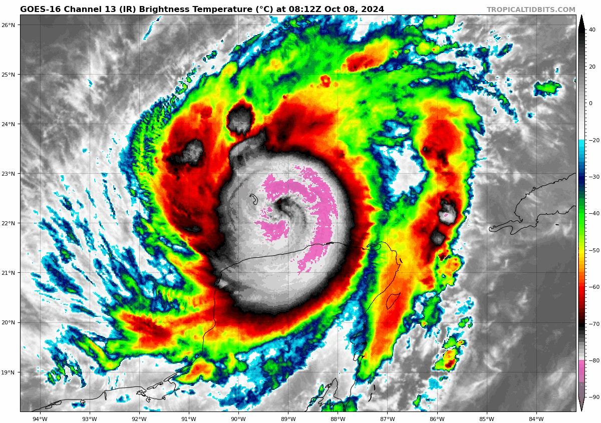
The NHC discussion denotes that Milton has gone through an eyewall replacement cycle. This happens with large systems and causes fluctuations in intensity and we begin to see them grow in size. Thus far, Milton has been a very compact system but that is forecast to change. The NOAA and Air Force Hurricane Hunters will be investigating the system starting this morning to give more information on Milton.
Milton is moving to the ENE and is forecast to begin more of an NE turn and pick up the pace. We are looking at the storm’s center coming into west-central Florida Wednesday night.
Max winds at the center of Milton are at 155 mph. Fluctuations in the winds are going to occur. There are a lot of factors that go into how storms of this magnitude maintain or lose strength. Eye replacement cycles are one way storms can see a decrease in max winds. Over the next 24 hours, the environment for Milton is still conducive for maintaining strength or it could even see an uptick in the core winds. There is still forecast a more significantly sheared environment to form and Milton will run into that on its approach to the west coast of Florida. That is another way storms can start seeing an easing of the core winds. It also means the overall windfield can grow in size and as I mentioned Milton’s windfield is expected to do that.
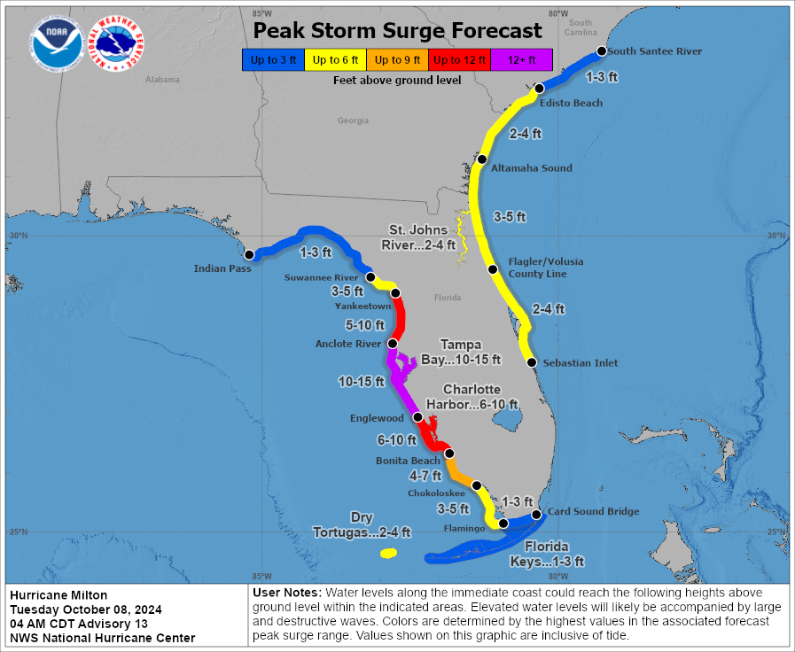
Regardless of category, we are going to have a growing, major hurricane heading toward the west coast of Florida at an angle where all of the Gulf water with it will get pushed onto the coast. Yes, a decrease in core winds would help with wind impacts but not the surge. Here is the latest peak surge map. This shows how high the water could be when it is pushed in by the storm along with high tide. There will be large waves on top of this, a devastating scenario along the west coast of Florida. Notice too, there will be surge impacts along the east coast of Florida AND the southeast US coast!
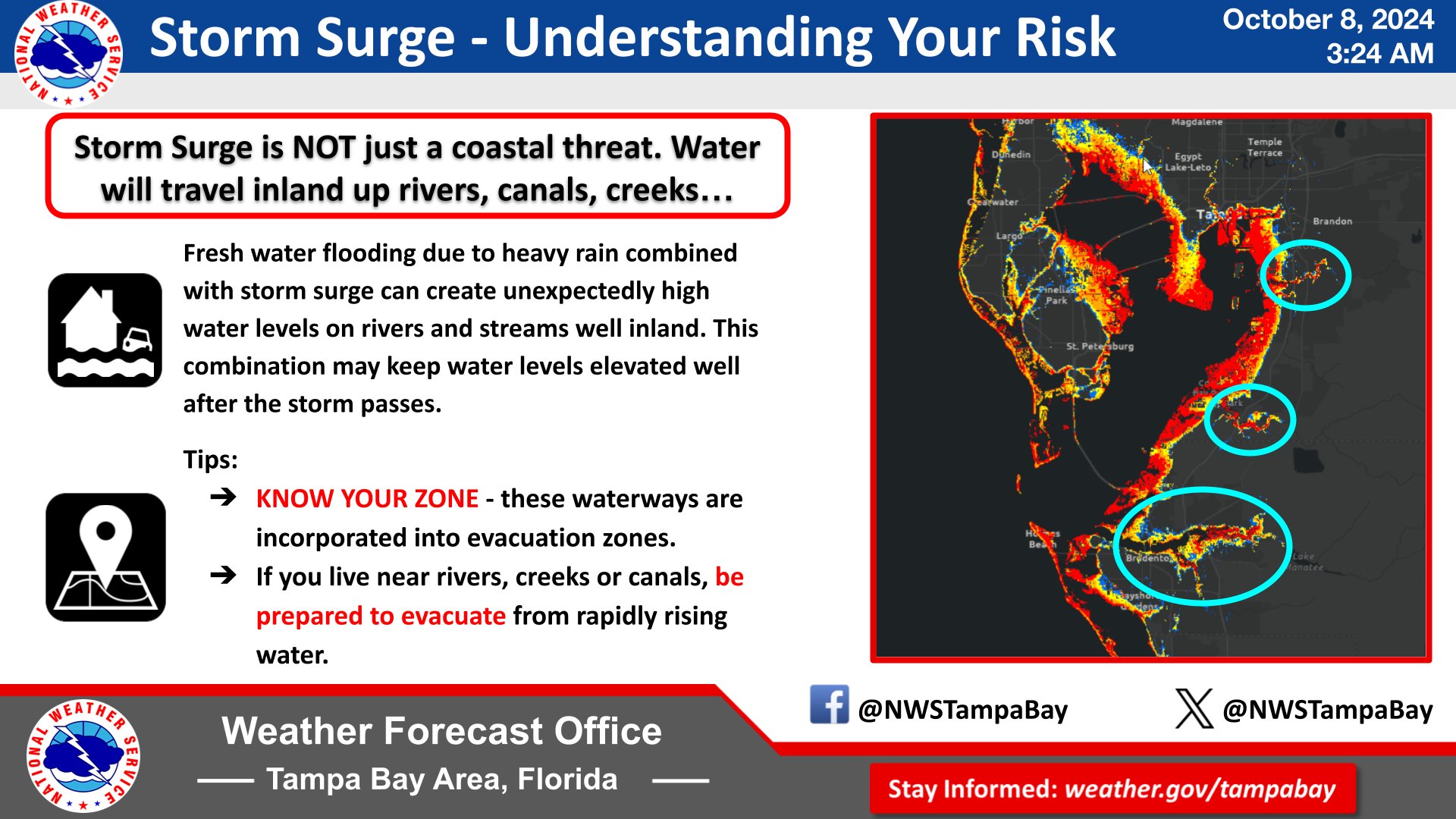
Here is a great graphic from the NWS Tampa Bay. Surge is not only a coastal threat. Water will travel inland up rivers, canals, creeks, etc.
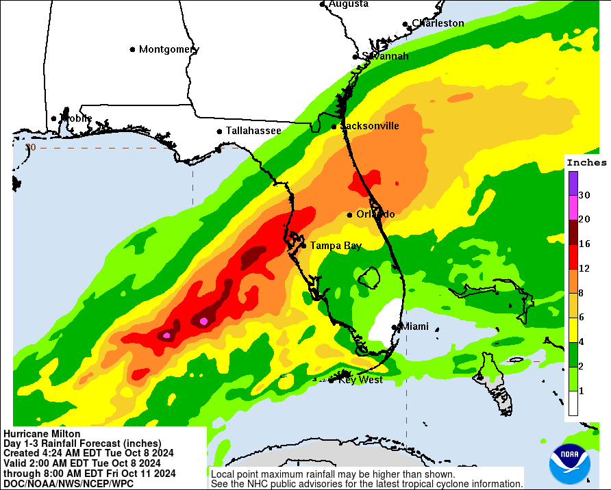
Here is the latest rainfall graphic. There could be over a foot, locally up to 15-18 inches of rain coming in from Milton. Notice, the heavy rain is not just for the west coast but for parts of Central Florida and toward the Atlantic coast as well.
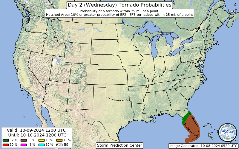
Last item: Here is a look at the tornado threat from the SPC for Wednesday. There is an isolated tornado threat as well for parts of the Florida peninsula today as well.
We will have updates through the entirety of this event. If you find these help, please share with others to help get the word out on this very dangerous weather situation. You can follow all of our updates as well on our X account.
Category: ALL POSTS, Social Media, Tropical
About the Author (Author Profile)
Owner of Tornado Talk. Radio broadcast meteorologist with The Storm Report. WeatherBrains Panelist. B.S. Meteorology from Penn State University.Subscribe
If you enjoyed this article, subscribe to receive more just like it.


