10PM CDT Hurricane Milton Update: Winds Now at 165 mph; Devastating Impacts to Florida Expected
From a scientific perspective, Hurricane Milton has been a fascinating system to watch. However, it is an extremely dangerous storm that should be taken seriously by those who are located in the expected impact areas. Milton remains a category 5 hurricane, although fluctuations in intensity may occur over the coming days. Regardless, this storm will bring devastating surge to the Florida Coast, especially to areas near Tampa Bay. Wind damage is also a large concern, as intense hurricane-force winds are expected to impact Tampa Bay and surrounding areas.
Here are the latest stats from the NHC:
SUMMARY OF 1000 PM CDT…0300 UTC…INFORMATION
———————————————–
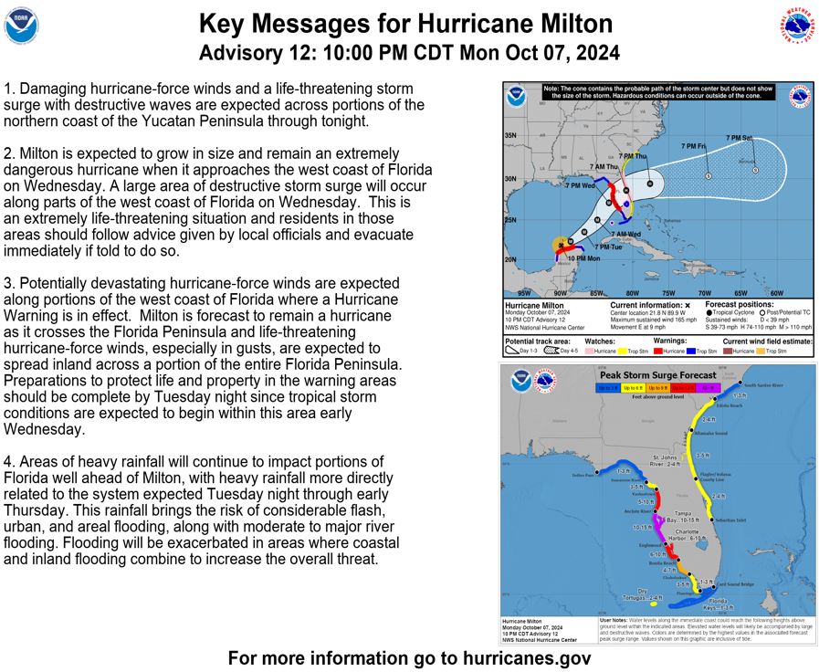
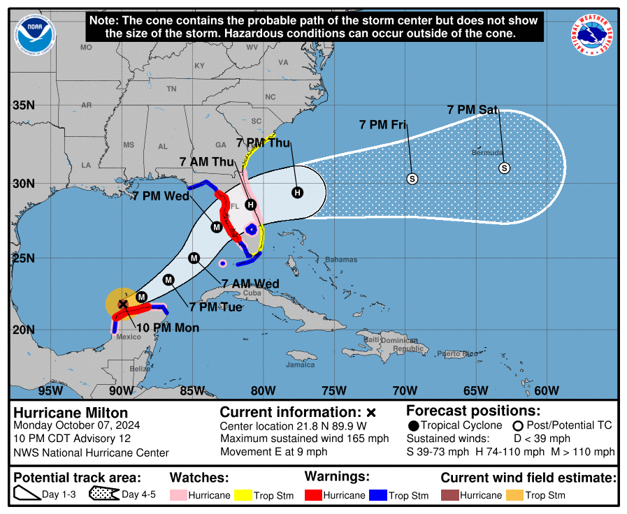
LOCATION…21.8N 89.9W
ABOUT 35 MI…60 KM NNW OF PROGRESO MEXICO
ABOUT 630 MI…1015 KM SW OF TAMPA FLORIDA
MAXIMUM SUSTAINED WINDS…165 MPH…270 KM/H
PRESENT MOVEMENT…E OR 90 DEGREES AT 9 MPH…15 KM/H
MINIMUM CENTRAL PRESSURE…914 MB…26.99 INCHES
A Storm Surge Warning is in effect for…
* West coast of Florida from Flamingo northward to the Suwannee
River, including Charlotte Harbor and Tampa Bay
A Hurricane Warning is in effect for…
* Celestun to Rio Lagartos
* Florida west coast from Bonita Beach northward to the mouth of the
Suwannee River, including Tampa Bay
A Storm Surge Watch is in effect for…
* Sebastian Inlet to Edisto Beach, including St. Johns River
A Hurricane Watch is in effect for…
* Rio Lagartos to Cabo Catoche
* Campeche to south of Celestun
* Dry Tortugas
* Lake Okeechobee
* Florida west coast from Chokoloskee to south of Bonita Beach
* Florida east coast from the St. Lucie/Indian River County Line
northward to the mouth of the St. Marys River
A Tropical Storm Warning is in effect for…
* Rio Lagartos to Cancun
* Campeche to south of Celestun
* All of the Florida Keys, including Dry Tortugas
* Lake Okeechobee
* Florida west coast from Flamingo to south of Bonita Beach
* Florida west coast from north of the mouth of the Suwanee River to
Indian Pass
A Tropical Storm Watch is in effect for…
* East coast of the Florida Peninsula south of the St. Lucie/Indian
River County Line southward to Flamingo
* Coast of Georgia and South Carolina from north of the mouth of the
St. Marys River to South Santee River, South Carolina
Right now, Milton has sustained winds of 165 mph, and a central pressure of 914 mb. The storm recently underwent an eyewall replacement cycle, which is likely the reason for the decreased wind speeds and increased pressure from the previous update. However, Milton should strengthen more in the overnight hours tonight. Then, sometime tomorrow, the storm will interact with areas of high wind shear, which could potentially reduce wind speeds by a small amount. Regardless, Milton will still be an extremely dangerous storm at landfall, and Floridians should treat the storm as such.
From the NHC: “Residents in Florida should closely follow the orders from their local emergency management officials, as Milton has the potential to be one of the most destructive hurricanes on record for west-central Florida.”
ADVICE: Do not treat this hurricane lightly. Do whatever you must do to protect yourself and others from being a victim to this storm. There is still time, although it is limited, to prepare and/or evacuate.
Tropical storm force winds are expected to be present along the Florida Coast sometime Wednesday morning, so all preparations must be complete by tomorrow night.
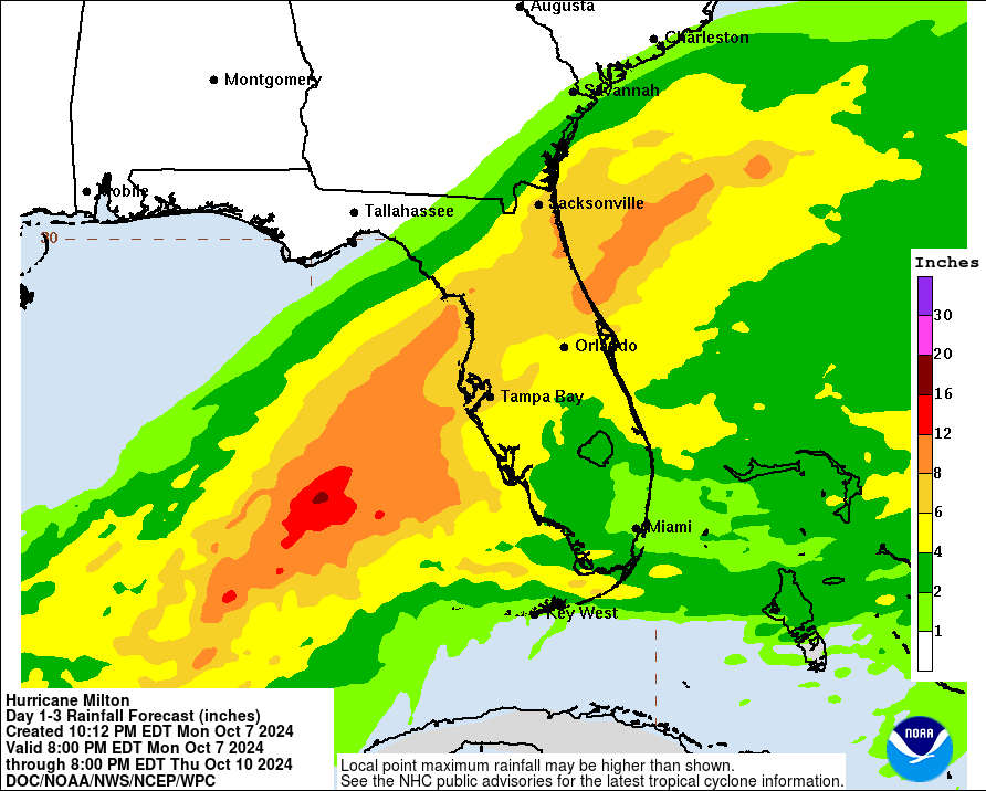
Rainfall has already begun in parts of Florida unrelated to Milton, and much more rainfall will occur once Milton reaches Florida. This, combined with storm surge, will lead to life-threatening flood conditions.
Rainfall amounts between 2 and 10 inches are expected in various parts of Florida, with the most rain occurring in North/Central Florida. Here is a graphic outlining expected rainfall amounts:
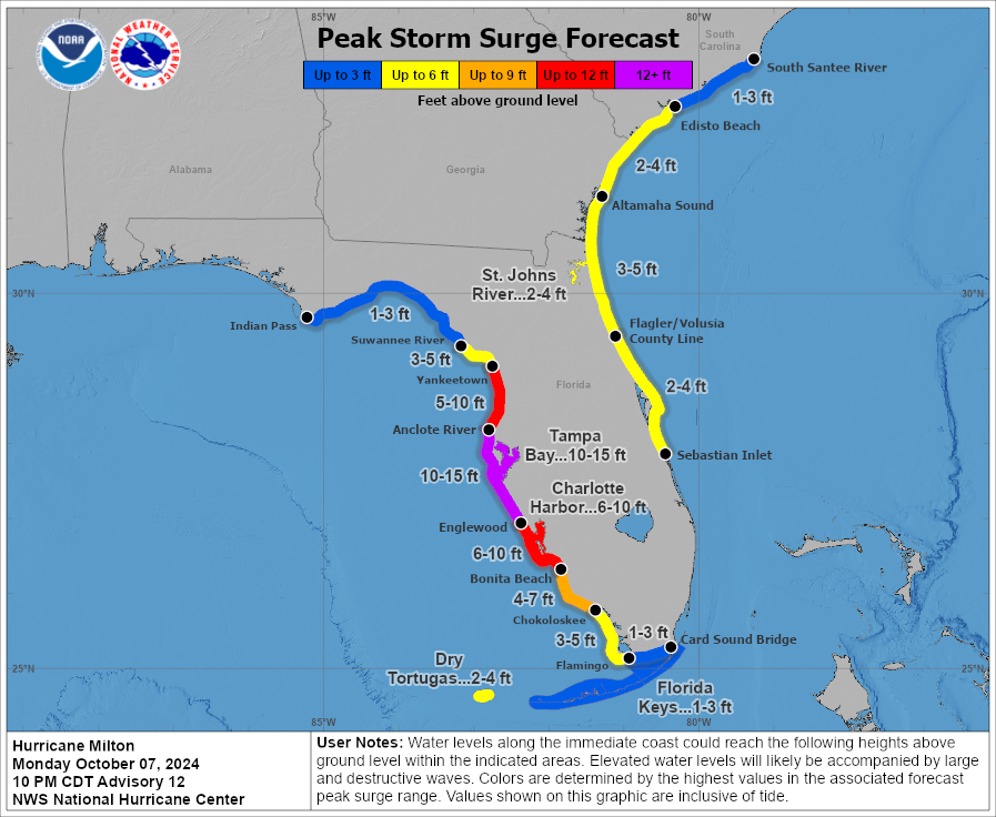
Storm surge amounts of 1 to 15 ft are expected along many parts of both Floridian Coasts. The highest surge, between 10 to 15 ft or more, is expected in and around Tampa Bay. Here are all the forecasted storm surge amounts:
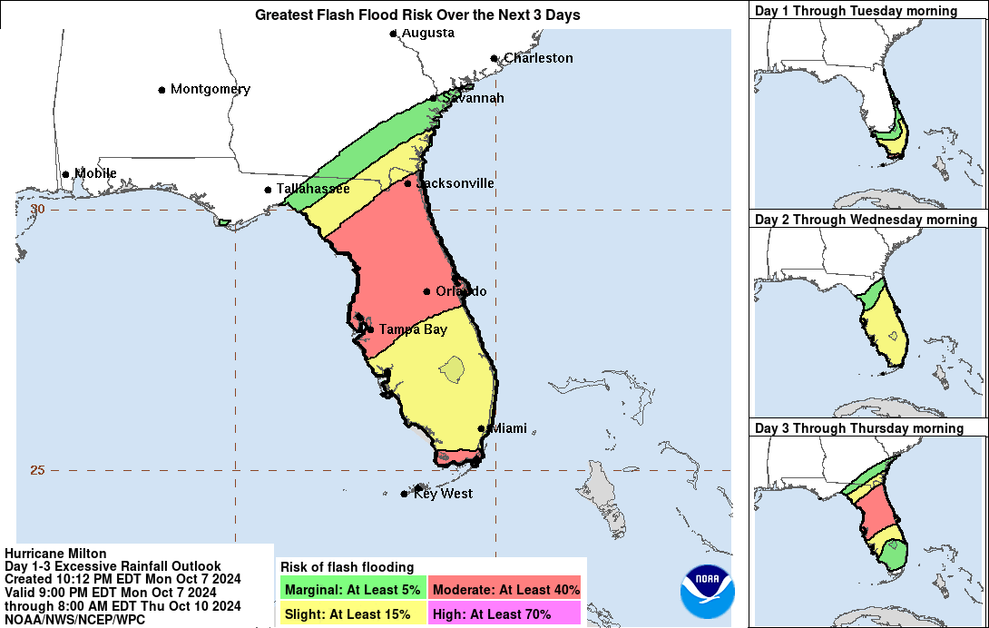
As a result of rainfall and surge, flash flooding is very likely to occur. Central Florida (including Tampa Bay to Orlando, and north all the way up to Jacksonville) will see the highest risk of flash flooding. Here is a graphic outlining the areas of concern:
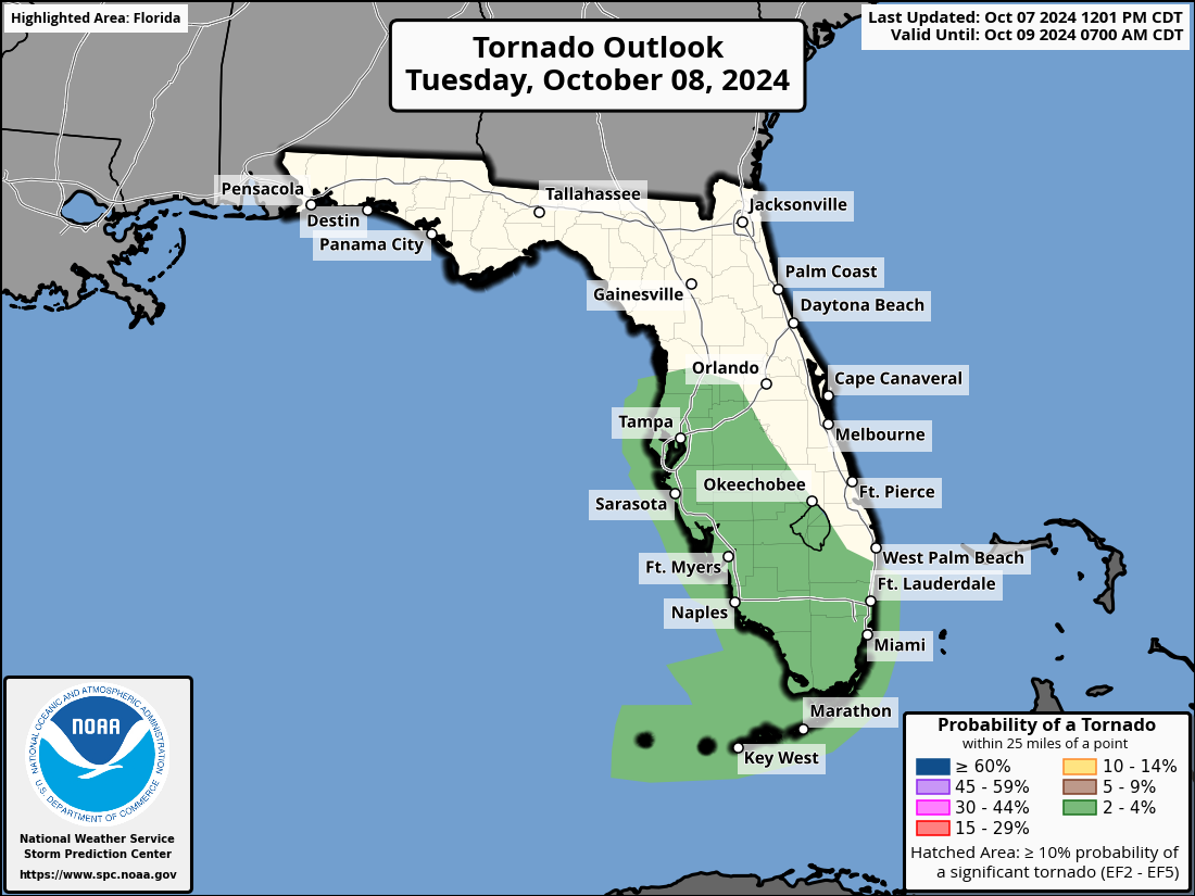
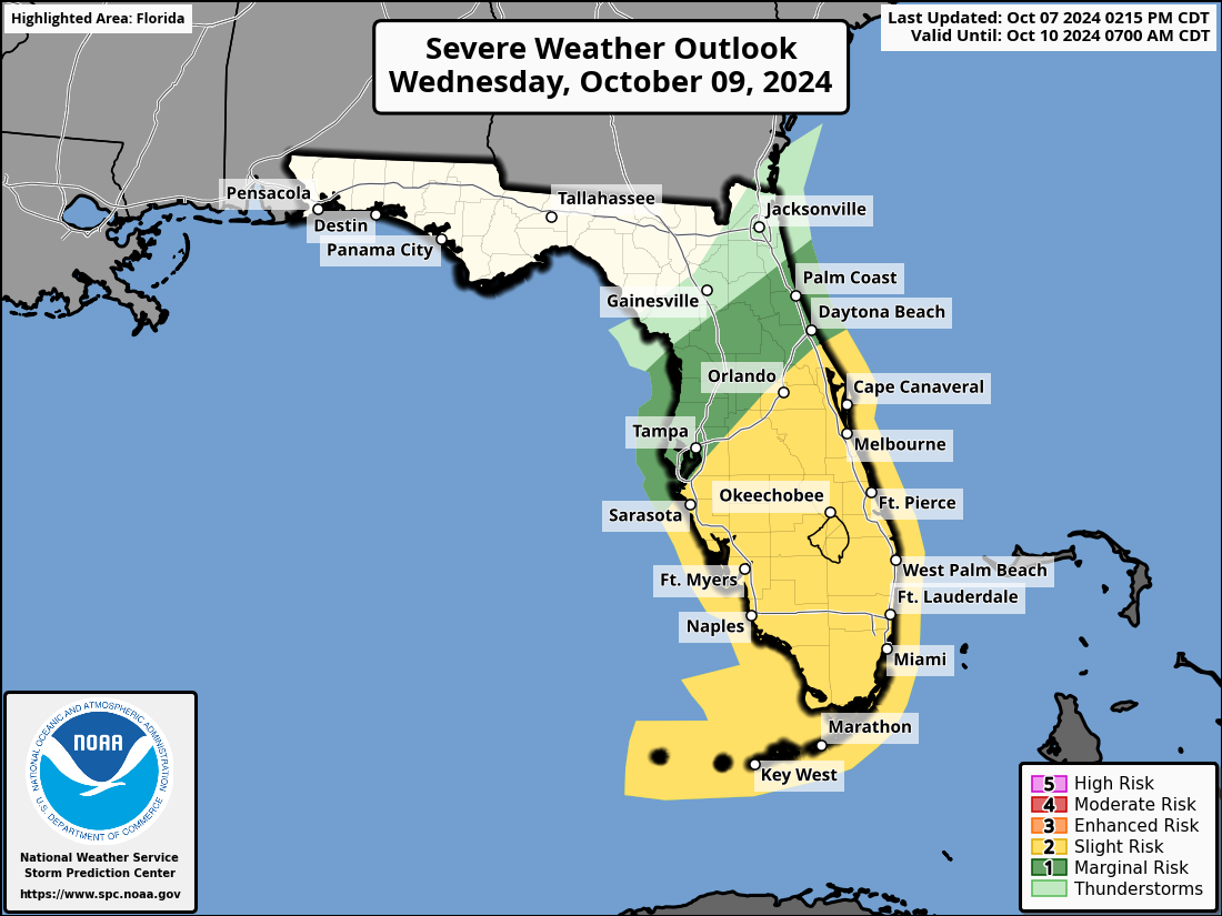
As is the case with most landfalling hurricanes, there is a strong possibility of embedded tornadoes within the outer bands of Milton once they are over land. For tomorrow, the SPC has outlined areas in Central and Southern Florida with a marginal risk of tornado occurrence. For Wednesday, much of Florida is highlighted as having a severe weather threat.
Many counties in Florida have issued mandatory evacuation orders. Please visit https://www.floridadisaster.org/evacuation-orders/ for more information and a complete map of current orders.
We will continue to update as we get new information. Please share this information with anyone you may know in the impact zones.
Category: ALL POSTS, Social Media, Tropical
About the Author (Author Profile)
Scott is a senior at Mississippi State University studying professional and broadcast meteorology.Subscribe
If you enjoyed this article, subscribe to receive more just like it.


