
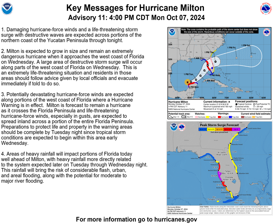
4PM CDT Hurricane Milton Update: Winds Continue to Pick Up While Pressure Rapidly Drops
The NHC has released their 4pm CDT advisory, and things are not looking any better down in the Gulf. Winds are now at 180 mph, and the pressure is 905 mb. This is a drastic change from this time yesterday (pressure is down 93 mb in just 24 hours). Another Hurricane Hunters aircraft will investigate Milton later this evening.

Here is the latest from the NHC:
SUMMARY OF 400 PM CDT…2100 UTC…INFORMATION
———————————————-
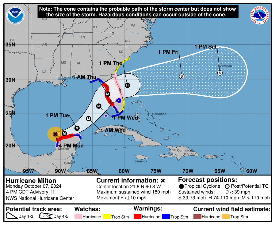
LOCATION…21.8N 90.8W
ABOUT 80 MI…125 KM WNW OF PROGRESO MEXICO
ABOUT 675 MI…1085 KM SW OF TAMPA FLORIDA
MAXIMUM SUSTAINED WINDS…180 MPH…285 KM/H
PRESENT MOVEMENT…E OR 90 DEGREES AT 10 MPH…17 KM/H
MINIMUM CENTRAL PRESSURE…905 MB…26.73 INCHES
A Storm Surge Warning is in effect for…
* West coast of Florida from Flamingo northward to the Suwannee
River, including Charlotte Harbor and Tampa Bay
A Hurricane Warning is in effect for…
* Celestun to Rio Lagartos
* Florida west coast from Bonita Beach northward to the mouth of the
Suwannee River, including Tampa Bay
A Storm Surge Watch is in effect for…
* Sebastian Inlet to Edisto Beach, including St. Johns River
A Hurricane Watch is in effect for…
* Rio Lagartos to Cabo Catoche
* Campeche to south of Celestun
* Dry Tortugas
* Lake Okeechobee
* Florida west coast from Chokoloskee to south of Bonita Beach
* Florida east coast from the St. Lucie/Indian River County Line
northward to the mouth of the St. Marys River
A Tropical Storm Warning is in effect for…
* Rio Lagartos to Cancun
* Campeche to south of Celestun
* All of the Florida Keys, including Dry Tortugas
* Lake Okeechobee
* Florida west coast from Flamingo to south of Bonita Beach
* Florida west coast from north of the mouth of the Suwanee River to
Indian Pass
A Tropical Storm Watch is in effect for…
* East coast of the Florida Peninsula south of the St. Lucie/Indian
River County Line southward to Flamingo
* Coast of Georgia and South Carolina from north of the mouth of the
St. Marys River to South Santee River, South Carolina
CHILLING MESSAGE FROM THE NHC: “Residents in Florida should closely follow the orders from their local emergency management officials, as Milton has the potential to be one of the most destructive hurricanes on record for west-central Florida.“
KEY POINTS:
1. Milton will be an extremely dangerous hurricane at landfall. The storm will continue to strengthen overnight tonight as it continues to pass through virtually no wind shear and very warm waters. The NHC is also saying that the storm is likely beginning to undergo an eyewall replacement cycle, meaning that the storm will temporarily weaken, but grow much larger. This should occur tonight and be completed by tomorrow. After that, the storm should weaken weaken some on Tuesday as it passes through much less favorable conditions.
2. There will be a large area of storm surge along parts of the Florida Coast on Wednesday. Flooding is a huge concern with this system. Additionally, hurricane force winds will extend well away from the center of the storm, and wind gusts will be extremely high. The NHC notes that preparations to preserve life and property must be complete by tomorrow night.
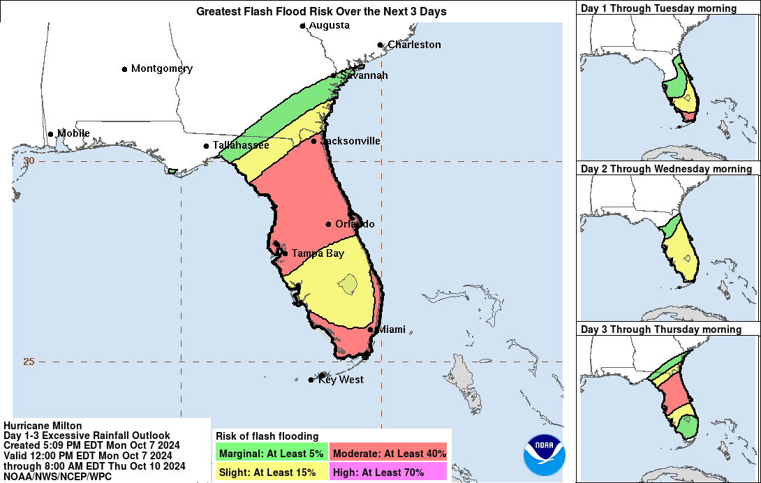
3. Along with storm surge, large amounts of rainfall will occur. This will add to the flooding threat in central and southern Florida.
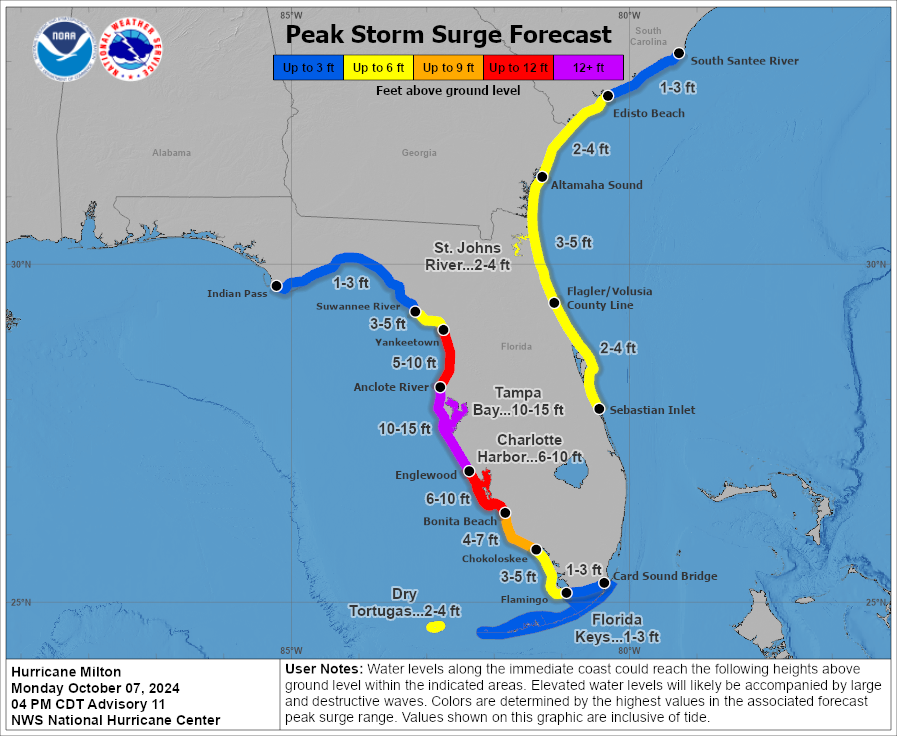
STORM SURGE:
The largest area of storm surge will include Tampa Bay and surrounding areas… surge levels of 10 to 15 feet are possible.
Much of the rest of the Florida Coast will have a risk for storm surge as well. Here are all the areas of concern:
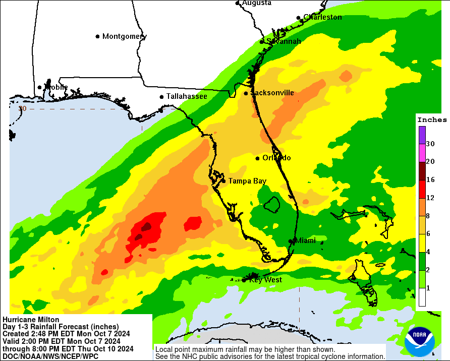
RAINFALL AND FLASH FLOODING:
These graphics outline potential rainfall amounts, as well as areas of flash flood risk:
MODEL GUIDANCE:
There is increasing confidence that the hurricane will make landfall near Tampa Bay. The GFS is showing a Wednesday evening landfall, while the EURO is showing landfall occurring slightly later Wednesday night:
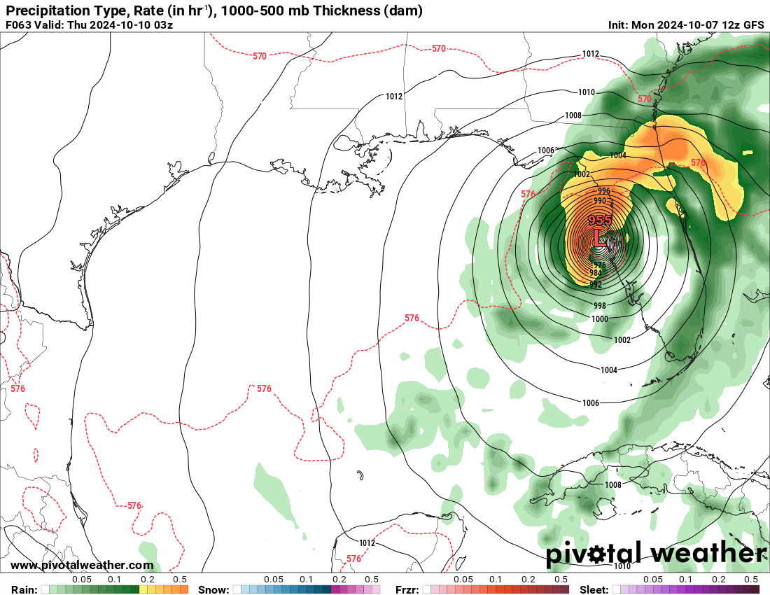
GFS Model
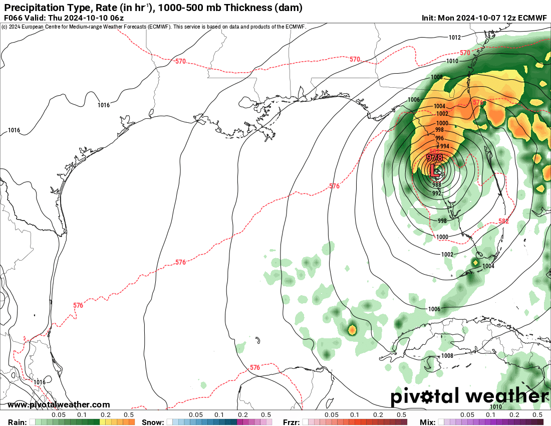
EURO Model
EVACUATIONS:
A few areas in Central Florida have already began mandatory evacuations. Please refer to local officials regarding planning/evacuations if you are located in an impact area. For more information, please visit: www.floridadisaster.org/evacuation-orders/
This storm will be extremely dangerous, and will pose life-threatening risks to those in the impact areas. Please take this storm very seriously, and listen to local officials. We will continue to update as new information comes in.
Category: ALL POSTS, Social Media, Tropical
About the Author (Author Profile)
Scott is a senior at Mississippi State University studying professional and broadcast meteorology.Subscribe
If you enjoyed this article, subscribe to receive more just like it.


