Midday Nowcast: Here Comes Fall, while Milton expected to be Category 5 very soon
FRONT ON THE WAY: Temperatures today reach the mid 80s under a sky full of sunshine. Overnight, a dry cold front will bring cooler air down into the state, giving many of us the first true taste of fall weather. We expect lows down in the 50s early tomorrow.
BIRMINGHAM ALMANAC: For October 7th, the average high for Birmingham is 79° and the average low is 58°. The record high is 93° set in 1925, while the record low is 34° set in 1991. We average 0.09” of precipitation on this date, and the record value is 1.97” set in 1955.
REST OF WEEK: We expect sunny days and fair cool nights the rest of this week and through the weekend. Highs will be in the upper 70s and low 80s, with lows in the 50s. Some of the colder pockets across North Alabama could reach the 40s early Friday morning. It will be a very dry air mass, meaning no humidity, and no rain as a long dry spell settles into Alabama. The pattern doesn’t change as we roll into next week.
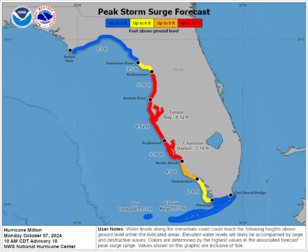
HURRICANE MILTON: Milton is rapidly intensifying as the pressure continues to fall like a rock. This will be a life-threatening and devastating storm for the state of Florida this week, with record storm surges along the west coast of Florida.
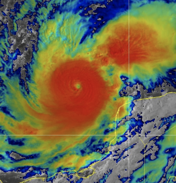
Latest update from the National Hurricane Center has the pressure down to 933 mb. The pressure continues to fall, and before the next update, I expect Milton to be a category 5 hurricane.
At 1000 AM CDT, the eye of Hurricane Milton was located near latitude 21.7 North, longitude 91.7 West. Milton is moving toward the east-southeast near 9 mph. An eastward to east-southeastward motion is forecast through tonight, followed by a turn toward the east and northeast on Tuesday and Wednesday. On the forecast track, Milton is forecast to move near or just north of the Yucatan Peninsula today and Tuesday, then cross the eastern Gulf of Mexico and approach the west coast of the Florida Peninsula by Wednesday.
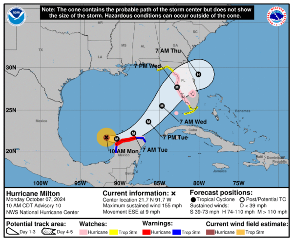
Data from NOAA and Air Force Reserve Hurricane Hunter aircraft indicate that the maximum sustained winds have increased to near 155 mph with higher gusts. Milton is a category 4 hurricane on the Saffir-Simpson Hurricane Wind Scale. Milton is forecast to become a category 5 hurricane later today and become a large hurricane over the eastern Gulf of Mexico. The estimated minimum central pressure is 933 mb (27.55 inches) based on Air Force Reserve dropsonde data.
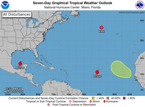
REST OF THE TROPICS: Hurricane Kirk has become post-tropical, Hurricane Leslie will remain a fish storm, and also along with another area of potential development off the African coast.
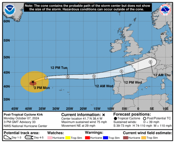
KIRK: The center of Post-Tropical Cyclone Kirk was located near latitude 41.7 North, longitude 38.4 West. The post-tropical cyclone is moving toward the northeast near 29 mph. An even faster east-northeastward motion is expected during the next couple of days. Maximum sustained winds are near 75 mph with higher gusts. Although gradual weakening is expected, Kirk is forecast to remain a large and strong extratropical low during the next couple of days. The estimated minimum central pressure is 963 mb (28.44 inches).
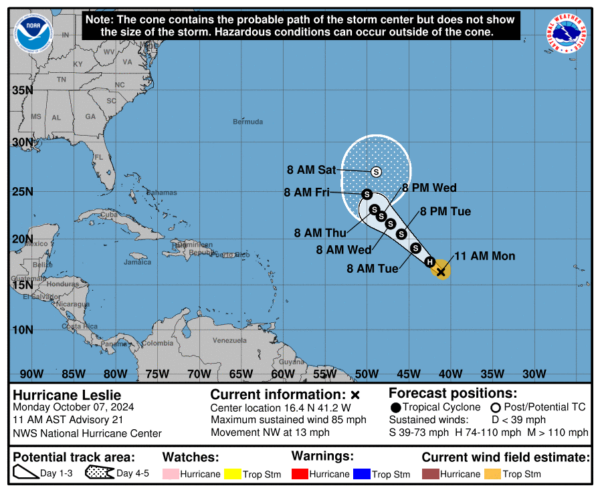
HURRICANE LESLIE: The center of Hurricane Leslie was located near latitude 16.4 North, longitude 41.2 West. Leslie is moving toward the northwest near 13 mph and this general motion is expected to continue over the next few days followed by a turn toward the north-northwest on Friday. Maximum sustained winds are near 85 mph with higher gusts. Gradual weakening is forecast through the week, and Leslie is expected to weaken to a tropical storm in a day or so. The estimated minimum central pressure is 985 mb (29.09 inches).
Finally, a tropical wave is expected to move off the west coast of Africa in a few days. Afterward, environmental conditions appear marginally favorable for some slow development of this system while it moves westward or west-northwestward across the eastern tropical Atlantic. The system is expected to move near or over the Cabo Verde Islands on Thursday or early Friday, and interests there should monitor its progress. Formation chance through 7 days…low…30 percent.
Next name up is Nadine.
WORLD TEMPERATURE EXTREMES: Over the last 24 hours, the highest observation outside the U.S. was 113.9F at Ejido Nuevo León, Mexico. The lowest observation was -91.7F at Vostok, Antarctica.
CONTIGUOUS TEMPERATURE EXTREMES: Over the last 24 hours, the highest observation was 116F at Indio and Ocotillo Wells, CA. The lowest observation was 21F at Peter Sinks, UT.
Category: Alabama's Weather, ALL POSTS, Social Media
About the Author (Author Profile)
Macon, Georgia Television Chief Meteorologist, Birmingham native, and long time Contributor on AlabamaWX. Stormchaser. I did not choose Weather, it chose Me. College Football Fanatic. @Ryan_StinnetSubscribe
If you enjoyed this article, subscribe to receive more just like it.


