Milton Now Near Cat 5 Strength. Max Winds 155 mph. Pressure Down to 933 MB.
There has been an 80 knot increase in the max winds in 24 hours. This makes Milton the third most extreme rapid intensification event only surpassed by Felix in 2007 and Wilma in 2005!
It is time to break down this very important update from the NHC.
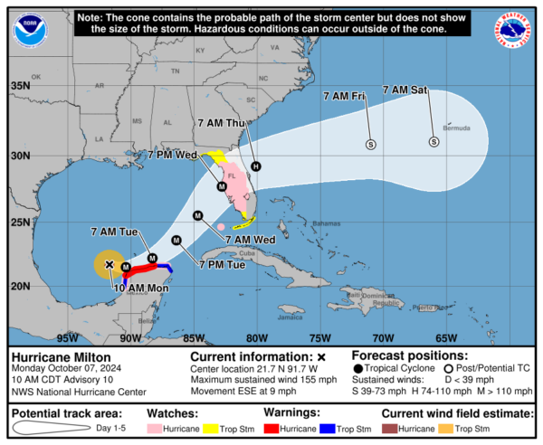
SUMMARY OF 1000 AM CDT…1500 UTC…INFORMATION
———————————————–
LOCATION…21.7N 91.7W
ABOUT 130 MI…210 KM WNW OF PROGRESO MEXICO
ABOUT 720 MI…1160 KM SW OF TAMPA FLORIDA
MAXIMUM SUSTAINED WINDS…155 MPH…250 KM/H
PRESENT MOVEMENT…ESE OR 110 DEGREES AT 9 MPH…15 KM/H
MINIMUM CENTRAL PRESSURE…933 MB…27.55 INCHES
The only advisory change is to add a hurricane watch for Lake Okeechobee
We have been watching in real-time Milton rapidly intensify to almost a Cat 5. The NHC expects that to happen today and forecast peak winds to reach 165 mph over the next 12 hours. Hurricane-force winds extend outward up to 30 miles from the center and tropical-storm-force winds extend outward up to 80 miles. Dropsonde data shows the pressure drop down to 933 mb. Just saw this post from Philip Klotzbach showing the historic nature of Milton.
#Milton is now forecast to become a Category 5 #hurricane and reach a max intensity of 165 mph. If that forecast verifies, it would be the strongest Gulf of Mexico hurricane this late in the calendar year in the satellite era (1966-onwards). pic.twitter.com/WvJFsZzMBD
— Philip Klotzbach (@philklotzbach) October 7, 2024
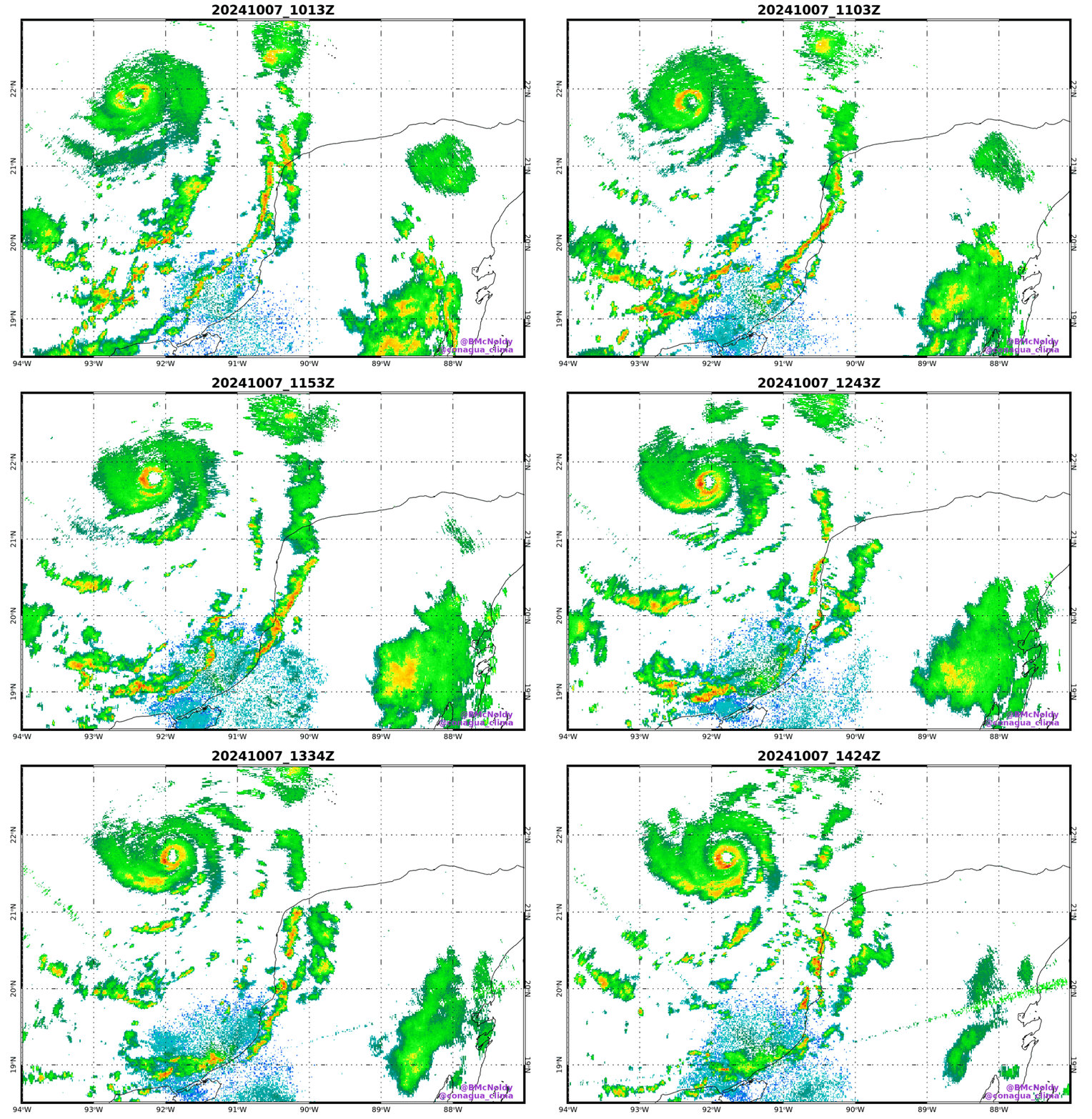
Here is a radar look at Milton from Brian McNoldy, Univ. of Miami, Rosenstiel School.
Milton is moving ESE and this general movement will continue or even more of an easterly one possible in the near term. Hurricane force winds are still projected to swipe the Yucatan. A mid level trough is progged to sweep and in a help push Milton to the northeast and it should pick up pace as it is approaching the Florida West Coast. The latest models have moved the hurricane a bit more north and the NHC has pushed their projected path slightly north.
There is a lot of talk about weakening with Milton and that is still forecast. Weakening does NOT mean it won’t have major impacts! Hurricanes are not just one point on a map and yes we care about where it will come in for the peak impacts for surge and wind but there will be widespread problems for the state of Florida. Directly from the NHC:
Milton is likely to become a category 5 hurricane later today with light shear and very warm waters in its path. By tomorrow, its intensity should be dictated by any eyewall replacement cycles, which will likely cause the system to gradually weaken but grow larger. After 36 h, Milton is expected to encounter a much less favorable environment with strong shear and dry air entrainment. Therefore, some weakening is anticipated before the hurricane reaches the Florida Gulf coast. However, the system is still likely to be a large and powerful hurricane at landfall in Florida, with life-threatening hazards at the coastline and well inland.
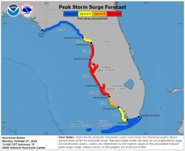
Hurricanes can only maintain such intensity for so long before they start going through eye replacement cycles and start being influence by factors like shear and dry air entrainment. When these things happen, more compact storms (like what Milton is now) will start to grow in size and have a larger wind field. Also, as I have said in other updates, the angle it is coming in will cause a HUGE push of water into the west coast of Florida. It has a couple of days to do so as landfall is not expected until maybe late Wed into Wed night. So all of that water will pile up and head toward the coast. Devastating storm surge threats are forecast.
Final thoughts:
Milton is forecast to strengthen to a Category 5 storm and eventually will start to encounter harsher conditions causing some weakening of the max winds but the overall windfield will get bigger. All tropical threats are in play for the Florida peninsula: surge, heavy rain and flooding, widespread damaging winds and tornadoes.
If you are in an evacuation zone and asked to leave, please do so. Folks really should be buttoning up their hurricane preparedness today. There will be time tomorrow but better to get going now on what you need to do to protect life and property. Be prepared not scared.
Category: ALL POSTS, Social Media, Tropical


