
Special Intermediate Advisory from the NHC: New Advisories for Mexico, Milton is Increasing in Strength
Data from the NOAA and Air Force Hurricane Hunter Aircraft has led to the special advisory from the NHC about the track and intensity of Milton. The wind is up and the pressure is down.
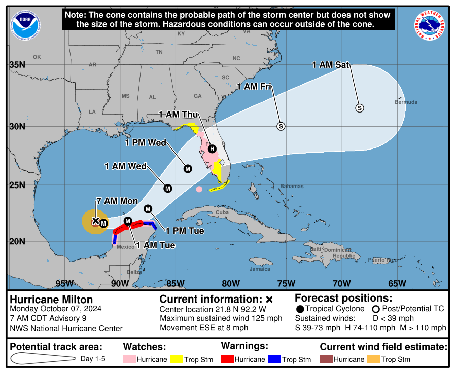
Stats:
LOCATION…21.8N 92.2W
ABOUT 165 MI…265 KM WNW OF PROGRESO MEXICO
ABOUT 745 MI…1195 KM WSW OF TAMPA FLORIDA
MAXIMUM SUSTAINED WINDS…125 MPH…205 KM/H
PRESENT MOVEMENT…ESE OR 115 DEGREES AT 8 MPH…13 KM/H
MINIMUM CENTRAL PRESSURE…945 MB…27.91 INCHES
A recent dropsonde found the pressure down to 945 mb, a 9 mb drop from the last dropsonde. Peak flight-level winds by the aircraft was estimated at 120 kts. With these readings, the NHC has upped the surface winds to 125mph. Rapid intensification is forecast over the next 24 hours and Milton could become a dangerous Category 4 within 24 hours. It would maintain that intensity until it encounters strong shear to help knock down the central winds. When that happens and how much is still in question and regardless a very dangerous hurricane will have huge impacts on Florida.
The NHC discussion denotes that no changes were made in the track beyond 36 hours. In the near term, there are increasing concerns for Mexico. The government of Mexico has issued a Hurricane Watch and a Tropical Storm Warning from south of Celestun to Campeche. The hurricane hunters found the storm moving slightly more to the south and the track was adjustment over the next 36 hours to show that. Hurricane-force winds are expected now for the northern coast of the Yucatan. 3-5 feet of surge expected now for the northern coast of the Yucatan Peninsula.
Category: ALL POSTS, Social Media, Tropical
About the Author (Author Profile)
Owner of Tornado Talk. Radio broadcast meteorologist with The Storm Report. WeatherBrains Panelist. B.S. Meteorology from Penn State University.Subscribe
If you enjoyed this article, subscribe to receive more just like it.


