10PM CDT Hurricane Milton Update: Wind Speeds up to 90mph; Pressure Now 977mb
Hurricane Milton is now a strong category 1 hurricane, and will likely reach category 2 status in the next few hours.
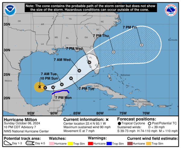
Here are the latest stats from the NHC 10PM CDT advisory:
SUMMARY OF 1000 PM CDT…0300 UTC…INFORMATION
———————————————–
LOCATION…22.4N 93.1W
ABOUT 230 MI…370 KM WNW OF PROGRESO MEXICO
ABOUT 765 MI…1235 KM WSW OF TAMPA FLORIDA
MAXIMUM SUSTAINED WINDS…90 MPH…150 KM/H
PRESENT MOVEMENT…E OR 100 DEGREES AT 7 MPH…11 KM/H
MINIMUM CENTRAL PRESSURE…977 MB…28.85 INCHES
SUMMARY OF WATCHES AND WARNINGS IN EFFECT:
A Hurricane Watch is in effect for…
* Celestun to Cabo Catoche
A Tropical Storm Warning is in effect for…
* Celestun to Cancun
KEY POINTS:
1. Milton is set to rapidly intensify overnight tonight, and will likely be a major hurricane by this time tomorrow. Robust convection is occurring in the storm, and the center is very healthy. The storm is showing no signs of being vertically titled and is fully symmetric, which is why it will continue to gain intensity over the next couple of days.
2. Milton will pass through very favorable conditions tomorrow and Tuesday, allowing it to potentially reach the category 4 threshold by Tuesday. Then, current model data shows the hurricane running into areas with higher wind shear, which may slightly weaken the storm before it makes landfall. Regardless, Milton will be an extremely large and dangerous storm at landfall on the Western Florida Peninsula.
3. Model guidance is still uncertain regarding the exact timing and track of Milton, but we should have a much better idea of the expected landfall area by this time tomorrow. Expected landfall is sometime Wednesday evening.
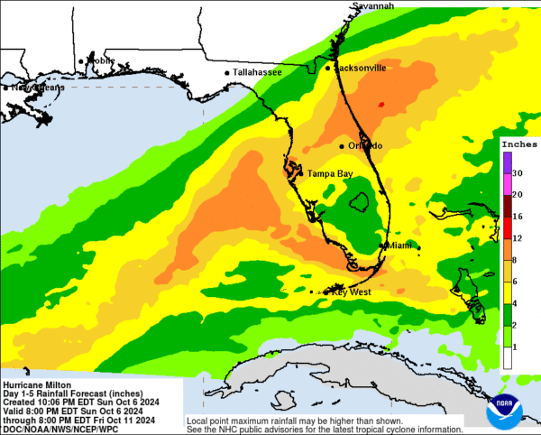
4. Many areas in Florida will start to see rainfall on Monday, with rain associated from Milton beginning on Tuesday. There is a large risk of flash flooding associated with this system.
MODEL DATA:
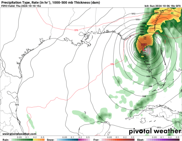
The latest run of the GFS has slowed the storm down significantly, placing landfall north of Tampa, FL on Thursday morning:
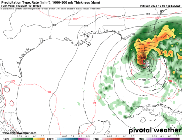
The EURO is still showing a landfall Wednesday evening with the center of the storm passing right over Tampa:
The ICON is different from both of these; it shows landfall occurring slightly south of Tampa in the afternoon hours of Wednesday:
As mentioned earlier, model data is still all over the place. This is mainly due to a complex atmospheric set up occurring right now. Because of this, the NHC is being very general in their messaging regarding the timing and location of this storm. The main takeaway should be that all areas of Central and Southern Florida should be prepared for this storm.
RAIN/FLASH FLOODING:
EVACUATIONS:
A few areas in Central Florida have already announced mandatory evacuations beginning tomorrow (Monday). Please listen to local officials regarding planning/evacuations if you are located in an impact area. For more information, please visit: www.floridadisaster.org/evacuation-orders/
Category: ALL POSTS, Social Media, Tropical


