4pm CDT Tropics Update: Milton Continues to Strengthen; Deep Convection in the Eyewall
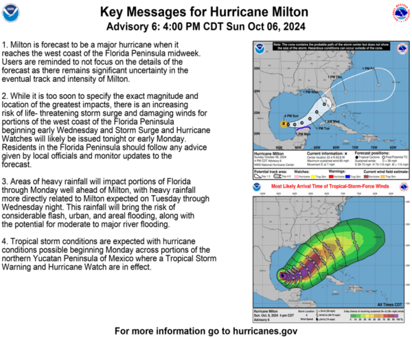
Time for a deep dive in the latest full update from the NHC. There is an increasing risk of life-threatening storm surge and damaging winds for portions of the west coast of the Florida Peninsula beginning early Wednesday, with impacts spreading further inland from there. Preparations need to be started now and folks need to heed the direction of their local officials…Now!
Stats:
LOCATION…22.4N 93.8W
ABOUT 275 MI…440 KM WNW OF PROGRESO MEXICO
ABOUT 805 MI…1295 KM WSW OF TAMPA FLORIDA
MAXIMUM SUSTAINED WINDS…85 MPH…140 KM/H
PRESENT MOVEMENT…E OR 100 DEGREES AT 7 MPH…11 KM/H
MINIMUM CENTRAL PRESSURE…983 MB…29.03 INCHES
Watches and Warnings:
New with this advisory: The government of Mexico has issued a Hurricane Watch for the north coast of the Yucatan Peninsula from Celestun to Cabo Catoche and a Tropical Storm Warning from east of Cabo Catoche to Cancun.
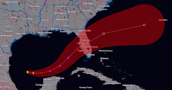
The NHC official forecast now calls for Milton to rapidly intensify to a Category 4 storm with max winds to 145 mph within 48 hours. From the discussion: Intensity guidance is about as bullish as I’ve seen in this part of the basin, with almost everything showing a peak intensity of category 4 or 5 in the southern Gulf of Mexico in a day or two. The NHC forecast is raised from the previous one and lies near the intensity consensus model and still could be too low.
Folks, there is a chance Milton could become a Cat 5. It is right now a smaller, more compact system with hurricane-force winds out 25 miles from the center. The tropical storm force winds are 80 miles from the center. Smaller storms can intensify very quickly.
By 60-72 hours out, Milton is forecast to move into a tremendously more sheared environment before landfall and max winds could be knocked down a bit into the category 3 range. The official forecast has a storm with max winds at 120 mph at 72 hours, before landfall would occur. Usually weakening is a good thing, but the models are showing that even if it weakens, the wind field could grow in size.
Regardless, a major hurricane will be approaching the west coast of Florida by Wednesday morning and moving at a pretty quick pace. It is just too difficult to say right now what the peak intensity will be and how much the shear could tear it apart before it makes landfall. Because of the way it is coming in, storm surge will be devastating for a large part of the coast and many areas will experience tropical storm and hurricane force winds. There is already heavy rain over the state and that will just be a predecessor to tropical rains that could enhance flooding.
Ending this update with the key messages from the NHC and words from my heart to please take this very seriously. If you are in an evacuation zone and asked to leave….please do so. Put your hurricane plans in place if you are far enough inland and can stay. Be prepared to have no power and/or cell phone service for many days. Make sure to get your items for your emergency kit and grab non-perishable foods.
Category: ALL POSTS, Social Media, Tropical


