A Long Stretch of Dry Weather Ahead; All Eyes on a Strengthening Milton
Some showers and storms will be possible today over the southeastern corner of Central Alabama from a stalled out boundary to our south, while the rest of the area will be dry with partly cloudy skies. Highs will top out in the upper 70s to the upper 80s. Another frontal boundary will push through the area on Monday, which will push out any shower activity and reinforce the dry air across Central Alabama. Skies will be mostly sunny with highs in the upper 70s to the upper 80s. On Tuesday, a surface high will set up north of us over the Ohio Valley, which will continue to send dry air in our direction. It will be quite breezy at times as we will be in a tight pressure gradient between the high and Milton. Highs will be cooler, topping out in the mid 70s to the mid 80s.
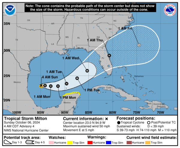
Wednesday will be nearly an exact copy of Tuesday’s weather. Sunny skies with highs in the mid 70s to the lower 80s. It also looks like we’ll have a potential landfall of Milton on the west coast of the Florida Peninsula. More dry weather with sunny skies can be expected on Thursday as Milton’s influence will keep pulling dry continental air into the state. Highs in the mid 70s to the lower 80s. On Friday, we’ll continue to be sunny and dry with highs in the mid 70s to the lower 80s. And at the end of the forecast period on Saturday, skies will continue to be sunny and highs will be in the mid to upper 70s.
—
Tropical Update as of 6 AM CDT this morning:
Tropical Storm Milton continues to strengthen in the Gulf of Mexico, now with sustained winds of 50 mph and higher gusts. Currently located at 23.0N 94.9W, Milton is moving east at 5 mph. It is expected to approach the west coast of Florida by midweek. Hurricane Hunter aircraft is on the way to investigate the storm. Hurricane and storm surge watches for portions of Florida are likely later today. Milton could become a hurricane by tonight and may reach major hurricane strength as it moves across the Gulf of Mexico. Heavy rainfall is expected across Florida, with totals of 5 to 8 inches and isolated amounts up to 12 inches. This could lead to flash flooding, urban flooding, and river flooding. Dangerous surf and rip currents will develop along the Gulf Coast early next week.
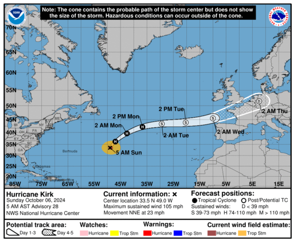
Hurricane Kirk is accelerating north-northeastward over the open Atlantic, with maximum sustained winds of 105 mph. Although weakening is expected, Kirk will remain a large hurricane for the next day before transitioning to an extratropical cyclone by early Tuesday. Swells generated by Kirk are affecting the U.S. East Coast, posing a risk of life-threatening rip currents.
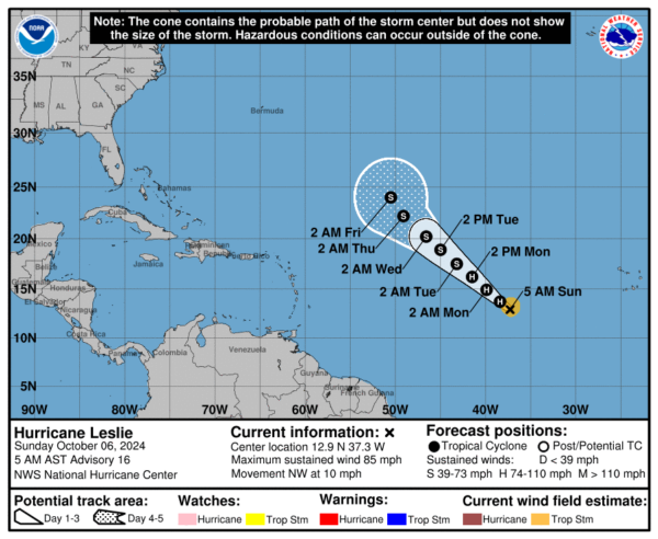
Hurricane Leslie has strengthened slightly, with maximum sustained winds of 85 mph. It’s currently located about 875 miles west of the southernmost Cabo Verde Islands, moving northwest at 10 mph. While small intensity fluctuations may occur today, Leslie is expected to begin weakening on Monday, continuing through midweek.
A tropical wave is expected to emerge from the west coast of Africa in the coming days, with some potential for development as it moves westward or west-northwestward across the eastern tropical Atlantic. Currently, the formation chance over the next 48 hours is low at near 0 percent, but the chance of development increases slightly to 30 percent over the next 7 days.
Category: Alabama's Weather, ALL POSTS, Severe Weather, Social Media, Tropical, Weather Xtreme Videos


