
TD-14 Forms in the Southwestern Gulf of Mexico; Forecast to Strengthen and Bring Life-Threatening Impacts to Florida’s West Coast Next Week
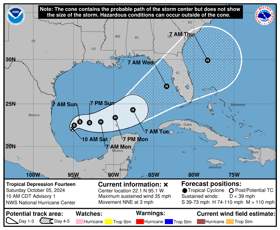
Satellite imagery shows that the low pressure area over the southwestern Gulf of Mexico has become better organized, leading to the initiation of advisories for Tropical Depression Fourteen. The initial intensity is set at 30 knots, supported by overnight ASCAT data.
The depression is currently moving northeast at 3 knots and is expected to drift in that direction for the next day. A trough over the northwestern Gulf will cause it to turn east-northeastward at a faster speed by Tuesday, bringing it to the west coast of Florida by midweek. While track guidance is generally consistent, some differences exist in forward speed, with the NHC track slightly faster than consensus models.
The depression is in a favorable environment with low wind shear and warm sea surface temperatures, allowing for steady to rapid strengthening over the coming days. Initial intensification may be slow for the next 12 to 24 hours, but a faster rate is anticipated afterward. The NHC forecast calls for the system to approach major hurricane strength while moving across the central and eastern Gulf of Mexico, and life-threatening hazards are likely for the Florida Peninsula next week.
Key Messages:
– The depression is expected to quickly intensify and may reach major hurricane strength as it approaches the west coast of Florida by midweek.
– There is an increasing risk of life-threatening storm surge and wind impacts for portions of the Florida Peninsula starting late Tuesday or Wednesday. Residents should prepare their hurricane plans and stay informed.
– Heavy rainfall is anticipated across Florida on Sunday and Monday, with more intense rainfall expected from Tuesday to Wednesday, increasing the risk of flash flooding and river flooding.
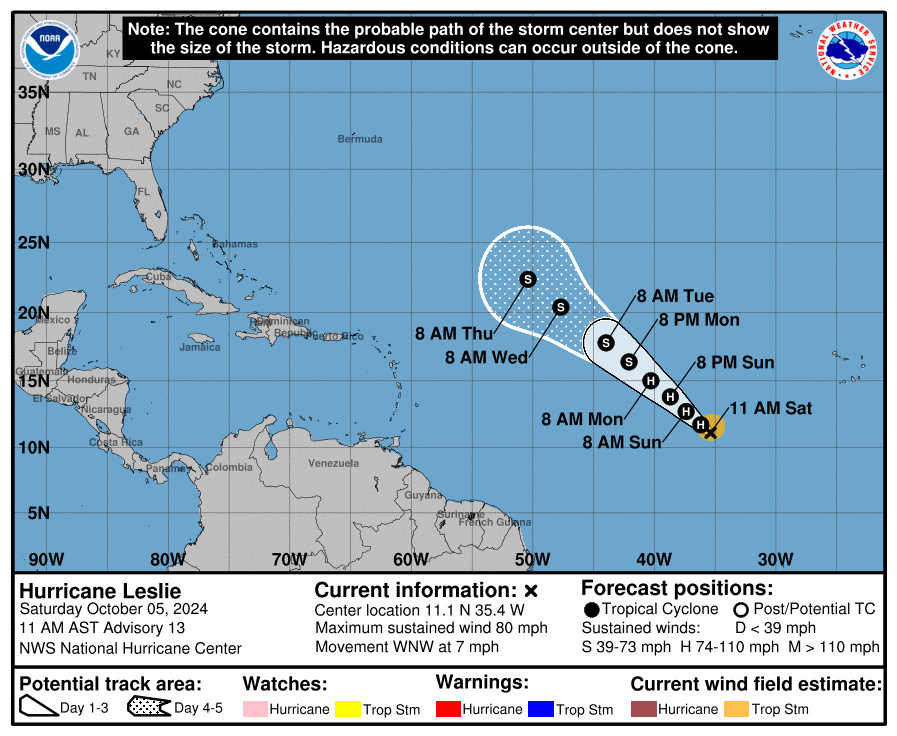
As of 11 AM AST, Hurricane Leslie is located about 785 miles west-southwest of the southern Cabo Verde Islands, with maximum sustained winds of 80 mph. It’s moving west-northwest at 7 mph and is expected to shift northwestward and speed up tonight through Tuesday. While some strengthening is possible today, a gradual weakening is forecast starting Sunday. Hurricane-force winds extend up to 15 miles from the center, and tropical-storm-force winds reach up to 105 miles. No coastal watches or warnings are currently in effect. The estimated minimum central pressure is 985 mb.
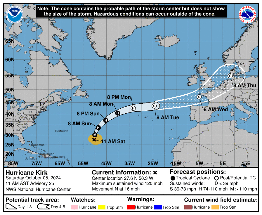
As of 11 AM AST, Hurricane Kirk is a major Category 3 storm located about 1,040 miles northeast of the northern Leeward Islands, with maximum sustained winds of 120 mph. It is moving north at 16 mph and is expected to turn northeastward by Sunday. While weakening is forecast early next week, Kirk will remain a large hurricane for the next few days. Hurricane-force winds extend up to 60 miles from the center, with tropical-storm-force winds reaching 230 miles. There are no coastal watches or warnings in effect, but swells from Kirk are impacting the Leeward Islands, Bermuda, and the Greater Antilles, and will reach the U.S. East Coast by Sunday, creating life-threatening surf and rip currents. The estimated minimum central pressure is 949 mb.
Category: ALL POSTS, Severe Weather, Social Media, Tropical
About the Author (Author Profile)
Scott Martin is an operational meteorologist, professional graphic artist, musician, husband, and father. Not only is Scott a member of the National Weather Association, but he is also the Central Alabama Chapter of the NWA president. Scott is also the co-founder of Racecast Weather, which provides forecasts for many racing series across the USA. He also supplies forecasts for the BassMaster Elite Series events including the BassMaster Classic.Subscribe
If you enjoyed this article, subscribe to receive more just like it.


