Midday Nowcast: Some Showers Today; Tropical Atlantic Remains Active
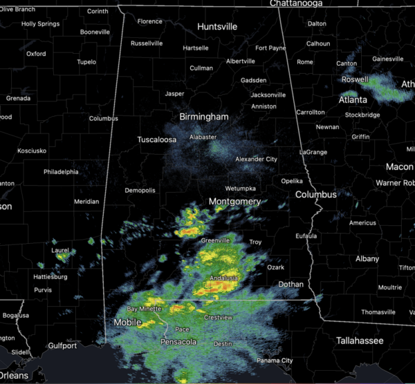
A few scattered showers are possible statewide today, but most of them will be across the southern half of the state. Rain is possible, but these showers should remain few and far between across the northern half of the state. Highs will be mostly in the low 80s this afternoon.
FRIDAY NIGHT LIGHTS: Just a small risk of a shower during the first quarter, but most stadiums will be dry and pleasant for the high school games tonight; temperatures will fall through the 70s.
BIRMINGHAM ALMANAC: For October 3rd, the average high for Birmingham is 81° and the average low is 59°. The record high is 98° set in 2019, while the record low is 35° set in 1987. We average 0.12” of precipitation on this date, and the record value is 3.02” set in 1995 (Hurricane Opal related).
ACROSS THE USA: A strong Bering Sea storm will continue to impact the Aleutian Islands and parts of southwestern Alaska today. High Wind Warnings have been issued for the entire Aleutian Island chain. Across the Great Basin and northern Rockies, strong winds and dry conditions will lead to critical fire weather conditions today as a strong Pacific system moves inland.
WEEKEND AND BEYOND: Expect a partly to mostly sunny sky tomorrow and Sunday with highs in the low 80s. A front will move through the state early next week, likely in dry fashion, but will bring that first true taste of fall next week. The weather will be dry and cooler with highs dropping into the upper 70s along with lows in the 50s with some upper 40s expected, especially in those colder spots.
FOOTBALL WEATHER: Tomorrow UAB will host Tulane at Protective Stadium in downtown Birmingham (12:00p CT kickoff)… the sky will be mostly sunny with temperatures in the low to mid 80s.
Auburn will be on the road at Georgia (2:30p CT kickoff)… the sky will be sunny with temperatures in the low 80s through most of the game.
Alabama travels to Nashville to take on Vanderbilt (3:15p CT kickoff)… expect a sunny sky with temperatures falling from near 85 degrees at kickoff, to near 80 by the final whistle.
LEFT TURNS ONLY: Just an outside risk of a shower tomorrow at Talladega, otherwise warm and dry through the weekend with highs in the mid 80s. Lows will be in the 60s.
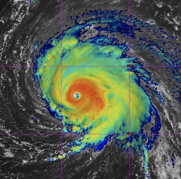
IN THE TROPICS: Kirk remains a major hurricane. the center of Hurricane Kirk was located near latitude 23.0 North, longitude 48.9 West. Kirk is moving toward the northwest near 12 mph, and this general motion is expected to continue today. A turn toward the north and north-northeast at a faster forward speed is anticipated over the weekend.
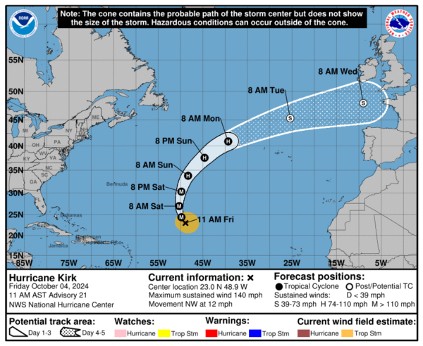
Maximum sustained winds are near 140 mph with higher gusts. Kirk is a category 4 hurricane on the Saffir-Simpson Hurricane Wind Scale. Small intensity fluctuations are possible today and tonight. Weakening is forecast to begin on Saturday and continue through early next week. The estimated minimum central pressure is 939 mb (27.73 inches).
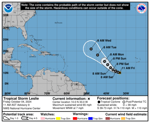
Leslie: The center of Tropical Storm Leslie was located near latitude 10.0 North, longitude 33.0 West. Leslie is moving toward the west-northwest near 7 mph. A turn toward the west-northwest is expected later today, followed by a turn toward the northwest and an increase in forward speed early Sunday into Monday. Maximum sustained winds have increased to near 65 mph with higher gusts. Additional strengthening is forecast, and Leslie is expected to become a hurricane tonight or Saturday. The estimated minimum central pressure is 996 mb (29.42 inches).
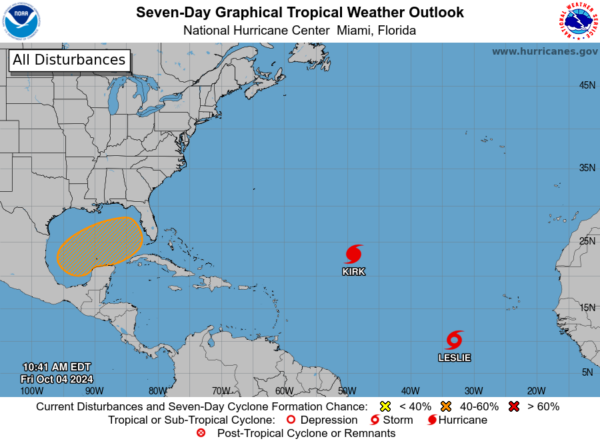
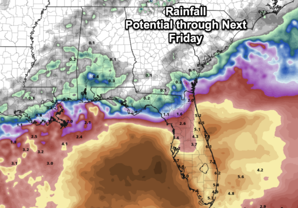
In the Gulf, disorganized showers and thunderstorms located over the western Gulf of Mexico are associated with a trough of low pressure. A broad area of low pressure is expected to form over the southwestern or south-central Gulf of Mexico this weekend, and thereafter some gradual development is possible while the low moves slowly eastward or northeastward. A tropical or subtropical depression or storm could form during the early to middle part of next week if the low remains separate from a frontal boundary that is forecast to extend across the Gulf of Mexico next week. Regardless of tropical or subtropical development, locally heavy rains could occur over portions of Mexico during the next few days and over portions of the Florida Peninsula late this weekend into next week. Formation chance through 7 days…medium…40 percent.
Next name up is Milton.
WORLD TEMPERATURE EXTREMES: Over the last 24 hours, the highest observation outside the U.S. was 110.7F at Ejido Nuevo León, Mexico. The lowest observation was -89.7F at Vostok, Antarctica.
CONTIGUOUS TEMPERATURE EXTREMES: Over the last 24 hours, the highest observation was 112F at Death Valley and Ocotillo Wells, CA. The lowest observation was 12F at Bynum, MT.
Category: Alabama's Weather, ALL POSTS, Social Media
About the Author (Author Profile)
Macon, Georgia Television Chief Meteorologist, Birmingham native, and long time Contributor on AlabamaWX. Stormchaser. I did not choose Weather, it chose Me. College Football Fanatic. @Ryan_StinnetSubscribe
If you enjoyed this article, subscribe to receive more just like it.


