
A Few Showers Today; Warm Afternoons Continue
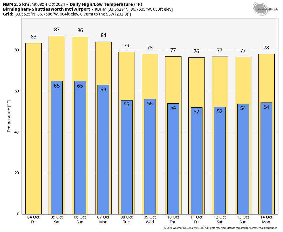
RADAR CHECK: We have a few areas of mostly light rain over the southern half of Alabama early this morning, otherwise the sky is mostly cloudy with temperatures in the upper 60s and low 70s. We are forecasting a mix of sun and clouds today with scattered showers possible, with the highest coverage over the southern counties. The weather stay warm with a high in the 80-85 degree range this afternoon.
THE ALABAMA WEEKEND: Highs remain in the 80s tomorrow and Sunday with a partly to mostly sunny sky both days. We will keep some risk of isolated showers in the forecast for the far southern part of Alabama, but nothing widespread or heavy.
COOL CHANGE: While Monday will be another warm day, a dry cold front will bring a cool change to the Deep South beginning Tuesday. Highs drop into the 70s over North/Central Alabama, with lows in the 50s. The high will be close to 80 over South Alabama, and the week will be dry with sunny days and fair nights. Quite frankly, we see no really significant rain event for Alabama for the next 10-15 days… this is common for October, which is the driest month of the year here based on climatology. See the video briefing for maps, graphics, and more details.
TROPICS: Hurricane Kirk remains is a powerful hurricane this morning with winds of 145 mph, but it is in the middle of the Atlantic far from land. It turns north, then northeast well east of the U.S. And, behind Kirk is Tropical Storm Leslie with winds of 60 mph. It should become a hurricane over the next 24 hours, but like Kirk it will remain far from land.
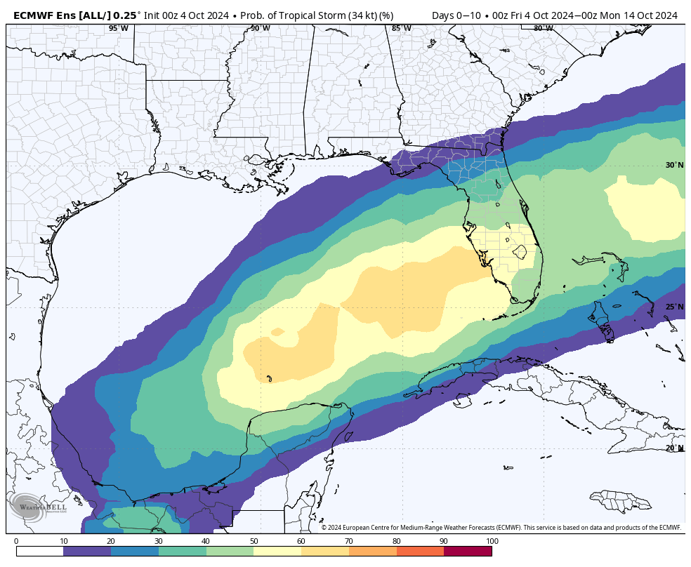
We continue to watch the southern Gulf of Mexico, where disorganized showers and thunderstorms are associated with a trough of low pressure. A broad area of low pressure is expected to form this weekend, and thereafter some gradual development is possible while the low moves slowly eastward or northeastward. A tropical or subtropical depression or storm could form during the early to middle part of next week if the low remains separate from a frontal boundary that is forecast to extend across the Gulf of Mexico next week. Regardless of tropical or subtropical development, locally heavy rains could occur over portions of Mexico during the next few days and over portions of the Florida Peninsula (not the panhandle) late this weekend into next week.
NHC gives the this feature a 40 percent chance of development. We see no risk of a tropical storm or hurricane for the Central Gulf Coast (Gulf Shores to Panama City Beach) for at least the next seven days.
FOOTBALL WEATHER: Just a small risk of a shower during the first quarter, otherwise mostly fair and pleasant for the high school games tonight; temperatures will fall through the 70s.
Tomorrow UAB will host Tulane at Protective Stadium in downtown Birmingham (12:00p CT kickoff)… the sky will be mostly sunny with temperatures in the low to mid 80s.
Auburn will be on the road at Georgia (2:30p CT kickoff)… the sky will be sunny with temperatures in the low 80s through most of the game.
Alabama travels to Nashville to take on Vanderbilt (3:15p CT kickoff)… expect a sunny sky with temperatures falling from near 85 degrees at kickoff, to near 80 by the final whistle.
RACE WEEKEND: Just an outside risk of a shower today at Talladega, otherwise warm and dry through the weekend with highs in the mid 80s. Lows will be in the 60s.
ON THIS DATE IN 1995: Opal made landfall at Pensacola Beach as a Category 3 hurricane with top sustained winds of 115 mph. Opal at that time was the first major hurricane to strike the Florida Panhandle since Eloise in 1975.
Opal’s legacy will always be the devastating storm surge that occurred across the coastal areas of the western Florida Panhandle. Storm surge of 10-15 feet was recorded from Navarre Beach east to Destin with 6-8 feet observed in the inland bays from Pensacola to Choctawhatchee Bay. Opal destroyed most of the homes that were facing the Gulf of Mexico from Navarre Beach to east of Destin.
Opal was a high impact event for most all of inland Alabama. Rainfall measured at the Birmingham Airport reached 6.94 Inches for the day, with major flooding in parts of the city. There were two storm related deaths in Gadsden, in Etowah County, when high wind toppled a massive oak tree onto their mobile home.
Look for the next video briefing here by 3:00 this afternoon… enjoy the day!
Category: Alabama's Weather, ALL POSTS, Weather Xtreme Videos
About the Author (Author Profile)
James Spann is one of the most recognized and trusted television meteorologists in the industry. He holds the AMS CCM designation and television seals from the AMS and NWA. He is a past winner of the Broadcast Meteorologist of the Year from both professional organizations.Subscribe
If you enjoyed this article, subscribe to receive more just like it.


