Midday Nowcast: Sunny Wednesday; Hurricane Kirk and Tropical Depression Thirteen
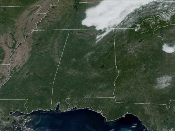
WARM WEDNESDAY: Today is dry statewide with highs in the mid 80s. We are seeing sunshine in full supply along with that beautiful cobalt blue sky. Moisture levels begin to rise tomorrow, and we will mention a chance of showers over the southern half of the state. Then, showers are possible statewide on Friday. No wash-out, but some rain is possible at times, but even these showers should be few and far between across the state. Highs will be mostly in the low 80s on these two days.
FRIDAY NIGHT LIGHTS: Dry and pleasant for the high school games Friday night; temperatures will fall through the 70s.
BIRMINGHAM ALMANAC: For October 2nd, the average high for Birmingham is 81° and the average low is 60°. The record high is 99° set in 2019, while the record low is 36° set in 1984 We average 0.12” of precipitation on this date, and the record value is 1.83” set in 1962.
ACROSS THE USA: A cold front pressing south across the northern and central Plains today will bring gusty winds creating critical fire weather for parts of the region. Red Flag Warnings and Fire Weather Watches have been issued. Dangerous heat continues in parts of the Desert Southwest through Friday. Excessive Heat Warnings are in effect for southwest Arizona into Nevada and large portion of coastal California.
THE ALABAMA WEEKEND: At this point the weekend looks warm and dry. Expect a partly to mostly sunny sky Saturday and Sunday with highs in the low 80s. And, for next week, the weather looks dry and cooler with highs dropping into the upper 70s along with lows in the 50s; feeling like fall for sure.
FOOTBALL WEATHER: Saturday UAB will host Tulane at Protective Stadium in downtown Birmingham (12:00p CT kickoff)… the sky will be mostly sunny with temperatures in the low to mid 80s.
Auburn will be on the road at Georgia (2:30p CT kickoff)… the sky will be sunny with temperatures in the low 80s through most of the game.
Alabama travels to Nashville to take on Vanderbilt (3:15p CT kickoff)… expect a sunny sky with temperatures falling from near 85 degrees at kickoff, to near 80 by the final whistle.
LEFT TURNS ONLY: A few showers are possible across East Alabama Saturday, but for now the weekend looks warm and dry for the races at the Talladega Superspeedway. Afternoon temperatures will be in the low to mid 80s, lows will be in the 60s.
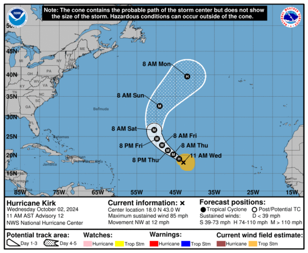
IN THE TROPICS: Kirk is now a hurricane and was located near latitude 18.0 North, longitude 43.0 West. Kirk is moving toward the northwest near 12 mph and this motion is expected over the next several days with a gradual turn more to the north-northwest by the end of the week. Maximum sustained winds have increased to near 85 mph with higher gusts. Additional strengthening is forecast, and Kirk is forecast to become a major hurricane tomorrow. The estimated minimum central pressure is 980 mb (28.94 inches).Thankfully Kirk, will turn north and remain a fish storm.
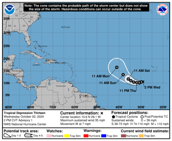
Off the African Coast, we have Invest 91-L, is now Tropical Depression 13, and should become Leslie in the coming days. The center of Tropical Depression Thirteen was located near latitude 10.6 North, longitude 29.1 West. The depression is moving toward the west near 7 mph and a general westward motion is expected for the next day or so followed by a turn more west-northwestward by the weekend. Gradual strengthening is forecast, and the depression could become a tropical storm by tonight, and is expected to become a hurricane by the weekend. The estimated minimum central pressure is 1006 mb (29.71 inches). This storm will also turn north and remain a fish storm.
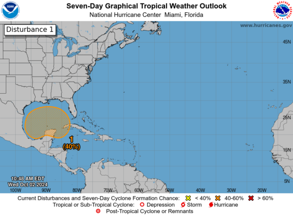
Closer to home, a broad trough of low pressure is producing a large area of disorganized showers and thunderstorms from the southwestern Caribbean Sea into the southern Gulf of Mexico. Environmental conditions could support some gradual development of this system, and a tropical depression could form over the weekend as the broader disturbance moves fully into the Gulf of Mexico. Interests along the U.S. Gulf Coast should continue to monitor the progress of this system. Formation chance through 7 days…medium…40 percent. No issues with this system until late weekend or early next week. This is when it could become a system and impact some locations along the Gulf Coast, but these impacts could be anywhere from Texas to Florida.
Next name up is Milton.
WORLD TEMPERATURE EXTREMES: Over the last 24 hours, the highest observation outside the U.S. was 113.0F at Hermosillo, Mexico. The lowest observation was -98.5F at Vostok, Antarctica.
CONTIGUOUS TEMPERATURE EXTREMES: Over the last 24 hours, the highest observation was 117F at Indio and Palm Springs, CA. The lowest observation was 19F at Grand Lake, CO.
Category: Alabama's Weather, ALL POSTS, Social Media, Tropical
About the Author (Author Profile)
Macon, Georgia Television Chief Meteorologist, Birmingham native, and long time Contributor on AlabamaWX. Stormchaser. I did not choose Weather, it chose Me. College Football Fanatic. @Ryan_StinnetSubscribe
If you enjoyed this article, subscribe to receive more just like it.


