
Midday Nowcast: Welcome to October; Keeping an Eye on the Tropics
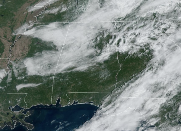
It is a mainly dry, warm day with only a small risk of a shower over North and West Alabama this afternoon. Tomorrow will be dry statewide with highs in the mid 80s. Moisture levels begin to rise Thursday, and we will mention a chance of showers over the southern half of the state. Then, showers are possible statewide on Friday. No wash-out, but some rain is possible at times, but even these showers should be few and far between across the state. Highs will be mostly in the low 80s on these two days.
BIRMINGHAM ALMANAC: For October 1st, the average high for Birmingham is 82° and the average low is 60°. The record high is 99° set in 2019, while the record low is 40° set in 1972. We average 0.12” of precipitation on this date, and the record value is 1.83” set in 1906. By the end of the month, our average high will drop to 70° and our average low drops to 48°. Additionally, October is statistically our driest month of the year in Alabama and on average, Birmingham receives 2.94” of rain. The wettest October on record was 1995 when 11.90” fell on the city, mostly due to Hurricane Opal. The driest October for Birmingham was 1924, when no rain was reported in the city.
ACROSS THE USA: Locally heavy rainfall will affect portions of the mid-Atlantic today as residual tropical moisture moves through the region. For parts of Florida, increasing coverage of showers and thunderstorms may produce heavy rainfall along with warm and humid conditions. The heat will continue across portions of the West with new records expected. The Plains and northern Rockies, fire weather concerns today.
THE ALABAMA WEEKEND: At this point the weekend looks warm and dry. Expect a partly to mostly sunny sky Saturday and Sunday with highs in the low 80s. And, for next week, the weather looks dry and cooler with highs dropping into the upper 70s along with lows in the 50s; feeling like fall for sure.
LEFT TURNS ONLY: A few showers are possible across East Alabama Saturday, but for now the weekend looks warm and dry for the races at the Talladega Superspeedway. Afternoon temperatures will be in the low to mid 80s, lows will be in the 60s.
IN THE TROPICS: Issac and Joyce are no more; Tropical Storm Kirk and is forecast to become a major hurricane by the end of the week, but will turn north and remain a fish storm.
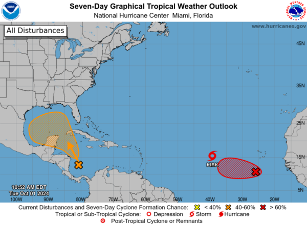
Off the African Coast, we have Invest 91-L, which are showers and thunderstorms that continue to show signs of organization in association with a broad area of low pressure located a few hundred miles south-southwest of the Cabo Verde Islands. Environmental conditions appear conducive for further development of this system, and a tropical depression is expected to form during the next couple of days while it moves slowly westward over the eastern tropical Atlantic.Formation chance: High…90 percent.
Closer to home, disorganized showers and thunderstorms located over the southwestern Caribbean Sea are associated with a trough of low pressure. Environmental conditions could support some gradual development of this system, and a tropical depression could form towards the end of this week or this weekend while it moves generally northwestward over the northwestern Caribbean Sea and into the Gulf of Mexico. Interests along the U.S. Gulf Coast should continue to monitor the progress of this system. Formation chance through 7 days…medium…40 percent. Way too early to know where this system is going or potential impacts. It is just something to watch as we approach the weekend.
Next names up are Leslie and Milton.
WORLD TEMPERATURE EXTREMES: Over the last 24 hours, the highest observation outside the U.S. was 112.1F at Rivadavia, Argentina. The lowest observation was -94.0F at Vostok, Antarctica.
CONTIGUOUS TEMPERATURE EXTREMES: Over the last 24 hours, the highest observation was 111F at Death Valley, CA. The lowest observation was 16F at Peter Sinks, UT.
Category: Alabama's Weather, ALL POSTS, Social Media
About the Author (Author Profile)
Macon, Georgia Television Chief Meteorologist, Birmingham native, and long time Contributor on AlabamaWX. Stormchaser. I did not choose Weather, it chose Me. College Football Fanatic. @Ryan_StinnetSubscribe
If you enjoyed this article, subscribe to receive more just like it.


