
Midday Nowcast: A Mix of Sun and Clouds; The Atlantic is Very Active
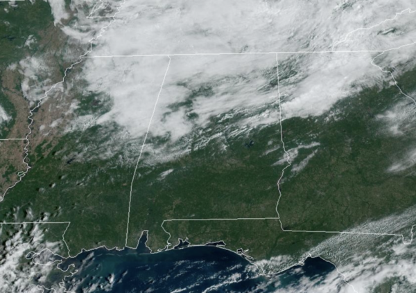
THE FINAL DAY OF SEPTEMBER: Today is a warm day with a partly sunny sky; again we have the chance of a few isolated showers over the northern third of the state, but most locations will remain dry. Highs will be in the low to mid 80s.
BIRMINGHAM ALMANAC: For September 25th, the average high for Birmingham is 82° and the average low is 61°. The record high is 98° set in 2019, while the record low is 37° set in 1967. We average 0.13” of precipitation on this date, and the record value is 2.86” set in 1915.
ACROSS THE USA: Strong winds, low humidity and dry fuels may allow for a rapid spread of fires across a large portion of the Central/Northern Plains today. For the Southwest into lower elevations of California, extreme heat will persist the next several days where new daily records are expected. For portions of the mid-Atlantic, pockets of heavy rainfall are expected today with isolated incidences of flooding.
HELLO OCTOBER: The weather doesn’t change much tomorrow; a dry, warm day with only a small risk of a shower over North Alabama. And, Wednesday will be dry statewide with highs in the mid 80s. Moisture levels begin to rise Thursday, and we will mention a chance of showers over the southern half of the state. Then, showers are possible statewide on Friday. This won’t be a wash-out, but some rain is possible at times, but these showers should be few and far between for most locations. Highs will be mostly in the low 80s on these two days.
THE ALABAMA WEEKEND: At this point the weekend looks warm and dry. Expect a partly to mostly sunny sky Saturday and Sunday with highs in the low 80s. And, for next week, the weather looks dry and cooler with highs dropping into the upper 70s along with lows in the 50s; feeling like fall for sure.
LEFT TURNS ONLY: A few showers are possible across East Alabama Saturday, but for now the weekend looks warm and dry for the races at the Talladega Superspeedway. Afternoon temperatures will be in the low to mid 80s, lows will be in the 60s.
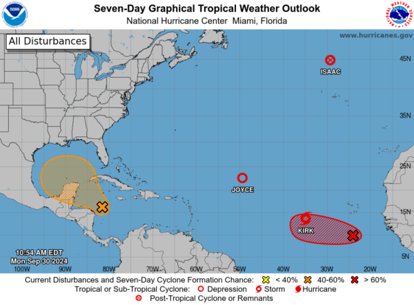
IN THE TROPICS: The Atlantic basin is active today. Here a breakdown on the action: Isaac has become post-tropical. Joyce is a weak tropical depression in the middle of the Atlantic far from land; it dissipates later today.
Tropical Depression 12 is now Kirk and is forecast to become a major hurricane by the end of the week. But, it will turn north and remain a fish storm.
Off the African Coast, showers and thunderstorms have increased in association with a tropical wave located a few hundred miles south of the Cabo Verde Islands. Upper-level winds are forecast to become more conducive for gradual development, and a tropical depression is likely to form in a few days while it moves slowly westward over the eastern tropical Atlantic. Formation chance through 7 days…high…80 percent.
Finally, in the Western Caribbean Sea and Gulf of Mexico, a large and disorganized area of low pressure located over the western and southwestern Caribbean Sea is producing some shower and thunderstorm activity. Environmental conditions could become conducive for gradual development, and a tropical depression could form in a few days while the system is over the southern Gulf of Mexico or northwestern Caribbean Sea. While interests in the northwestern Caribbean Sea and along the U.S. Gulf Coast should continue to monitor the progress of this system, the timetable for potential development has shifted later toward late week or this weekend. Formation chance through 7 days…medium…40 percent.
Next names up are Leslie and Milton.
WORLD TEMPERATURE EXTREMES: Over the last 24 hours, the highest observation outside the U.S. was 111.9F at Ejido Nuevo León, Mexico. The lowest observation was -94.0F at Dome C, Antarctica.
CONTIGUOUS TEMPERATURE EXTREMES: Over the last 24 hours, the highest observation was 113F at Phoenix, AZ. The lowest observation was 17F at Frenchgien, OR.
Category: Alabama's Weather, ALL POSTS, Social Media
About the Author (Author Profile)
Macon, Georgia Television Chief Meteorologist, Birmingham native, and long time Contributor on AlabamaWX. Stormchaser. I did not choose Weather, it chose Me. College Football Fanatic. @Ryan_StinnetSubscribe
If you enjoyed this article, subscribe to receive more just like it.


