
Tropical Depression 12 Forms, May Become Kirk…Isaac and Joyce Still Hanging On
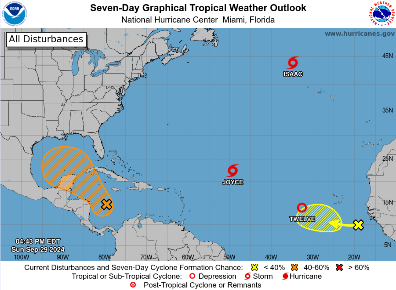
The tropics are heating up with multiple systems currently under observation. Hurricane Isaac continues to churn in the Atlantic, located several hundred miles northwest of the Azores. The storm has weakened, with maximum sustained winds now at 70 mph, and is expected to transition into an extratropical cyclone by Monday. Although Isaac poses no direct threat to land, large swells are impacting the Azores, creating dangerous surf and rip currents.
Meanwhile, Tropical Storm Joyce, situated over the central Atlantic, is gradually weakening. With maximum sustained winds of 40 mph, Joyce is moving northwestward at 6 mph. The storm is expected to weaken further and become a tropical depression by Monday, transitioning into a remnant low by midweek. While Joyce doesn’t pose a land threat, it continues to generate strong winds and rough seas.
The National Hurricane Center has also christened a new system, Tropical Depression 12 (formerly AL90). Located 585 miles west-southwest of the Cabo Verde Islands, TD12 is expected to strengthen into a tropical storm and potentially a hurricane later this week. Environmental conditions are highly favorable, and the depression could intensify significantly as it moves west-northwestward. Forecasts indicate it may become a major hurricane by the weekend, though it currently poses no immediate land threat.
In addition to the active systems already in the Atlantic, a low-latitude tropical wave near the coast of western Africa is beginning to show signs of gradual development. While current shower and thunderstorm activity remains limited, upper-level winds are expected to become more favorable in the coming days. As the system moves slowly westward or west-northwestward across the eastern Atlantic, conditions could allow for better organization. The National Hurricane Center gives this system a low 30% chance of formation over the next seven days, but it is one to watch as it tracks through the tropical Atlantic.
Finally, eyes are on the western Caribbean, where a broad area of low pressure could develop into a tropical depression by midweek. This system has a 50% chance of formation over the next seven days and could pose a significant threat to the northern Gulf Coast by the weekend. All interests from the Caribbean to the Gulf Coast should closely monitor its progress.
Category: Alabama's Weather, ALL POSTS, Social Media, Tropical
About the Author (Author Profile)
Bill Murray is the President of The Weather Factory. He is the site's official weather historian and a weekend forecaster. He also anchors the site's severe weather coverage. Bill Murray is the proud holder of National Weather Association Digital Seal #0001 @wxhistorianSubscribe
If you enjoyed this article, subscribe to receive more just like it.


