Late Morning Update: Radar Updates & a Busy Tropical Outlook
CONDITIONS BEFORE MIDDAY & WHAT TO EXPECT
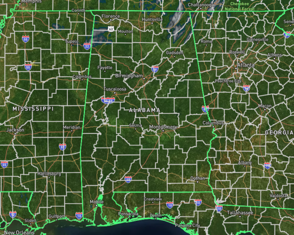
10:20 AM Update: Right now, radar is showing some light rain over northern Alabama, including spots like Russellville, Red Bay, Fort Payne, Scottsboro, Rainsville, Stevenson, and Bridgeport. As for the rest of the state, things are looking clear at the moment. The northern half of Alabama is pretty socked in with clouds, with a few breaks here and there, while the southern half is enjoying some nice, bright sunshine—we could all use a little of that after the past few days!
Under the clouds, temperatures are still in the 60s, but the sunny spots are already warming up into the 70s. Montgomery is the warm spot right now, sitting at 76 degrees, while Haleyville is the cool spot at 61. Birmingham is at 65, Tuscaloosa at 68, and Auburn is already up to 74.
As we warm up through the rest of the morning and into the afternoon, we might see a few more showers pop up, thanks to the lingering influence of the remnants of Helene to our north. The best chance for these, though small, will be along and north of I-20. The further south you go, especially from Demopolis down to Selma, Montgomery, and Auburn, the better your chances of staying dry. Highs today will range from the lower 70s in the north to the mid-80s in the south.
As for tonight and overnight, it’s the same story. A few isolated showers are possible for North and Central Alabama, while South Alabama stays dry. Lows will dip into the upper 50s to mid-60s.
WEATHER FOR COLLEGE FOOTBALL
At Protective Life Stadium for UAB, expect partly to mostly cloudy skies throughout the game. There’s a small chance for a light shower, but the overall risk is low. Temperatures will start in the upper 60s and climb to the low 70s by the final whistle. Winds will be coming out of the west at 5-15 mph, with gusts up to 25 mph possible.
Down at Jordan-Hare Stadium for Auburn, skies will stay mostly cloudy this afternoon, and it’ll be breezy at times. Kickoff temps will be in the upper 70s, dropping slightly to the mid-70s by the end of the game. A stray shower can’t be ruled out, but rain chances are very slim.
And finally, at Bryant-Denny Stadium for Alabama, tonight’s weather will feature mostly cloudy skies with a very slight chance for an isolated shower. Winds will be light at 5-10 mph, with temperatures starting in the low 70s at kickoff and dipping into the mid-60s by game’s end.
NEARLY THE SAME CONDITIONS FOR SUNDAY
As the remnants continue lingering just to our north, we’ll still have a small chance of seeing a few isolated to scattered showers in the same spots as yesterday. Otherwise, northern areas will stay mostly cloudy, while the southern half will enjoy partly to mostly sunny skies. Highs today will range from the upper 70s in the north to the mid-80s down south.
THE TROPICS
Western Caribbean Sea and Gulf of Mexico
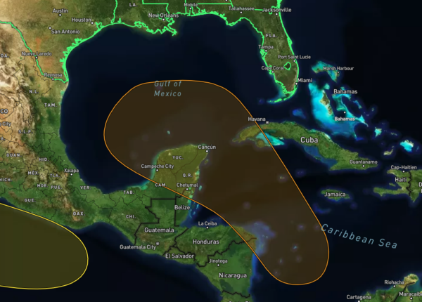
We’re keeping an eye on the western Caribbean Sea, where an area of low pressure could form in the next few days. As this system moves northwest, conditions are expected to become more favorable for development. There’s a chance that a tropical depression could form by the middle to later part of next week as the system moves into the Gulf of Mexico.
Right now, the chances of formation in the next 48 hours are low, around 0 percent, but looking ahead to the next 7 days, the chances increase to around 40 percent.
Eastern and Central Tropical Atlantic
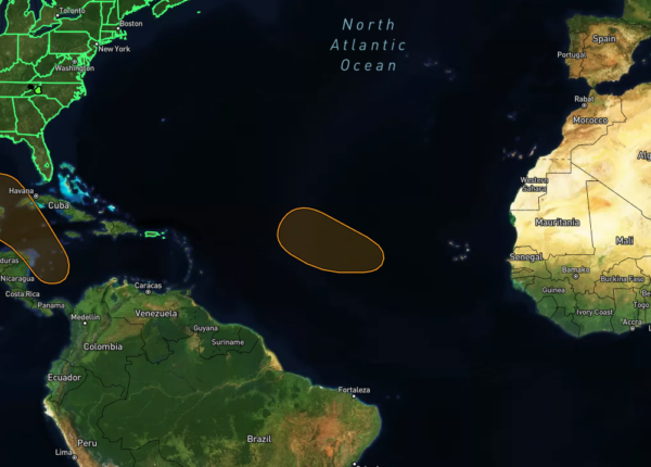
We’re tracking a broad area of low pressure tied to a tropical wave near the Cabo Verde Islands. Right now, it’s producing disorganized showers and thunderstorms, but the environment looks favorable for gradual development. There’s a chance we could see a tropical depression form early to mid-next week as this system moves west, then turns northwest across the eastern and central tropical Atlantic.
For the next 48 hours, the formation chances are low at around 20 percent, but over the next 7 days, those chances rise to 60 percent.
Tropical Storm Joyce
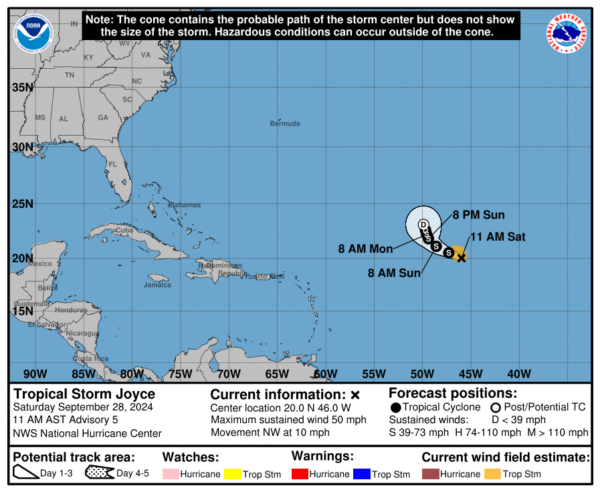
Joyce is battling some moderate-to-strong vertical wind shear right now. After managing to fire off a decent burst of thunderstorms overnight, we’re seeing southerly wind shear pulling most of that activity to the north, which has partially exposed the storm’s low-level circulation. However, there’s a new burst of storms developing closer to the center. Satellite data has clocked a few wind speeds just over 40 knots in the northwest part of the storm, so we’re keeping the intensity at 45 knots for this advisory.
Joyce is continuing to move northwest at about 9 knots, sitting on the south side of a weakening subtropical ridge. Over the next day or so, it’ll keep heading in this general direction. But as a deep trough in the northern Atlantic digs in and breaks down that ridge, Joyce is expected to slow down and shift more toward the north early next week. Now, unlike a lot of storms, Joyce isn’t expected to fully curve northward. Instead, it should remain a shallow system and drift north-northwest until it fizzles out, which is pretty much in line with our previous forecast.
As for the conditions around Joyce, they’re not looking too favorable for much strengthening. The SHIPS model is showing that wind shear will stay pretty strong, which could pull dry air into the storm’s circulation. So, we’re not expecting any major changes in Joyce’s strength today, and we’ll likely see a steady weakening through early next week. Joyce is still on track to become a remnant low by day 3, but now, some models suggest it could weaken into a trough and fully dissipate by day 4, and that’s reflected in our updated forecast.
Hurricane Isaac
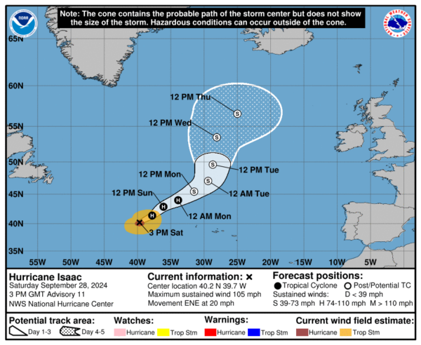
Isaac’s strengthening trend from the past day seems to have leveled off. The storm still has a well-defined eye and looks pretty symmetrical, although some dry air is creeping in from the southwest. Right now, intensity estimates range from 77 to 93 knots, and we’re holding the intensity at 90 knots, in line with the Dvorak classification from TAFB at 5.0. We’ve also adjusted the wind radii based on data from the ASCAT-B pass earlier this morning.
Isaac is already sitting over cooler waters and will encounter even lower sea surface temperatures in the next day or two, along with increasingly hostile wind shear. So, it looks like Isaac has likely peaked in intensity, and we expect gradual weakening to kick in today, speeding up as we move through the weekend. This weakening will line up with Isaac transitioning into an extratropical system, which, according to global models, should be complete in about 48 hours. Our intensity forecast remains unchanged from the last one and closely matches the consensus models for this period.
Isaac is currently moving east-northeast at about 17 knots. As the storm moves near a mid- to upper-level ridge over the next day or so, its steering flow will decrease, causing Isaac to slow down while it’s still in its warm-core phase. Once it begins its extratropical transition, we should see it turn more toward the north as a shortwave trough digs in from the west. Our track forecast remains unchanged for the next 48 hours, but beyond that, we’ve shifted the track slightly to the right to better align with the latest model guidance.
Category: Alabama's Weather, ALL POSTS, Social Media, Tropical


