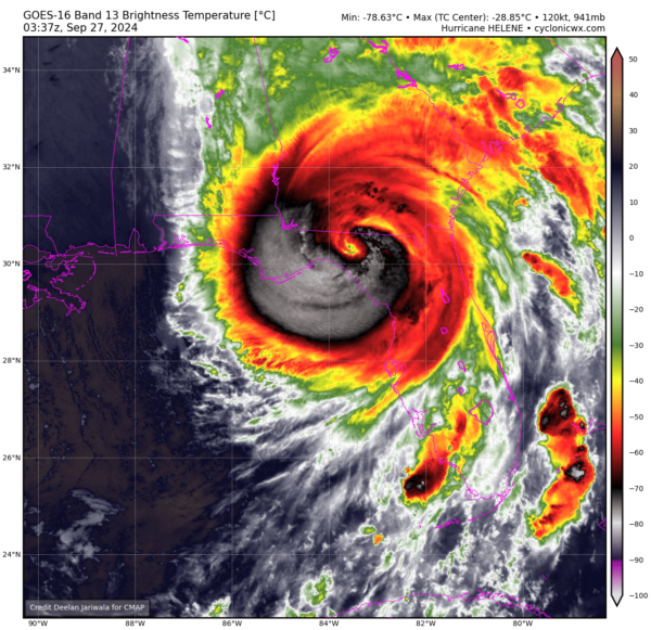
What Southeast Alabama, Southwest Georgia, and the Big Bend Area of Florida Can Expect Overnight
This evening, we’re closely monitoring the impact of Major Hurricane Helene, which is currently making landfall along the coast of Taylor County, Florida. Conditions are expected to worsen overnight, particularly along the I-75 corridor in South Georgia, so it’s crucial for residents to hunker down and prioritize safety.
Currently, Storm Surge Warnings and Hurricane Warnings are in effect for several coastal counties, including Dixie, Franklin, and Gulf, along with a Hurricane Warning extending inland to many counties such as Baker and Brooks. Additionally, a Tropical Storm Warning is active for various areas including Calhoun and Houston counties.
As of now, Helene is positioned about 10 miles south-southeast of the Aucilla River, with maximum sustained winds of 140 mph, moving north-northeast at 24 mph. We’ve already seen wind gusts of up to 102 mph reported offshore, and it’s important to remember that tropical-storm force winds extend far from the center of this massive storm.
Expect significant impacts from Helene, including dangerous high winds, devastating storm surge along the coast of Apalachee Bay, and potentially catastrophic flooding due to heavy rainfall. Areas could see 5 to 10 inches of rain, with local totals reaching up to 15 inches, leading to flash flooding.
The wind threat is serious—prepare for structural damage, prolonged power outages, and blocked roads due to debris. If an Extreme Wind Warning is issued for your area, it indicates winds could exceed 115 mph, so seek shelter in an interior room away from windows.
Storm surge is another major concern, particularly along the coasts of Dixie and Taylor counties. We’re already seeing tide levels rise significantly, with inundation levels potentially reaching 15 to 20 feet in some areas.
Stay alert for tornado warnings as well, as a few tornadoes could develop along and east of Helene’s path.
As we navigate these dangerous conditions, remember to stay indoors, listen for updates, and ensure you have emergency supplies at the ready. Don’t venture outside during the eye of the storm, as conditions can change rapidly.
Your safety is our priority. We’ll continue to provide updates as the situation unfolds. Stay safe and take all necessary precautions.
Category: Alabama's Weather, ALL POSTS, Severe Weather, Social Media, Tropical


