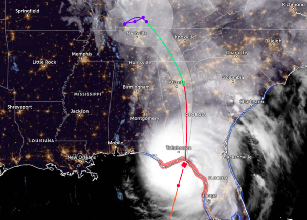
Landfall Imminent; Helene Approaches the Big Bend of Florida
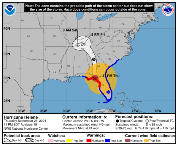
Hurricane Helene is rapidly nearing landfall in the Florida Big Bend area, bringing catastrophic storm surge and life-threatening winds. As of the latest advisory at 11 PM EDT on September 25, 2024, Helene is located approximately 75 miles northwest of Cedar Key and about 40 miles southeast of Tallahassee, with maximum sustained winds reaching 140 mph (220 km/h). The storm is currently moving north-northeast at 24 mph (39 km/h) and is expected to make landfall soon.
A Storm Surge Warning is in effect from Mexico Beach eastward to Flamingo and includes Tampa Bay and Charlotte Harbor. A Hurricane Warning is in effect from Anclote River to Mexico Beach, while a Hurricane Watch is active from Englewood to Anclote River, including Tampa Bay. Additionally, Tropical Storm Warnings extend across the Florida Keys and parts of the Gulf Coast.
The expected storm surge could inundate areas near the coast with water levels rising as much as 20 feet in some locations, particularly from Carrabelle to the Suwannee River. Hurricane-force winds extend up to 60 miles from the center, and tropical-storm-force winds reach up to 310 miles, leading to hazardous conditions across much of central and northern Florida.
As Helene moves inland, it is anticipated to weaken but will still pose significant threats, including heavy rainfall (6 to 12 inches, with isolated totals up to 20 inches) that could result in flash flooding and landslides, particularly in the southern Appalachians. Additionally, there remains a risk of tornadoes across parts of Florida, Georgia, and the Carolinas.
Residents in affected areas should take immediate precautions to protect life and property and follow local officials’ instructions. Stay tuned for updates from the National Hurricane Center and your local weather services.
Key Messages:
Storm Surge Threat: Catastrophic and deadly storm surge is currently impacting the Florida Big Bend coast, with inundation levels potentially reaching up to 20 feet above ground. Other areas along Florida’s west coast are also at risk of life-threatening surge.
Hurricane-Force Winds: The eyewall of Helene is producing destructive hurricane-force winds that will extend inland into northern Florida and southern Georgia.
Inland Wind Damage: Strong wind gusts are anticipated to reach well into Georgia and the Carolinas tonight, particularly in the higher elevations of the southern Appalachians. Residents should prepare for prolonged power outages and use generators safely to avoid carbon monoxide poisoning.
Flash Flooding Risks: Catastrophic flash and urban flooding, along with significant landslides, are expected across the southern Appalachians through Friday. Northwestern and northern Florida, as well as the Southeast, may experience considerable flooding, with widespread river flooding likely.
Category: ALL POSTS, Severe Weather, Social Media, Tropical


