Rain, Wind For East Alabama Tonight; Dry Weekend Ahead
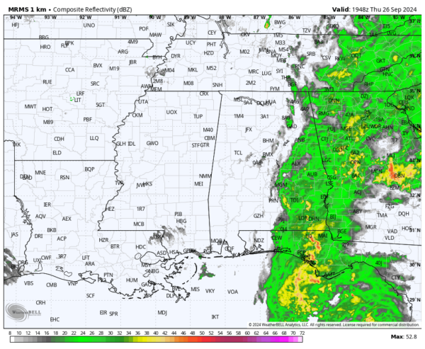
WET, WINDY NIGHT FOR EAST ALABAMA: Rain covers much of East and Southeast Alabama this afternoon ahead of Hurricane Helene, which will make landfall tonight along the Big Bend coast of Florida south of Tallahassee. Rain will continue over the eastern half of Alabama tonight, possibly heavy at times. Winds will increase as well, and gusts to 35/40 mph are possible east of I-65. Gusts could reach 50 mph in spots around the southeast corner of the state around Dothan. West Alabama will be mostly dry tonight.
We should mention there is no tornado threat for Alabama tonight; that risk is east of the state.
Rain will diminish by daybreak tomorrow as Helene weakens and moves northward.
For the southern 2/3 of Alabama, tomorrow will be a dry day with a partly sunny sky. However, showers are possible tomorrow afternoon and tomorrow night over North Alabama thanks to an upper low just to the north. High resolution models suggest winds will ramp up over the northern counties of the state as well tomorrow afternoon, with gusts to 30/35 mph possible.
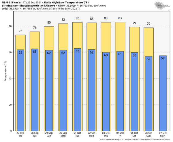
THE ALABAMA WEEKEND: The weather looks dry for most of the state; the sky will be partially sunny Saturday and Sunday with highs in the 77-82 degree range. We can’t rule out a shower or two near the Tennessee state line, but even there most places will be dry.
And, next week looks rain-free with highs in the low 80s.
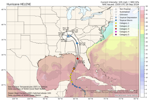
HELENE: Hurricane Helene is now a major, category three hurricane with winds of 120 mph. The circulation center is about 160 miles west/southwest of Tampa; it is moving to the north/northeast at 20 mph. Landfall comes tonight south of Tallahassee. A 15-20 foot storm surge is expected along and east of the landfall point from Carrabelle to the Suwannee River.
FOOTBALL WEATHER: For the high school games across Alabama tomorrow night… most stadiums will be dry, but the exception is over the northern third of the state where showers are possible. We should also note it will be windy over North Alabama, with gusts to 30/35 mph possible. Temperatures will be in the 70s.
Saturday UAB hosts Navy (11a CT kickoff at Protective Stadium)… the sky will be partly sunny; temperatures will rise from near 75 at kickoff to 79 by the final whistle.
Auburn hosts Oklahoma Saturday afternoon at Jordan-Hare Stadium (2:30p CT kickoff)… expect a partly sunny sky with temperatures in the 77-81 degree range.
Alabama will host Georgia at Bryant-Denny Stadium Saturday evening (6:30p CT kickoff)…the sky will be mostly fair with temperatures falling through the 70s.
ON THIS DATE IN 1955: On this date, the Atlantic reconnaissance aircraft, ”Snowcloud Five” went down while investigating Hurricane Janet and was never heard from again. Lt. Comdr. Windham with a crew of 8 and two newspapermen reported that they were about to begin penetrating the central core of the hurricane. Hurricane Janet made landfall at peak intensity near Chetumal, Mexico on September 29th. Janet’s landfall as a Category 5 hurricane on the Yucatán Peninsula was the first recorded instance that a storm of such intensity in the Atlantic made landfall on a continental mainland; prior to Janet, landfalls of Category 5 intensity were only known to have taken place on islands.
Look for the next video briefing here by 6:00 a.m. tomorrow…
Category: Alabama's Weather, ALL POSTS, Weather Xtreme Videos


