10pm Update on Hurricane Helene
HELENE EXPECTED TO BRING CATASTROPHIC WINDS AND STORM SURGES TO THE NORTHEASTERN GULF COAST.
PREPARATIONS TO PROTECT LIFE AND PROPERTY SHOULD BE RUSHED TO COMPLETION.
SUMMARY OF 1000 PM CDT…0300 UTC…INFORMATION
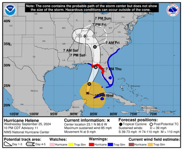
- Location: 23.1N 86.6W
- About: 425 miles (680 km) SW of Tampa, Florida; 465 miles (750 km) SSW of Apalachicola, Florida
- Maximum Sustained Winds: 85 mph (140 km/h)
- Present Movement: North (360 degrees) at 9 mph (15 km/h)
- Minimum Central Pressure: 972 mb (28.71 inches)
WATCHES AND WARNINGS
Changes with this advisory:
- The government of Mexico has discontinued the Hurricane and Tropical Storm Warnings for the Yucatan Peninsula of Mexico.
- The government of Cuba has discontinued the Hurricane Watch for the Cuban province of Pinar del Rio.
SUMMARY OF WATCHES AND WARNINGS IN EFFECT:
- Storm Surge Warning:
- Mexico Beach eastward and southward to Flamingo
- Tampa Bay
- Charlotte Harbor
- Anclote River to Mexico Beach
- Englewood to Anclote River, including Tampa Bay
- Florida Keys, including the Dry Tortugas
- Flamingo to Anclote River, including Tampa Bay
- West of Mexico Beach to the Okaloosa/Walton County Line
- Flamingo northward to Little River Inlet
- Lake Okeechobee
- Cuban provinces of Artemisa, Pinar del Rio, and the Isle of Youth
DISCUSSION AND OUTLOOK
At 1000 PM CDT (0300 UTC), the center of Hurricane Helene was located near latitude 23.1 North, longitude 86.6 West. Helene is moving toward the north at 9 mph (15 km/h). A northward or north-northeastward motion at a faster forward speed is expected over the next 36 hours. Helene is forecast to cross the eastern Gulf of Mexico tonight and Thursday and reach the Florida Big Bend coast Thursday evening. After landfall, it will slow down over the Tennessee Valley on Friday and Saturday.
Maximum sustained winds: 85 mph (140 km/h), with higher gusts. Strengthening is expected, and Helene is forecast to be a major hurricane when it reaches the Florida Big Bend coast Thursday evening. Weakening is expected after landfall, but strong, damaging winds will extend far inland.
Hurricane-force winds: Extend outward up to 35 miles (55 km) from the center.
Tropical-storm-force winds: Extend outward up to 345 miles (555 km).
Minimum Central Pressure: 972 mb (28.71 inches).
HAZARDS AFFECTING LAND
STORM SURGE:
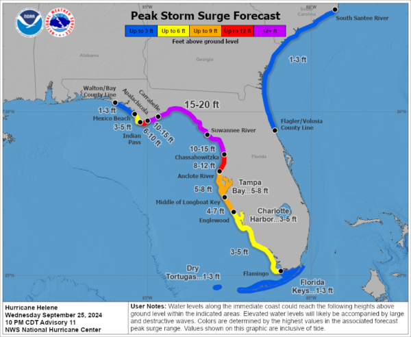
The combination of life-threatening storm surge and high tide will cause flooding in normally dry areas near the coast. Water could reach the following heights above ground:
- 15-20 ft: Carrabelle, FL to Suwannee River, FL
- 10-15 ft: Apalachicola, FL to Carrabelle, FL; Suwannee River, FL to Chassahowitzka, FL
- 8-12 ft: Chassahowitzka, FL to Anclote River, FL
- 5-8 ft: Tampa Bay; Anclote River, FL to Middle of Longboat Key, FL
- 4-7 ft: Middle of Longboat Key, FL to Englewood, FL
- 3-5 ft: Englewood, FL to Flamingo, FL; Charlotte Harbor; East of Mexico Beach, FL to Indian Pass, FL
WIND:
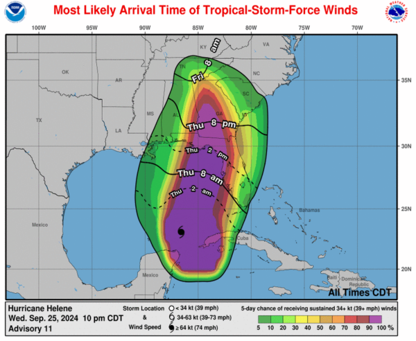
Hurricane conditions are expected within the U.S. hurricane warning area late Thursday, with tropical storm conditions starting in southern Florida tonight and moving northward into Georgia and South Carolina by Thursday night.
RAINFALL:
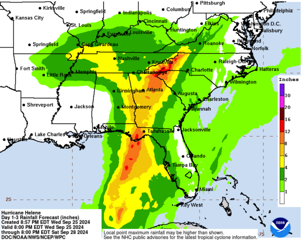
Helene is expected to bring 4 to 8 inches of rain over western Cuba, the Cayman Islands, and the northeast Yucatan Peninsula, with isolated totals up to 12 inches. Over the Southeastern U.S., 6 to 12 inches are expected, with isolated totals of 18 inches, leading to catastrophic flooding and landslides in higher terrains.
TORNADOES:
A tornado or two may occur tonight over Florida, with an increased risk spreading to Georgia and South Carolina on Thursday.
SURF:
Swells generated by Helene will affect the southern coast of Cuba and Yucatan, spreading to Florida’s west coast and the northeastern Gulf Coast by Thursday.
Category: Alabama's Weather, ALL POSTS, Severe Weather, Social Media, Tropical


