10AM CDT Helene Update: Hurricane Status Reached; Intensification Underway
Helene is now officially a hurricane. We have been forecasting this storm for many days now, and it has now reached wind speeds of 80 mph.
Here are the current facts from the NHC as of 10AM CDT:
SUMMARY OF 1000 AM CDT…1500 UTC…INFORMATION
———————————————–
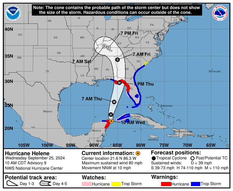
LOCATION…21.6N 86.3W
ABOUT 85 MI…135 KM NNE OF COZUMEL MEXICO
ABOUT 500 MI…810 KM SSW OF TAMPA FLORIDA
MAXIMUM SUSTAINED WINDS…80 MPH…130 KM/H
PRESENT MOVEMENT…NNW OR 330 DEGREES AT 10 MPH…17 KM/H
MINIMUM CENTRAL PRESSURE…979 MB…28.91 INCHES
WATCHES AND WARNINGS
——————–
CHANGES WITH THIS ADVISORY:
The Tropical Storm Warning has been extended northward along the
coasts of Georgia and South Carolina to South Santee River, and
westward along the Florida Gulf coast to the Okaloosa/Walton County
Line.
A Storm Surge Watch has been issued from Mexico Beach to Indian
Pass, Florida.
A Tropical Storm Watch has been issued along the coast of South
Carolina north of South Santee River to Little River Inlet.
SUMMARY OF WATCHES AND WARNINGS IN EFFECT:
A Storm Surge Warning is in effect for…
* Indian Pass southward to Flamingo
* Tampa Bay
* Charlotte Harbor
A Hurricane Warning is in effect for…
* Anclote River to Mexico Beach
* Cabo Catoche to Tulum, Mexico including Cozumel
A Storm Surge Watch is in effect for…
* West of Indian Pass to Mexico Beach
A Hurricane Watch is in effect for…
* Cuban province of Pinar del Rio
* Englewood to Anclote River, including Tampa Bay
A Tropical Storm Warning is in effect for…
* Florida Keys, including the Dry Tortugas
* Flamingo to Anclote River, including Tampa Bay
* West of Mexico Beach to the Okaloosa/Walton County Line
* Flamingo northward to South Santee River
* Lake Okeechobee
* Rio Lagartos to Cabo Catoche, Mexico
* Cuban provinces of Artemisa, Pinar del Rio, and the Isle of Youth
A Tropical Storm Watch is in effect for…
* North of South Santee River to Little River Inlet
As of 10AM CDT, the minimum pressure in the central region of the storm has dropped to 979 mb. The forecasted track of the storm remains the same as the last advisory, with the Big Bend region of Florida set to be on the receiving end of landfall. Most of the Florida Coast is now under either a Tropical Storm or Hurricane Warning.
We are expecting devastating effects to the Florida Coastline. The NHC is still forecasting a category 3 storm at landfall, with winds around 115 mph. Another issue with this storm is the speed at which it is moving. It will be moving inland so quickly that hurricane and tropical storm winds will likely be felt across much of the Southeastern United States.
Right now, tropical storm force winds can be felt up to 275 miles away from the center of the storm. This is a very large system. It will continue to hold this size until landfall, before it slowly begins to weaken.
Landfall is expected to occur tomorrow evening, potentially around 7pm CDT. Tropical storm force winds will arrive earlier than that, and hurricane winds will begin to be felt closer to the time of landfall.
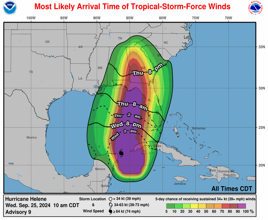
Arrival Time of Winds
Upon landfall, high storm surge and damaging winds are expected. Right now, the highest storm surge is predicted to occur in the Big Bend region, with totals of 10-15 ft possible. This will lead to major flooding along most of the Florida Coastline.
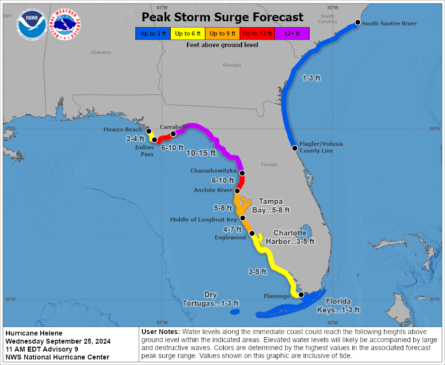
Peak Storm Surge Forecast
This system will bring copious amounts of rainfall, and this rain will be felt across the Southeast. With this comes a major risk of flash flooding, especially near the center of the storm as it moves inland. In Alabama, up to 6-8 inches of rain could fall in the eastern side of the state. This will bring a high risk of flash flooding to the south and eastern areas of Alabama.
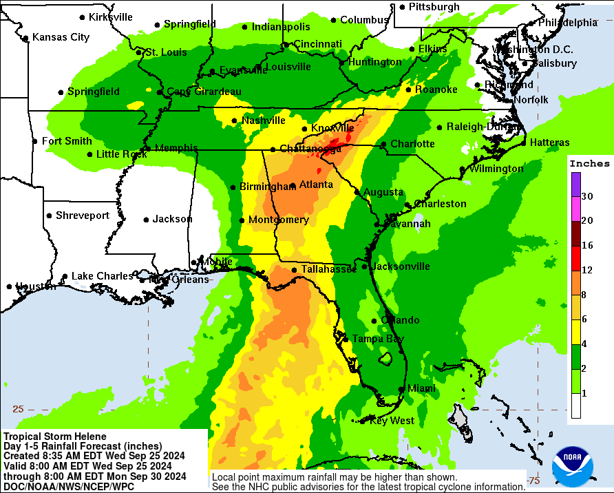
Rainfall Amounts from Helene
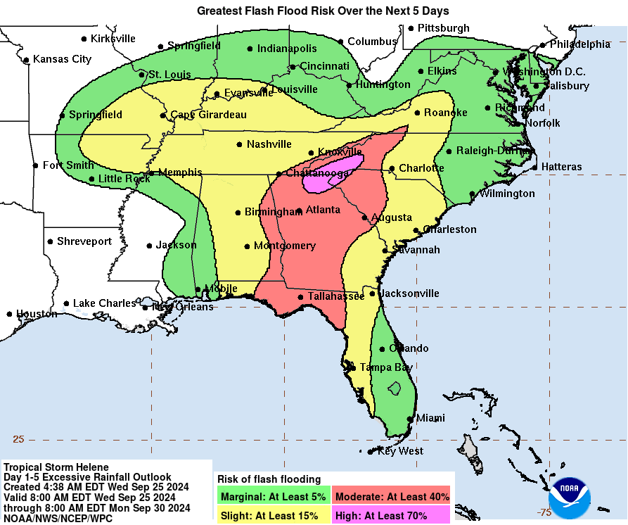
Likelihood of Flash Flooding from Helene
Later today, we will make a post specific to impacts that may be felt in Alabama. Stay tuned.
Category: ALL POSTS, Social Media, Tropical
About the Author (Author Profile)
Scott is a senior at Mississippi State University studying professional and broadcast meteorology.Subscribe
If you enjoyed this article, subscribe to receive more just like it.


