Midday Nowcast: Helene Now a Hurricane; Some Alabama Impacts
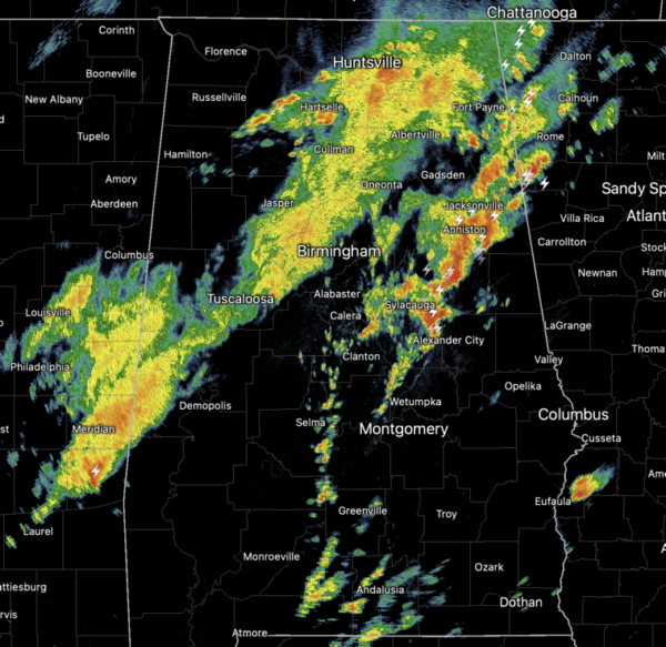
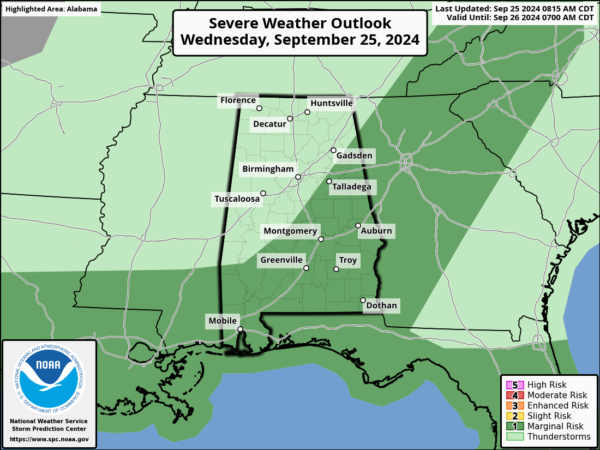
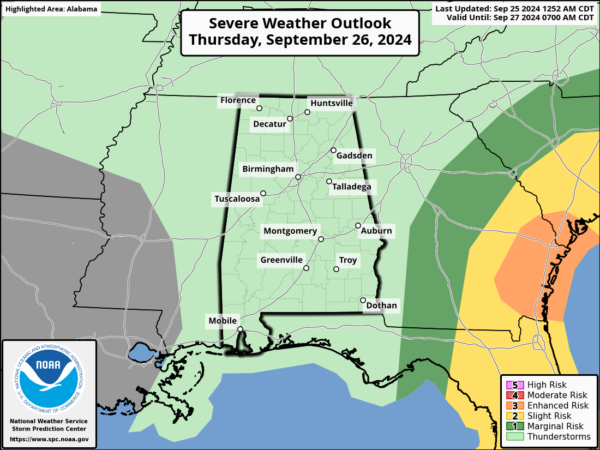
WET WEDNESDAY: The SPC maintains a “marginal risk” (level 1/5) of severe thunderstorms much of East and South Alabama, as the front continues to sink south through the state. Gusty winds and hail are possible, and a very low end threat of a tornado. Today’s rain and storms are not associated with Helene. The rain and storms will shifts south and east later this afternoon and evening.
BIRMINGHAM ALMANAC: For September 25th, the average high for Birmingham is 84° and the average low is 62°. The record high is 98° set in 2016, while the record low is 43° set in 1990. We average 0.12” of precipitation on this date, and the record value is 2.50” set in 1921.
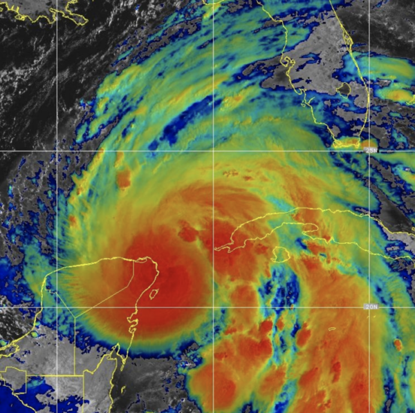
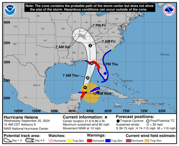
HELENE: Is now a hurricane as of 1000 AM CDT, the center of Hurricane Helene was located near latitude 21.6 North, longitude 86.3 West. Helene is moving toward the north-northwest near 10 mph. A turn toward the north and north-northeast with an increase in forward speed is expected later today through Thursday, bringing the center of Helene across the eastern Gulf of Mexico and to the Florida Big Bend coast by Thursday evening. After landfall, Helene is expected to slow down and turn toward the northwest over the southeastern United States Friday and Saturday.
Data from NOAA and Air Force Reserve Hurricane Hunter aircraft indicate that maximum sustained winds have increased to near 80 mph with higher gusts. Additional strengthening is forecast, and Helene is expected to be a major hurricane when it reaches the Florida Big Bend coast Thursday evening. Weakening is expected after landfall, but Helene’s fast forward speed will allow strong, damaging winds, especially in gusts, to penetrate well inland across the southeastern United States, including over the higher terrain of the southern Appalachians. Hurricane-force winds extend outward up to 25 miles from the center and tropical-storm-force winds extend outward up to 275 miles. The minimum central pressure based on dropsonde is 979 mb (28.91 inches).
Over the next couple of days, Helene will be moving through an environment of low vertical wind shear, ample environmental moisture, and over waters of high oceanic heat content. All guidance forecasts steady to rapid intensification, including the RI indices associated with the SHIPS model. The latest forecast calls for a 125 mph intensity by 36 hours, and this could be conservative as some of the guidance is stronger.
Helene’s wind field is predicted to grow to a very large size in the NHC forecast. Therefore storm surge, wind, and rainfall impacts will likely extend well away from the center and outside the forecast cone, particularly on the east side. In addition, the fast forward speed while Helene crosses the coast will likely result in farther inland penetration of strong winds over parts of the southeastern United States after landfall.
Landfall will come tomorrow evening on the Florida coast south of Tallahassee, and east of Apalachicola; Helene is expected to be a major hurricane (category three) with winds of 125 mph at that time. There has been very little change in the track forecast over the past 48 hours.
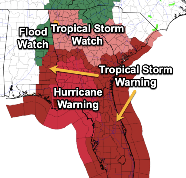
ALABAMA IMPACTS: The farther east in the state you are, the greater the impacts from Helene. First off, there is no threat of tornadoes in Alabama with Helene, since we are west of the center of circulation. We will have to deal with heavy rainfall and gusty winds.
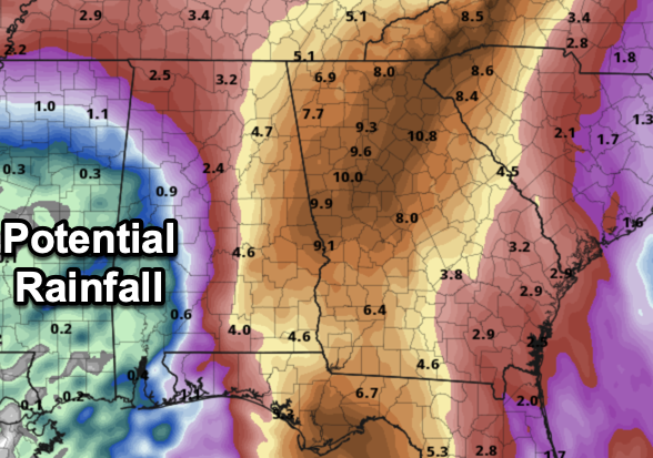
We have a flood watch in effect for pretty much the eastern half of the state, east of Interstate 65. These areas could see rainfall totals of 2-5 inches, which will cause flash flooding, and could cause river flooding. We do expect river flooding to be an issue for the Coosa, Tallapoosa, and Chattahoochee Rivers, as all the rainfall in north Georgia, including the Atlanta Metro will have to flow south through the rivers.
The southeast portion of Alabama from Dothan to Troy to Auburn could see wind gusts to 40/60 mph tomorrow night; a tropical storm warning has been issued and expanded for Houston, Henry, Geneva, Coffee, Dale, Pike, Russell, Macon, Bullock, Lee, Chamber, and Barbour counties. The rest of East Alabama will see gusts to 45 mph; gusts over the western half of the state will be in the 20-25 mph range. Highest wind velocities will be east of Alabama over North Florida and Georgia.
Remember, any tropical forecast can change. Watch for updates!
The weather will improve across Alabama by midday Friday; we expect just a few isolated, light showers Friday night and Saturday. Bottom line is that the weather won’t be bad at all for high school and college games in the state, but just keep mind a passing shower can’t be ruled out. Wind will be under 10 mph.
NEXT WEEK: The weather looks generally dry with highs in the low 80s with lows in the 50s and 60s…Very nice and pleasant weather as we start the month of October.
WORLD TEMPERATURE EXTREMES: Over the last 24 hours, the highest observation outside the U.S. was 114.3F at Omidieh, Iran. The lowest observation was -83.2F at Vostok, Antarctica.
CONTIGUOUS TEMPERATURE EXTREMES: Over the last 24 hours, the highest observation was 112F at Palm Springs and Ocotillo, CA. The lowest observation was 27F at Peter Sinks, UT.
Category: Alabama's Weather, ALL POSTS, Social Media
About the Author (Author Profile)
Macon, Georgia Television Chief Meteorologist, Birmingham native, and long time Contributor on AlabamaWX. Stormchaser. I did not choose Weather, it chose Me. College Football Fanatic. @Ryan_StinnetSubscribe
If you enjoyed this article, subscribe to receive more just like it.


