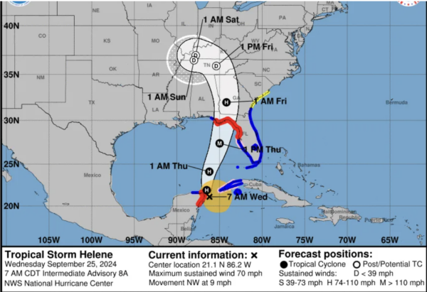
7AM CDT Helene Update: New NHC Intermediate Advisory
The NHC has released its 7AM CDT Intermediate Advisory, and here are the new stats:
SUMMARY OF 700 AM CDT…1200 UTC…INFORMATION
———————————————-
LOCATION…21.1N 86.2W
ABOUT 60 MI…100 KM ENE OF COZUMEL MEXICO
ABOUT 100 MI…160 KM WSW OF THE WESTERN TIP OF CUBA
MAXIMUM SUSTAINED WINDS…70 MPH…110 KM/H
PRESENT MOVEMENT…NW OR 325 DEGREES AT 9 MPH…15 KM/H
MINIMUM CENTRAL PRESSURE…979 MB…28.91 INCHES
CHANGES WITH THIS ADVISORY:
The Tropical Storm Warning has been extended northward to Altamaha
Sound, Georgia.
SUMMARY OF WATCHES AND WARNINGS IN EFFECT:
A Storm Surge Warning is in effect for…
* Indian Pass southward to Flamingo
* Tampa Bay
* Charlotte Harbor
A Hurricane Warning is in effect for…
* Anclote River to Mexico Beach, Florida
* Cabo Catoche to Tulum, Mexico including Cozumel
A Hurricane Watch is in effect for…
* Cuban province of Pinar del Rio
* Englewood to Anclote River, including Tampa Bay
A Tropical Storm Warning is in effect for…
* Dry Tortugas
* All of the Florida Keys
* The Florida west coast from Flamingo to Anclote River, including
Tampa Bay
* West of Mexico Beach to the Walton/Bay County Line
* The Florida east coast from Flamingo northward to Altamaha Sound,
Georgia
* Lake Okeechobee
* Rio Lagartos to Cabo Catoche, Mexico
* Cuban provinces of Artemisa, Pinar del Rio, and the Isle of Youth
A Tropical Storm Watch is in effect for…
* Georgia and South Carolina coast north of Altamaha Sound to the
South Santee River
Helene is currently located very close to the Yucatan Peninsula, and is forecast to continue moving northwards into the Gulf of Mexico. The next couple of hours will be crucial, as interaction with land could act to slow the storm’s strengthening. Right now, models are suggesting that the storm will only clip the Yucatan Peninsula, meaning this very short interaction with land probably won’t have much of an effect.
Maximum sustained winds as of 7AM CDT were 70 mph, which is just short of hurricane force winds. Hurricane development should occur within the next few hours. The minimum pressure continues to drop, with 979mb being recorded by an Air Force aircraft.
Landfall is still predicted to occur late in the evening on Thursday, with the landfall site being Florida’s Big Bend region. As a reminder, tropical storm force winds could be felt up to 175 miles away from the center of the storm.
Storm surge and flooding will be a massive concern for the Florida coast once the storm approaches. Here are the current estimations from the NHC (note these numbers reflect peak surge levels if it occurs at high tide):
Ochlockonee River, FL to Chassahowitzka, FL…10-15 ft
Chassahowitzka, FL to Anclote River, FL…6-10 ft
Indian Pass, FL to Ochlockonee River, FL…5-10 ft
Anclote River, FL to Middle of Longboat Key, FL…5-8 ft
Tampa Bay…5-8 ft
Middle of Longboat Key, FL to Englewood, FL…4-7 ft
Englewood, FL to Flamingo, FL…3-5 ft
Charlotte Harbor…3-5 ft
We will continue to update as new information comes in throughout the day today. The next full advisory from the NHC will be at 10AM CDT, and we will have a full breakdown of that.
The forecast will continue to be refined, especially through tonight, as the storm continues to strengthen and approaches landfall. Remember that forecasts can change, so it is important to stay up to date on current information.
Category: ALL POSTS, Social Media, Tropical


