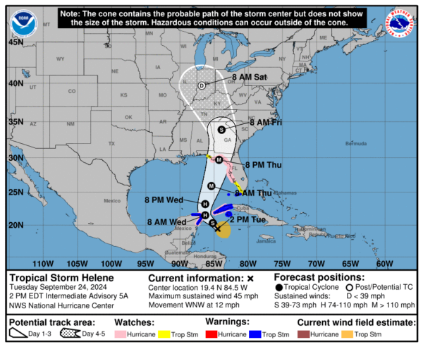
1pm CDT Helene Update and a Look at the Latest Model Trends
Helene is trying to get its act together over the NW Caribbean. Latest advisory shows the pressure is down another millibar. It is moving now more WNW.
Stats:
LOCATION…19.4N 84.5W
ABOUT 175 MI…280 KM ESE OF COZUMEL MEXICO
ABOUT 175 MI…280 KM S OF THE WESTERN TIP OF CUBA
MAXIMUM SUSTAINED WINDS…45 MPH…75 KM/H
PRESENT MOVEMENT…WNW OR 295 DEGREES AT 12 MPH…19 KM/H
MINIMUM CENTRAL PRESSURE…999 MB…29.50 INCHES
Advisory changes:
The government of the Cayman Islands has discontinued the Tropical Storm Warning for Grand Cayman.
The NHC states that Helene has been wobbling a bit but the general motion is WNW. A turn to the NW will resume later today and then a north to northeast motion and a quicker pace will occur Wed and Thu. Hurricane status is still expected tomorrow and possibly a major hurricane approaching landfall. Tropical-storm-force winds extend outward up to 140 miles to the east of the center.
Some of the 12Z model runs are coming in and some are showing perhaps a weaker trend as Helene approach the US. It may encounter some wind shear. Also, as Andy Hazelton points out, some of the models show Helene clipping the Yucatan peninsula. What impact could that make to the structure of the storm?
Last updated model to arrive for 12z is the ECMWF HRES, and it shows a rather disheveled Helene at 975 mb — Category 2+ — based upon the very large size.
However, wind shear from an upper-level trough to the WNW may (hopefully) keep from maximum potential. pic.twitter.com/8Wy8NGQUG6
— Ryan Maue (@RyanMaue) September 24, 2024
The 12Z HAFS-A/HAFS-B runs (with TDR assimilated) are slightly weaker initially, and one big change is they both show #Helene moving into the tip of the Yucatan for a period tomorrow. If so, that would delay the development of a core and probably lead to a weaker peak intensity… https://t.co/g6lvNNgWi2 pic.twitter.com/7FJUiXQV0o
— Andy Hazelton (@AndyHazelton) September 24, 2024
It will be interesting to watch the real-time data come in along with the model trends. The messaging is still the same: A growing hurricane will be heading through eastern Gulf and will have widespread impacts. From storm surge, to flooding rains, and very strong winds. And this will impact a huge area of the southeast. We will continue to watch and have update throughout the event!
Category: ALL POSTS, Social Media, Tropical


