7am Tropics Update: Hurricane Hunters Are Investigating; Disturbance Still Battling Shear
Quick update with this intermediate advisory from the NHC. First the stats for those tracking along with me:
LOCATION…19.2N 83.5W
ABOUT 150 MI…240 KM W OF GRAND CAYMAN
ABOUT 205 MI…335 KM SSE OF THE WESTERN TIP OF CUBA
MAXIMUM SUSTAINED WINDS…35 MPH…55 KM/H
PRESENT MOVEMENT…NW OR 305 DEGREES AT 9 MPH…15 KM/H
MINIMUM CENTRAL PRESSURE…1001 MB…29.56 INCHES
No major changes here and no updates to advisories right now.
I am constantly reviewing updates from tropical meteorologists and saw this update from Alex Boreham.
#PTC9 remains sheared this morning with a SW/NE elongated LLC on SWIR and suggested from recon. This TDR pass certainly does not suggest well defined low. Despite this disorganization, pressures are very gradually dropping. We can also see some of the northern convection push… pic.twitter.com/x3F5DcC030
— Alex Boreham (@cyclonicwx) September 24, 2024
The disturbance is still battling shear and does not have a defined center. He denotes pressures are very slowly falling though. It continues to be a waiting game in real-time. When the shear eases (which the models show), then conditions will be more favorable for development.
Andy Hazelton is another great follow. He is an Associate Scientist at UM/CIMAS and NOAA AOML/HRD. He also denotes the shear but also thinks we could have a tropical storm soon.
The Hurricane Hunters are flying into this system as I type this. Still not denoting strengthening yet.
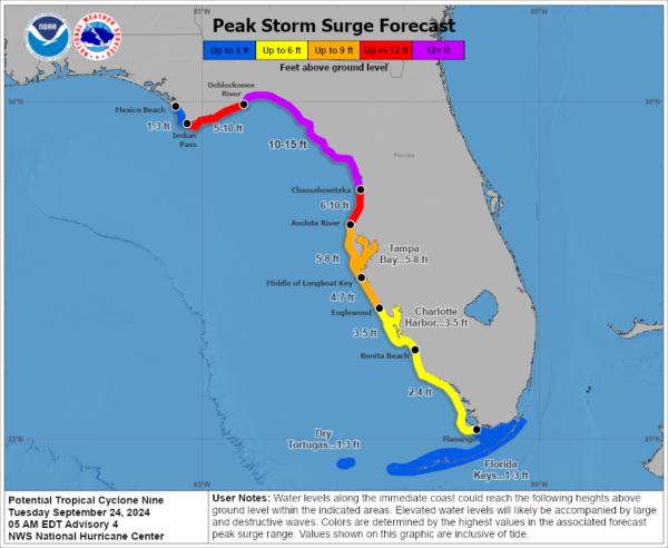
I want to focus this update on the surge forecast. We are expecting to see Helene grow into a strong hurricane once it breaks out of the shear and heads more into the eastern Gulf. Most models predict this and we have to be prepared for that. For those near and east of the center, dangerous surge is possible. The latest peak surge forecast shows the possibility of 10-15 feet of inundation from the Ochlockonee River to Chassahowitza. 5-8 feet storm surge possible for Tampa Bay. 3-5 Feet as far south as Charlotte Harbor. This is expected to become a large, quick-strengthening system with widespread impacts away from the center with that water being pushed into the Florida Gulf Coast. Please prepare for that.
Category: ALL POSTS, Social Media, Tropical


