7pm CDT Tropics Update: Major Hurricane Expected Later this Week
Information from the NHC 7pm CDT Intermediate Advisory
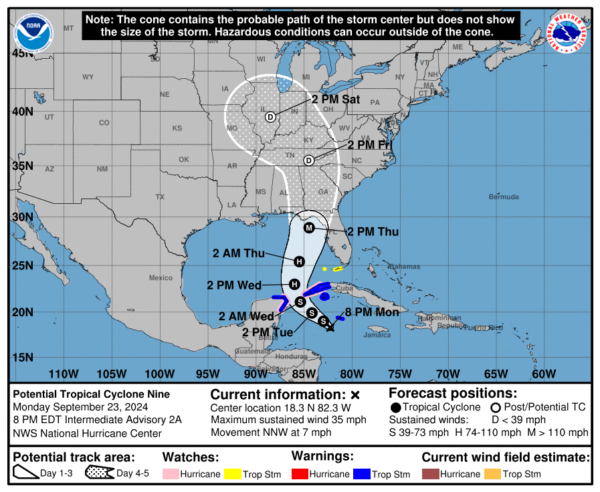
7pm CDT Stats:
LOCATION…18.3N 82.3W
ABOUT 100 MI…160 KM SW OF GRAND CAYMAN
ABOUT 300 MI…485 KM SE OF THE WESTERN TIP OF CUBA
MAXIMUM SUSTAINED WINDS…35 MPH…55 KM/H
PRESENT MOVEMENT…NNW OR 345 DEGREES AT 7 MPH…11 KM/H
MINIMUM CENTRAL PRESSURE…1002 MB…29.59 INCHES
Changes with this Advisory:
A tropical storm warning has been issued for Grand Cayman.
Other Current Advisories Include:
A Hurricane Watch is in effect for…
* Cabo Catoche to Tulum, Mexico
* Cuban province of Pinar del Rio
A Tropical Storm Warning is in effect for…
* Grand Cayman
* Rio Lagartos to Tulum, Mexico
* Cuban provinces of Artemisa, and Pinar del Rio, and the Isle of
Youth
A Tropical Storm Watch is in effect for…
* Dry Tortugas
* Lower Keys south of the Seven Mile Bridge
The NHC is now suggesting the possibility of tropical storm/hurricane watches being added for the Florida Coastline as soon as tonight or tomorrow.
Right now, maximum winds within the system are around 35 mph and the pressure level in the center is estimated to be 1002mb. The NHC is expecting hurricane development by Wednesday. Intense and rapid strengthening of the storm is expected overnight Wednesday into Thursday. High storm surge and hurricane force winds will be a major hazard with this storm, especially to the east of the forecasted area of landfall.
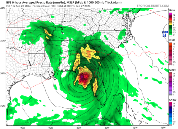
As we continue to get new model data, the forecast for expected hurricane Helene will slightly change over the next couple of days. The latest run of the GFS model at 18Z shows the storm making landfall a few hours earlier than previous runs showed, putting landfall around the evening hours of Thursday, September 26. The expected track of the storm has slightly changed throughout the day today, but the general area of predicted landfall remains the same.
Right now, models are suggesting that landfall will occur somewhere between St. George Island, FL and Tampa, FL. As we go through this week, we should start to be able to narrow down the predicted landfall location to an even smaller area. Estimated windspeeds at landfall are around 115 mph, meaning the storm would reach Category 3 status. Right now, the storm is still in the process of formation, so model data still needs to be taken lightly.
As we have been mentioning, it is imperative that residents along the Florida coastline create a hurricane plan ASAP, if they have not already done so. If the storm strengthens in the way it is forecast to, which is very likely, there is the possibility of mandatory evacuations being implemented along the Florida Coastline. Please urge anyone you know in the path of this dangerous storm to begin developing a plan, so they are prepared for what is to come later this week.
We will continue to update you as new information comes in.
Category: ALL POSTS, Social Media, Tropical


