4pm CDT Tropics Update: First Advisories for Parts of the US Issued; Major Hurricane Status Expected on Thursday
We have the thorough 4pm CDT update from the NHC and there have been some changes. Let’s get to it:
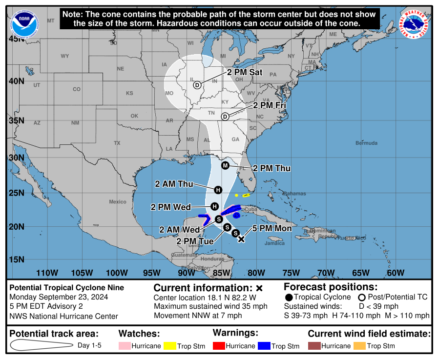
Stats:
LOCATION…18.1N 82.2W
ABOUT 105 MI…170 KM SW OF GRAND CAYMAN
ABOUT 315 MI…510 KM SE OF THE WESTERN TIP OF CUBA
MAXIMUM SUSTAINED WINDS…35 MPH…55 KM/H
PRESENT MOVEMENT…NNW OR 345 DEGREES AT 7 MPH…11 KM/H
MINIMUM CENTRAL PRESSURE…1003 MB…29.62 INCHES
New Advisories:
A Tropical Storm Watch has been issued for the Dry Tortugas and the Lower Florida Keys south of the Seven Mile Bridge.
We can’t stress enough to start preparing now. If you have friends and family in the Florida Panhandle down to the west coast of Florida, please give them a call and make sure they are ready. The forecast is calling for a major hurricane by Thursday afternoon off the Big Bend coast. Impacts though will be widespread. The risk of life-threatening storm surge is increasing for the Florida Panhandle through the west coast of Florida. The NHC states that storm surge watches could be placed by tonight or very early Tuesday morning. You must have your hurricane plan in place.
The latest forecast track is not much different from the previous one. A turn to the NW is expected over the next 24 hours. It will pass between the Yucatan Peninsula and Cuba. Soon to be Helene will then move north to northeast at a quicker pace deepening tremendously as it approaches the NE Gulf Coast and FL Panhandle.
The NHC notes that the statistical rapid intensification guidance (SHIPS and DTOPS) shows a 65-kt increase in in 72 hours. The NHC shows a major hurricane on Thursday. They also note: “This intensity forecast still lies below the consensus aids, with the regional hurricane models and the GFS showing even more deepening.”
The NHC winds at 72 hours is 115 mph at the center. That is Category 3. There is a chance the hurricane could even be stronger.
The 18Z model runs are just now starting to come in and some of them have shifted a bit to the east. We have to watch these jogs as that would have a huge impact on who see the worst surge. This is the ICON model. This is a German model. Just one model run but we need to pay attention to this from the other runs that start to come in from other models. This is as of 21Z on Thursday. (late afternoon)
![]()
Category: ALL POSTS, Social Media, Tropical
About the Author (Author Profile)
Owner of Tornado Talk. Radio broadcast meteorologist with The Storm Report. WeatherBrains Panelist. B.S. Meteorology from Penn State University.Subscribe
If you enjoyed this article, subscribe to receive more just like it.


