
Hurricane Landfall Expected Thursday Evening On The Florida Coast
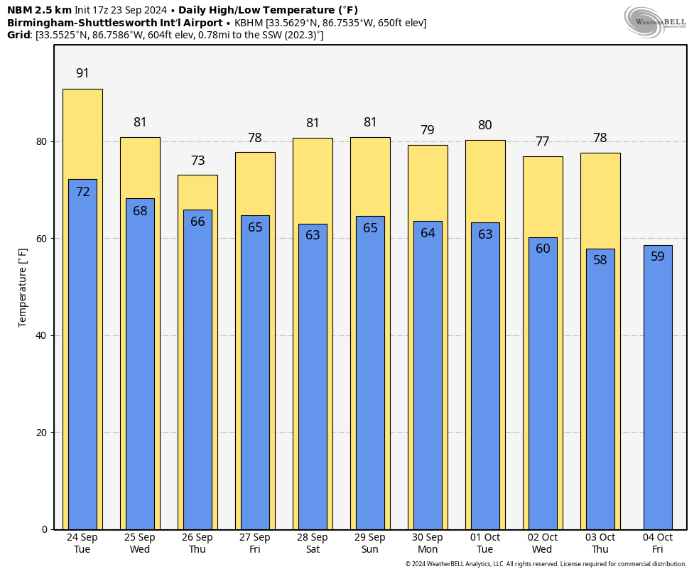
HOT SEPTEMBER AFTERNOON: Temperatures are generally in the 89-94 degree range across Alabama this afternoon; there are few small isolated showers over the Tennessee Valley, but most of the state is dry. Tonight will be generally fair with a low between 68 and 74 degrees.
While much of the state will be dry tomorrow, a few strong storms could form over the Tennessee Valley during the afternoon and evening hours, where SPC has a “marginal risk” (level 1/5) defined. The main threats are small hail and strong, gusty winds. The high will be in the low 90s, but this should be the last day above 90 for quite a while.
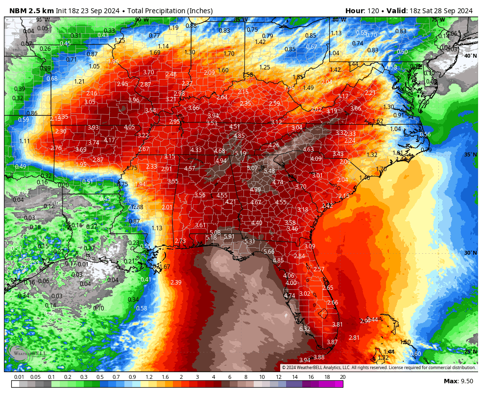
The weather turns wet on Wednesday thanks to increasing moisture from the south, and a surface front approaching from the northwest. Occasional rain continues Thursday, possibly becoming heavy Thursday night as the tropical system passes just to the east over Georgia. Showers remain possible Friday and Friday night, but it won’t rain all day. The amount of rain we see here Wednesday through Friday all depends on the tropical system moving in from the Gulf.
PTC 9: NHC has initiated advisories on “Potential Tropical Cyclone Nine”. The name of the system will be Helene. PTC 9 is about 340 miles southeast of the western tip of Cuba, with winds of 30 mph.
KEY MESSAGES
*The new 12z model set has shifted a bit to the east. Higher landfall probabilities are from Apalachicola to Cedar Key.
*The current NHC forecast is for Helene to be a category two hurricane with winds of 110 mph at the time of landfall Thursday afternoon/evening, but some ensemble members show the system coming in as a major hurricane (category three or higher).
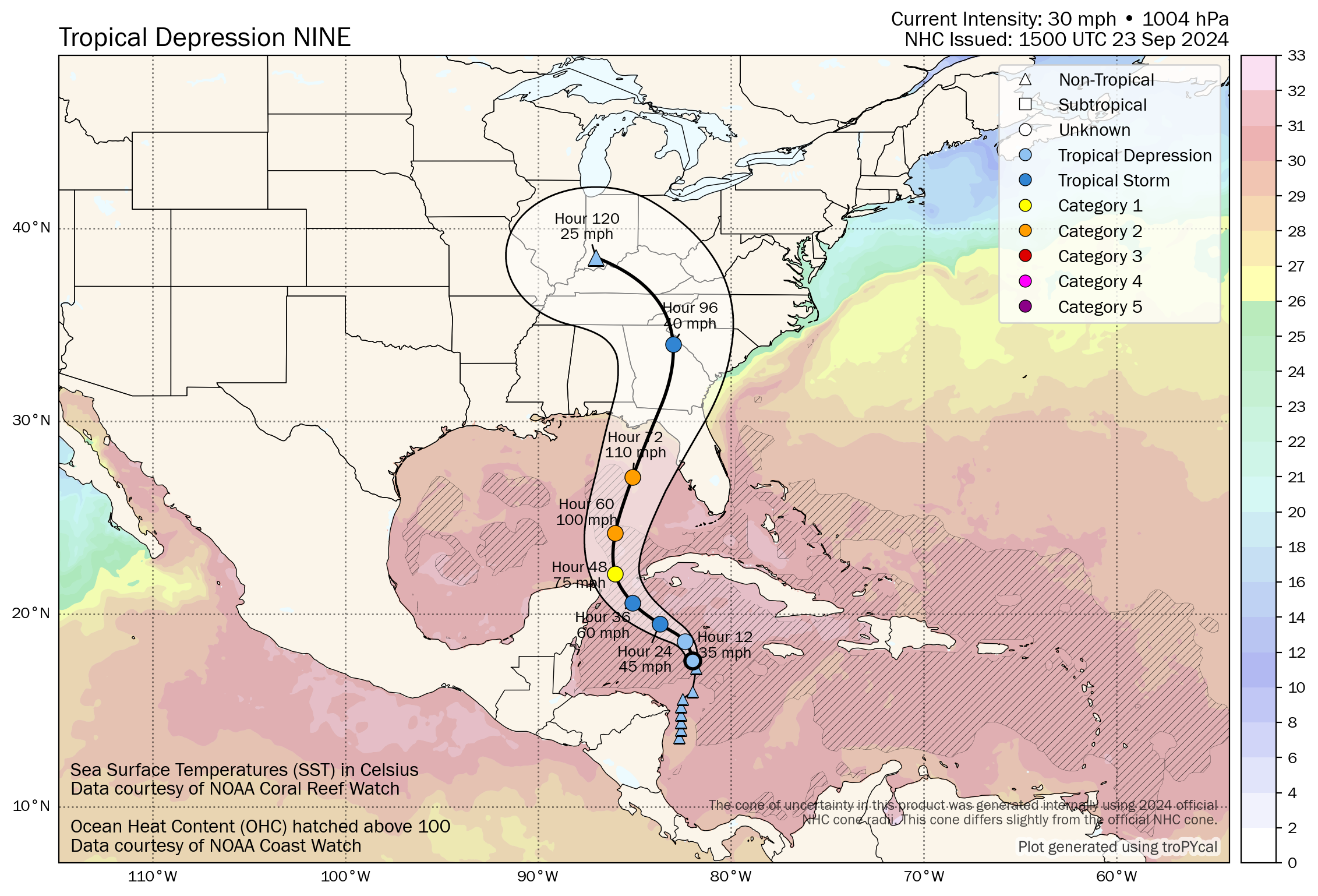
*The Alabama Gulf Coast, and the western Florida Panhandle (Pensacola to Panama City Beach) are on the good, west side of the circulation for now with an offshore flow.
*The main impact in terms of storm surge, wind, freshwater flooding, and isolated tornadoes will be along and to the east of the track center line. This includes the West Coast of Florida (places like Tampa and St. Petersburg).
*Remember, a hurricane is not a dot on a map… impacts can extend far from the center, especially on the east side.
*The amount of rain in Alabama Wednesday through Friday is currently expected to be in the 2-5 inch range for the northern and eastern counties, with lighter amounts for West and South Alabama.
*Highest wind velocities will likely be east of Alabama Thursday and Thursday night across Georgia, but gusts could be in the 35-45 mph range across Southeast Alabama.
*For the college football games Saturday in Alabama, we expect nothing more than isolated showers. No high wind issues.
Please remember this forecast can easily change. Once we have a low level center and data from hurricane hunters, model data will be more reliable. Stay tuned for updates!
ON THIS DATE IN 1975: Hurricane Eloise made landfall as a major hurricane east of Fort Walton Beach and Destin around 7a CT on September 23, 1975. Eloise was the first major hurricane to strike the region in 4 decades.
According to the NOAA Assessment, Herbert Saffir estimated winds in excess of 120 mph based on the structural wind damage he observed in Eloise. Shortly after Eloise made landfall, a peak wind gust of 115 mph was recorded at Eglin AFB (before the instrument failed) with 85 mph gusts at Hurlburt Field. Eloise weakened as it pushed inland across Alabama through the day.
Look for the next video briefing here by 6:00 a.m. tomorrow…
Category: Alabama's Weather, ALL POSTS, Weather Xtreme Videos
About the Author (Author Profile)
James Spann is one of the most recognized and trusted television meteorologists in the industry. He holds the AMS CCM designation and television seals from the AMS and NWA. He is a past winner of the Broadcast Meteorologist of the Year from both professional organizations.Subscribe
If you enjoyed this article, subscribe to receive more just like it.


