Northern Gulf Coast Will Have to Be Vigilant As 97L/Future Helene Plots it Course
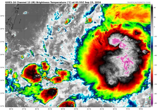
Intense convection continues tonight over the northwestern Caribbean Sea in association with Invest 97L. It is fairly concentrated and circular. And there appears to be well established outflow.
A microwave satellite pass showed an apparent center near 15N -82W. This is on the western side of the deep convection, so the system is still not very organized. I would not be surprised to see the center reform a little further to the east. That would be more in line with the GFS depiction of how things will develop tomorrow.
The 18z run of the GFS from this afternoon does have a depression forming in that area by tomorrow morning. ‘
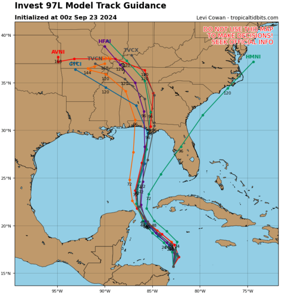
The early track guidance from 0z is clustered on the Mexico Beach, Apalachicola area.
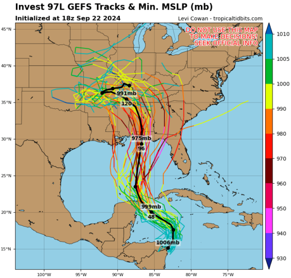
But the GFS ensembles from 18z are more concerning for points further west, including the central Panhandle into South Alabama.
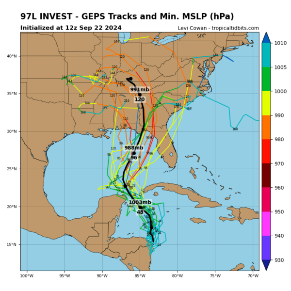
The European ensembles seems to be playing catch up to the GFS.
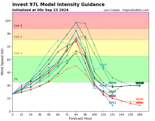
The intensity guidance is concerning as well:
The water is extremely warm with high oceanic heat content all along the track. In fact, the storm will pass over the Loop Current over the southern Gulf, which will be like jet fuel with its high oceanic heat content. Divergence aloft looks favorable along the track, as does atmospheric moisture. In fact, the one fly in the ointment against strengtehing is outflow from Depression Ten in the eastern Pacific, but there are signs that won’t be a problem.
We are starting to see some of the hurricane mesoscale models. The HMON looks like a 90 knot hurricane hitting Cedar Key around 7 p.m. CDT Thursday. The HWRF is way too fast bringing it into the Big Bend Thursday morning as a 90 knot hurricane. The HAFS-A predicts landfall Thursday afternoon in the 30A area at around 90 knots. The HAFS-B is a little slow and a little weaker with landfall around Panama City Thursday afternoon.
As you can see there is still a great deal of uncertainty. This large spread in tracks means we can pin down impacts for any specific areas, but all interests along the northern and northeastern Gulf Coast have to be vigilant.
Five Hurricane Hunter flights are tasked into the storm tomorrow…we will start to know a lot more then…the first one is due on station at 1 p.m. CDT:
REPRPD
WEATHER RECONNAISSANCE FLIGHTS
CARCAH, NATIONAL HURRICANE CENTER, MIAMI, FL.
1255 PM EDT SUN 22 SEPTEMBER 2024
SUBJECT: TROPICAL CYCLONE PLAN OF THE DAY (TCPOD)
VALID 23/1100Z TO 24/1100Z SEPTEMBER 2024
TCPOD NUMBER…..24-114 CORRECTION
I. ATLANTIC REQUIREMENTS
1. SUSPECT AREA (NORTHWESTERN CARIBBEAN SEA)
FLIGHT ONE – TEAL 71 FLIGHT TWO – TEAL 72
A. 23/1800Z A. 24/0530Z
B. AFXXX 01HHA INVEST B. AFXXX 0209A CYCLONE
C. 23/1430Z C. 24/0230Z
D. 17.5N 83.5W D. 18.0N 84.0W
E. 23/1730Z TO 23/2230Z E. 24/0500Z TO24/0830Z
F. SFC TO 10,000 FT F. SFC TO 10,000 FT
G. LOW-LEVEL INVEST G. FIX
H. WRA ACTIVATION H. WRA ACTIVATION
FLIGHT THREE – NOAA 49 FLIGHT FOUR – NOAA 43
A. 24/1200Z A. 24/1200Z
B. NOAA9 0309A CYCLONE B. NOAA3 0409A CYCLONE
C. 24/0530Z C. 24/0800Z
D. NA D. 18.5N 84.5W
E. NA E. 24/1000Z TO 24/1400Z
F. 41,000 TO 45,000 FT F. SFC TO 15,000 FT
G. SYNOPTIC SURVEILLANCE G. TAIL DOPPLER RADAR
H. NO WRA ACTIVATION H. WRA ACTIVATION
FLIGHT FIVE – TEAL 73
A. 24/1130,1730Z
B. AFXXX 0509A CYCLONE
C. 24/0830Z
D. 18.5N 84.5W
E. 24/1100Z TO 24/1730Z
F. SFC TO 15,000 FT
G. FIX
H. WRA ACTIVATION
2. SUCCEEDING DAY OUTLOOK:
A. CONTINUE 6-HRLY FIXES IF SYSTEM DEVELOPS.
B. TWO MORE NOAA P-3 TAIL DOPPLER RADAR MISSIONS INTO
THE SUSPECT AREA FOR 25/0000Z AND 25/1200Z, DEPARTING KLAL
AT 24/2000Z AND 25/0800Z RESPECTIVELY.
C. TWO MORE NOAA G-IV SYNOPTIC SURVEILLANCE MISSIONS AROUND
SUSPECT AREA FOR 25/0000Z AND 25/1200Z, DEPARTING KLAL
AT 24/1730Z AND 25/0530Z RESPECTIVELY.
Category: Alabama's Weather, ALL POSTS, Social Media, Tropical

