
What is Going on in the Gulf of Mexico?
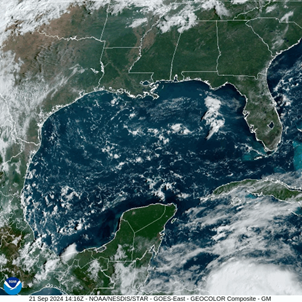
Right now, the Gulf of Mexico looks pretty quiet on satellite. A few clouds are present here and there, but nothing major is occurring. However, behind the scenes, the atmosphere above and the ocean below are both becoming ripe environments for any system that sets up in this area. Next week, this exact thing will take place. A system of disorganized storms will move into the Gulf region, and will have a good chance of developing into a more organized tropical system.
Over the next week, the air above the Gulf of Mexico is set to stay very wet, which is a great factor for tropical storm development. This is in contrast to what occurred with Francine, which struggled to maintain itself after marching into an area with quite dry conditions. Right now, sea surface temperatures are around 86 degrees, which is far higher than the 80 degrees mark we look for when evaluating whether a storm can strengthen or not.
Next week, though, the GFS model is showing an increase in wind shear in the Gulf. This can challenge a tropical system, as wind shear can knock a storm off-balance, so to speak. This could hurt any potential development as it gets closer to landfall.
As for the track of any developed storm, things are still a little unclear. Models can have a hard time analyzing a tropical storm’s path before it has formed, and that is exactly the case here. There are a wide variety of predictions, so I have included the “best-case” and the “worst-case” scenario for the Alabama Coast.
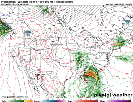
The latest run of the GFS model shows the storm making landfall on the coast of the Florida Panhandle, just missing the Alabama coastline. Out of all the current model runs, this appears to be the one showing the least amount of impacts for Coastal Alabama cities. Most of the flooding and high winds potential would be to the east in Florida.
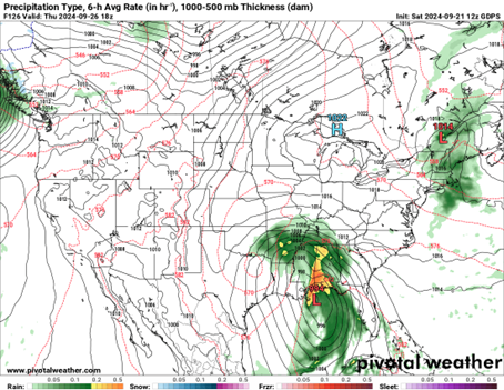
The GDPS model is telling a slightly different story than the GFS. It has the storm making landfall more to the west, on the Mississippi Coast. If this is the case, this would bring the flooding concern to the Alabama coast. High winds would also be a potential threat to the area. If this does occur, the middle and eastern side of Alabama could see some potential for severe storms as the system moves inland.
As is often the case when looking at tropical systems, the models are changing with each run. We are still pretty far out from the predicted landfall, so there will likely be many changes to this forecast. Stay tuned for updates as we head into next week!
Category: ALL POSTS, Social Media, Tropical
About the Author (Author Profile)
Scott is a senior at Mississippi State University studying professional and broadcast meteorology.Subscribe
If you enjoyed this article, subscribe to receive more just like it.


