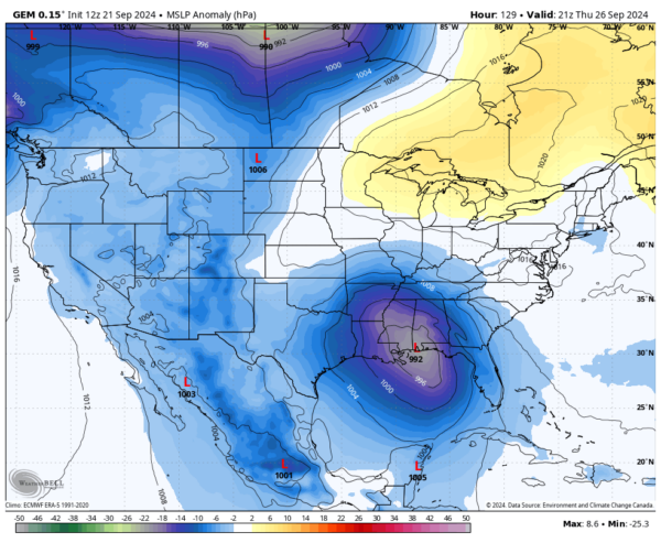
Models Are Starting to Become A Little Closer in Agreement on the Tropical Weather Threat for the Gulf of Mexico
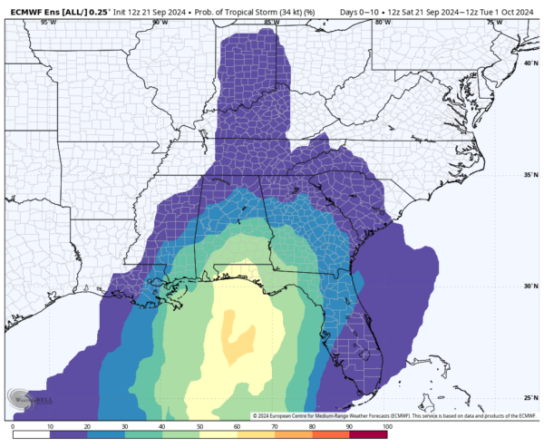
The latest European ensemble members model run is out, and there is a 60% chance that a tropical storm will develop over the Gulf of Mexico. The main questions are… Where will it go? How strong? Will it affect Central Alabama? Well, I can’t give you completely correct answers as we are still waiting for the system to actually form a central low pressure and move into a more conducive atmosphere. Hopefully, all of these model images will show you, in some form or fashion, a general direction of the system. This is why tropical systems are so hard to predict their directions and/or their strengths. They currently do not have a location to start their projections from, and not knowing that, models will not be able to show a near-perfect forecast, unless it was a lucky guess. Here’s what I got.
Here is the latest from the National Hurricane Center’s Tropical Weather Outlook for this potential tropical mischief…
Northwestern Caribbean Sea and Gulf of Mexico:
A broad area of low pressure is likely to form by the early to middle part of next week over the northwestern Caribbean Sea and the adjacent portions of Central America. Thereafter, gradual development of this system is possible, and a tropical depression could form as the system moves slowly northward across the northwestern Caribbean Sea and Gulf of Mexico through the end of next week. Regardless of development, this system is expected to produce heavy rains over portions of Central America during the next several days.
* Formation chance through 48 hours…low…near 0 percent.
* Formation chance through 7 days…medium…60 percent.
So, at this point, the NHC has not seen any reason to change their outlook from this morning’s post. But let me tell you something, the models have shown some big changes, which may have the Alabama and Florida Panhandle beaches go on guard and prepare for some rough weather potentially heading their way. Here are what the models are showing us this afternoon…
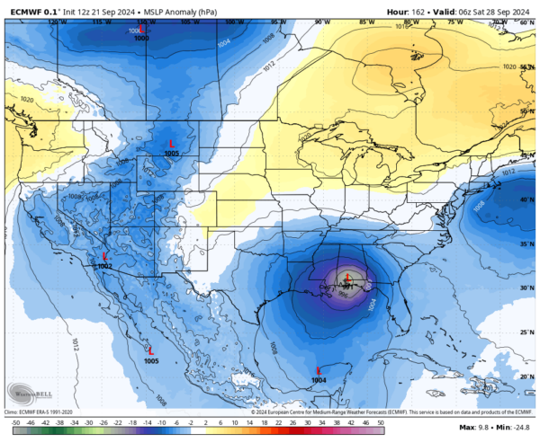
This is one that would have the Alabama beaches worries as the European model has the center of a weak category 1 hurricane moving onshore right around the Alabama/Florida state line, potentially over Pensacola, right around the predawn hours on Saturday 9/28. The center will track through the western parts of Alabama before hanging a left and moving into northeast Mississippi by midnight. Severe weather will be possible for the eastern 2/3rds of the state, along with gusty to strong winds and torrential tropical rain. The weather will gradually improve on Sunday 9/29.
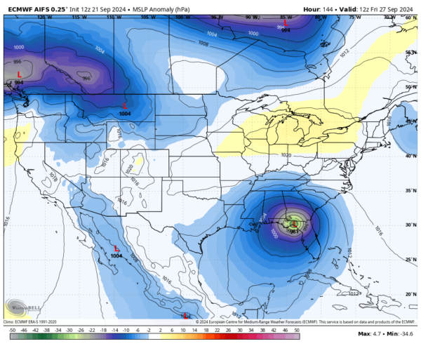
The latest European model run with AI shows a different story, as a category 1 hurricane is progged to make landfall at daybreak on Saturday 9/28 along the Big Bend region of Florida, before making a big direction change to the northwest and the center will move through the northeast corner of Alabama. Much of the state will be on the drier and less active side of the system; however, rain and gusty winds will remain possible throughout the day on Saturday. The good news is that severe weather would not be likely as we’ll be west of the center.
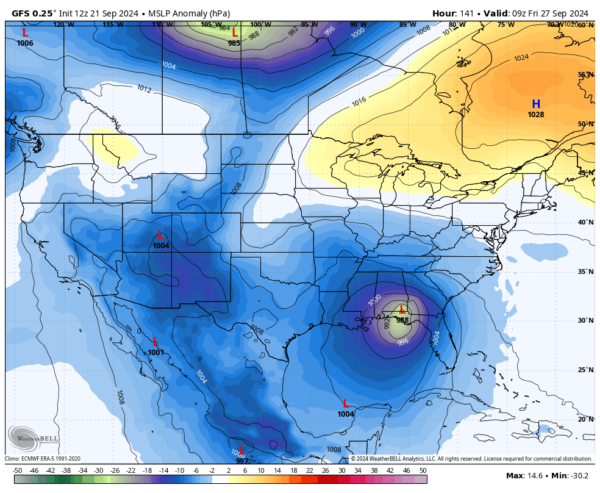
The latest GFS model run now shows the system making landfall a little west than this morning’s run, but still has it moving over the Florida Panhandle with the center making landfall around Panama City Beach during the predawn hours on Friday 9/27. The center would move across the southeastern corner of Alabama with the highest winds affecting locations between Troy and Dothan. Rain and gusty winds will be likely throughout the rest of the state, but no severe weather would be likely, and the rainfall will not be as heavy.
The worst case scenario would be if the Canadian model turned out true, as it has the center of a category 1 hurricane coming straight up Mobile Bay, and landfall occurring right around Mobile as early as late Thursday afternoon 9/26. For the rest of Thursday and into the early part of Friday, gusty to strong winds will be possible for all of Alabama from south to north, with much of the area under the threat of severe weather. There would be heavy rainfall, flooding along the Gulf Coast of Alabama and Mobile Bay, including the dangers of storm surge flooding. Power outages would be likely for some locations with a weaker infrastructure, and some storm damage would also be possible from high winds and a few tornadoes.
And last, but not least, is the Icon model run, which is a new one for me to use, but is very helpful in forecasts. This latest run has the center of either a strong tropical storm, or a weak category 1 hurricane, making landfall on the Louisiana coast just south of Houma, LA, during the predawn hours on Saturday 9/28. It will take a northeasterly turn and move into the southwest portions of Alabama, bringing plenty of rain and wind to the area, before changing directions again and moving north through western Alabama through the rest of the day. That would also mean that we’ll have the threat of severe weather and power outages mainly over the eastern 2/3rds of the state.
Here are NWS Birmingham’s latest thoughts on Central Alabama’s weather for the second half of the work week ahead…
Not many changes needed in the extended this afternoon, as upper level ridging remains over the area through at least Monday. Low rain chances return to the northwest Tuesday afternoon, but expect much of the area to remain dry until Wednesday. There is still much uncertainty for the remainder of the week and into the weekend. For now, will maintain much of the forecast until there is better consistency regarding both a potential disturbance in the Gulf and a closed low/trough in the southern Plains.
Of course, we are still way too far out to even make a forecast as this system hasn’t formed yet. Once the system becomes organized enough to develop a main central low pressure, then the models can give much better projections than what we are seeing at this point. The main thing for us to do is to stay informed and get prepared well before the system develops. If it doesn’t come this way, then you would be prepared for the next. If it does come this way, you’ll be prepared.
Category: Alabama's Weather, ALL POSTS, Severe Weather, Social Media, Tropical


