
Model Madness As We Wait for Tropical Development Over the Gulf of Mexico
As we continue to hear about the potential for a tropical system developing over the Gulf of Mexico next week, the models are all over the place in strength, directions, and landfall locations. Before we get into that, let’s see what the National Hurricane Center has to say on it’s latest forecast update. Since there is no activity in the defined region where development may occur, an Invest designation has not been given yet.
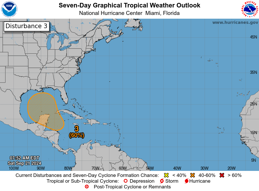
Northwestern Caribbean Sea and Gulf of Mexico:
A broad area of low pressure is likely to form by the early to middle part of next week over the northwestern Caribbean Sea and the adjacent portions of Central America. Thereafter, gradual development of this system is possible, and a tropical depression could form as the system moves slowly to the north or northwest over the northwestern Caribbean Sea and across the Gulf of Mexico through the end of next week. Regardless of development,
this system is expected to produce heavy rains over portions of Central America during the next several days.
* Formation chance through 48 hours…low…near 0 percent.
* Formation chance through 7 days…medium…60 percent.
Now, I did say that the models are all over the board, and I am about to show you what I am talking about. The main reason for this problem is that the system hasn’t even come together, and that causes location problems for the models to start their runs. Here are what the models are saying.
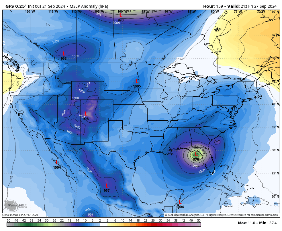
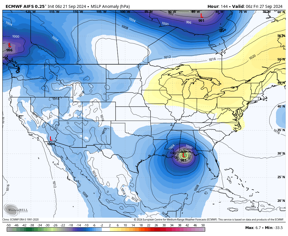
06z GFS run valid on Friday, Sept. 27th at 4pm.
The GFS has a tropical storm developing and moving northward and eventually being caught up in a surface front and will be dragged northeastward and potentially making landfall as a category 2 hurricane somewhere in the Big Bend area of Florida on Friday morning, Sept. 27th. Alabama would be on the dry side of the system, and we may see some clouds and a little breeze.
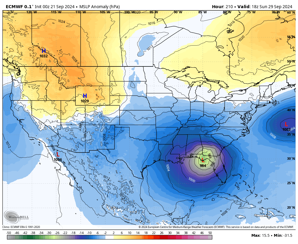
00z European model run valid on Sunday, Sept. 29th at 1pm.
The European model has a tropical storm developing and taking a more north/northeastward path toward the Gulf Coast of the Florida Panhandle, with a potential landfall as a category 1 hurricane around Tallahassee, FL, on Sunday, Sept. 29th during the afternoon. That means there will be a good bit of moisture making up into Alabama and rain would become likely as early as the evening before landfall and spreading northward, along with an increasing breeze. Severe weather would be contained east of Alabama; however, strong winds may be possible around Dothan and other southeastern locations.
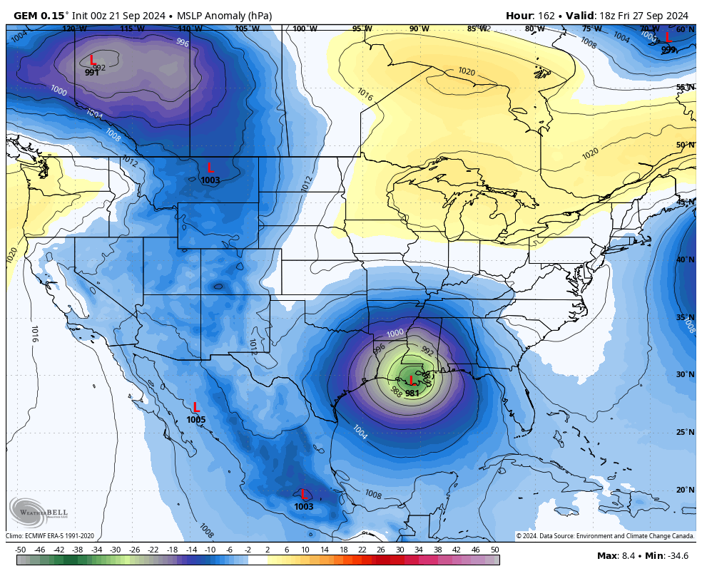
00z Canadian model run valid Friday, Sept. 27th at 1pm.
The Canadian model has the system developing and moving almost due north and moving toward the mouth of the Mississippi River, and potentially making landfall as a category 1 hurricane on Friday afternoon, Sept. 27th, just south of Houma, LA. Conditions would begin to deteriorate at the Alabama Gulf Coast as early as late Thursday afternoon and continue to worsen through the night. The strongest winds will occur Friday afternoon and evening as the center makes landfall not that far west of the Alabama Gulf Coast. Rain and wind will eventually spread into and over much of the rest of the state, and we would have to watch for the threat of severe weather as we’ll be on the more active side. Flooding will be possible over the Gulf Coast of Alabama with storm surge and heavy rain, if this model run is true.
06z European model with AI run valid at 1am, Friday, Sept. 27th.
And probably the worst-case scenario for the beaches of Alabama would be what the European model with AI is showing in its latest run. Once again, this model pretty much has the system moving due north after development, strengthening to a category 1 hurricane, and making a landfall right around the Alabama/Florida state line on very early Friday morning, Sept. 27th. Tropical storm to hurricane force winds would be likely all across the Alabama Gulf Coast and stretching eastward across much of the Florida panhandle to around Tallahassee, and stretching westward to around Intercoastal City. Strong winds and torrential rain would spread northward in South and Central Alabama through the pre-dawn hours, and reaching North Alabama after daybreak. Severe weather would be a great possibility as the center of the low would be moving northward through western Alabama.
Of course, we are still way too far out to even make a forecast as this system hasn’t formed yet. Once the system becomes organized enough to develop a main central low pressure, then the models can give much better projections than what we are seeing at this point. The main thing for us to do is to stay informed and get prepared well before the system develops. If it doesn’t come this way, then you would be prepared for the next. If it does come this way, you are prepared.
I’ll have another update this afternoon. Have a great day!
Category: Alabama's Weather, ALL POSTS, Severe Weather, Social Media, Tropical
About the Author (Author Profile)
Scott Martin is an operational meteorologist, professional graphic artist, musician, husband, and father. Not only is Scott a member of the National Weather Association, but he is also the Central Alabama Chapter of the NWA president. Scott is also the co-founder of Racecast Weather, which provides forecasts for many racing series across the USA. He also supplies forecasts for the BassMaster Elite Series events including the BassMaster Classic.Subscribe
If you enjoyed this article, subscribe to receive more just like it.


