Midday Nowcast: Sunny and Hot Weekend Weather; Tropical Mischief Next Week?
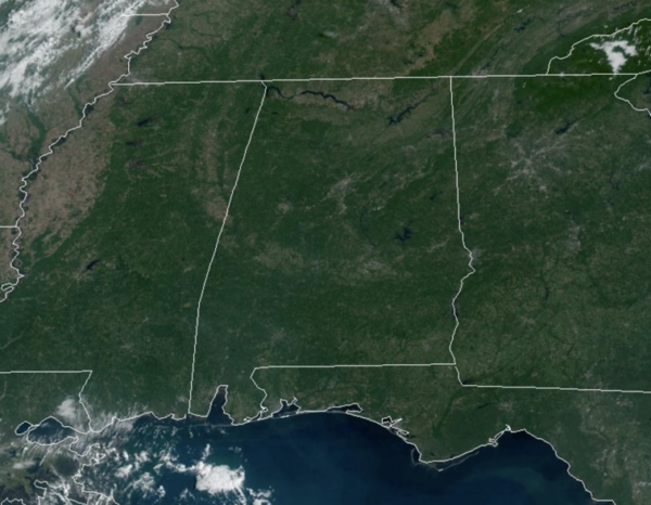
FINAL DAYS OF SUMMER: Today through Sunday, little change in the day to day forecast with plenty of sunshine and very warm temperatures as highs will be in the upper 80s and lower 90s expected. For the first time in a while, the weekend will be totally dry for North and Central Alabama. Lows will remain comfortable with widespread soothing 60s.
FRIDAY NIGHT LIGHTS: The sky will be clear for the high school games across the state tonight with temperatures falling into the 70s.
BIRMINGHAM ALMANAC: For September 20th, the average high for Birmingham is 85° and the average low is 64°. The record high is 100° set in 1925, while the record low is 46° set in 1918. We average 0.12” of precipitation on this date, and the record value is 3.49” set in 2011.
FOOTBALL WEATHER: Tomorrow, Auburn hosts Arkansas (2:30p CT kickoff) at Jordan-hare Stadium. The sky will be sunny with temperatures in the 87-90 degree range during most of the game.
Jacksonville State hosts Southern Miss (2:00p CT kickoff) at AmFirst Stadium… expect a sunny sky with temperatures in the upper 80s.
Troy hosts Florida A&M tomorrow evening (6:00p CT kickoff)… the sky will be clear; about 85 degrees at kickoff, mid 70s by the final whistle.
FALL ARRIVES: Fall officially arrives Sunday, at 7:44 AM CDT as the Autumnal Equinox occurs. This is when the sun is directly over the equator. Though many people think the day and night are the same length that day, 12 hours a piece, and that is the case over the equator. However, our day length in Birmingham will be 12 hours 7 minutes and 21 seconds.
ACROSS THE USA: Excessive heat returns for portions of the Plains today where heat indices will likely climb above the century mark. Furthermore, warm temperatures, strong winds and dry fuels may result in rapid spread of wild fires across the western High Plains today. For the east coast, lingering storm with onshore flow will bring high surf, dangerous rip currents and coastal flooding, especially at high tide.
NEXT WEEK: A few showers are possible across the state by Tuesday or Wednesday ahead of a surface front, but moisture looks limited and for now it doesn’t look like the rain will be especially heavy. Highs will be mostly in the 80s through the week. For the second half of the week, we will have to keep an eye on the Caribbean and Gulf of Mexico for potential tropical mischief, which could bring changes to our forecast for later next week.
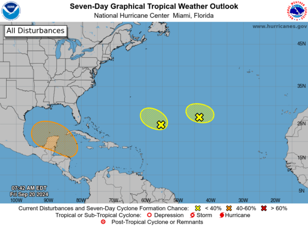
IN THE TROPICS: We still have the remnants of Gordon out in the Eastern Atlantic, but redevelopment is looking less likely. Also, another area of unsettled weather in the Central Atlantic has a low chance of development.
Closer to home, all eyes will be looking south next week as a broad area of low pressure could form by the early to middle part of next week over the northwestern Caribbean Sea. Thereafter, gradual development of this system is possible, and a tropical depression could form as the system moves slowly to the north or northwest over the northwestern Caribbean Sea and into the southern Gulf of Mexico through the end of next week. Formation chance through 7 days…medium…40 percent.
As this drifts into the southern Gulf of Mexico next week, we are expecting some sort of tropical system and there is no skill in forecasting the placement or intensity of a tropical cyclone more than 7 days in advance. The range of possibilities extends from the coast of Mexico all the way over to Florida. It could be a hurricane, or just a broad low/rainmaker. It is simply too early to know; we will begin to have some clarity late in the weekend. If you have a trip beach planned, there is absolutely no need to cancel; just keep an eye on tropical updates.
WORLD TEMPERATURE EXTREMES: Over the last 24 hours, the highest observation outside the U.S. was 119.1F at Piggs Peak, Eswatini. The lowest observation was -94.0F at Amundsen-Scott South Pole Station, Antarctica.
CONTIGUOUS TEMPERATURE EXTREMES: Over the last 24 hours, the highest observation was 109F at Rio Grande Village, TX. The lowest observation was 17F at Grand Lake, CO.
Category: Alabama's Weather, ALL POSTS, Social Media


