Monday Afternoon Update on Potential Tropical Cyclone Eight: Historic Rain for Parts of Coastal North Carolina
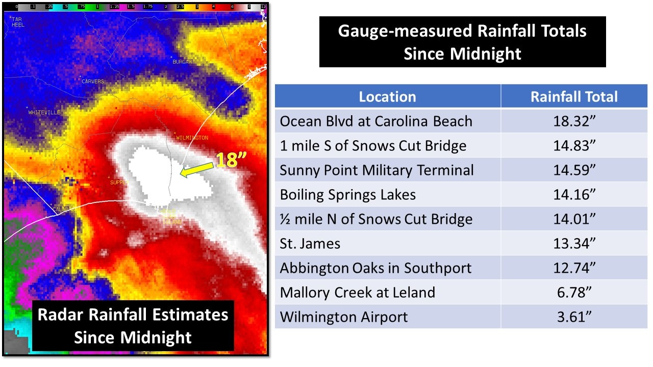
It has been a record-setting day across parts of of the North Carolina Coast with massive, life-threatening flooding. Folks, sometimes you don’t need what seems like an truly organized system, or a named system. You just need the right ingredients to come together to cause a major event. In this case, the weak low essentially produced feeder bands that trained over the same area and dumped high rain amounts over a few areas. Most of this rain came in about a 12-hour period. NWS Wilmington had the following graphic on their X Account and also the following statement. “NOAA Atlas 14 shows 12″/12 hr occurs, on average, once every 200 years. 18″/12hr is once every 1000 years!”
Below are just a few of the scenes across the NC Coast:
Wild #flashflood ongoing in #carolinabeach and around SE #NorthCarolina #PTC8 @NWSWilmingtonNC pic.twitter.com/PeYsXqTRWW
— Jonathan Petramala (@jpetramala) September 16, 2024
More from Carolina Beach with this “no name” storm.
Photos: Jen Mihalkanin pic.twitter.com/VE6LEaA8zg
— Tim Buckley (@TimBuckleyWX) September 16, 2024
Photos shared by Ryland Matthews from near the US Highway 17 intersection with NC Highway 87 in Brunswick County. Never drive around barricades, and please do not drive through flooded roads. #ncwx #PTC8 pic.twitter.com/nwmMG97DOq
— NWS Wilmington, NC (@NWSWilmingtonNC) September 16, 2024
The NHC 4pm CDT update states that this system never has formed a well-defined center and organization to be categorized as a tropical cyclone. The system is slowly moving inland is expected to dissipate quickly over the Carolinas. This will be the last public advisory from NHC and additional updates will come from the local NWS offices.
Category: ALL POSTS, Social Media, Tropical
About the Author (Author Profile)
Owner of Tornado Talk. Radio broadcast meteorologist with The Storm Report. WeatherBrains Panelist. B.S. Meteorology from Penn State University.Subscribe
If you enjoyed this article, subscribe to receive more just like it.


