Potential Tropical Cyclone Eight Forms, Moving Toward Carolinas, Will Bring Heavy Rain and Coastal Flooding
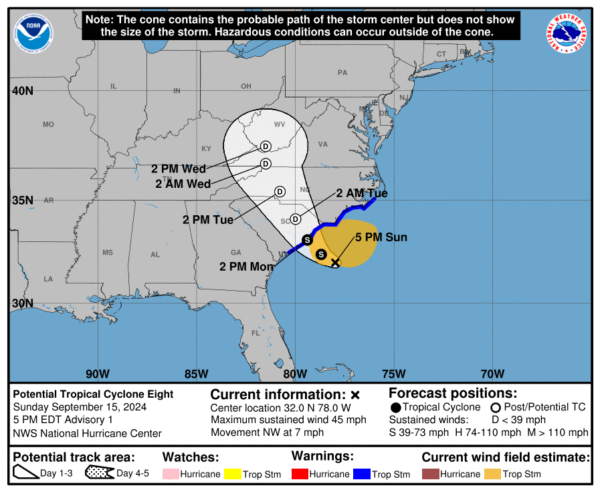
Potential Tropical Cyclone Eight has formed approximately 125 miles east-southeast of Charleston, South Carolina, and is moving northwestward at 7 mph. Currently, the system is producing maximum sustained winds of 45 mph, with higher gusts, as it approaches the coast.
It is expected to develop into a tropical or subtropical storm within the next 24 hours, before making landfall somewhere between South Carolina and North Carolina on Monday.
A tropical storm warning is in effect from Edisto Beach, South Carolina, to Ocracoke Inlet, North Carolina, as tropical-storm-force winds are forecast to arrive tonight and continue through tomorrow.
The system’s structure remains broad, with its low-level circulation still somewhat disorganized, but reports from the Air Force Hurricane Hunter aircraft indicate the storm could be consolidating closer to the mid-level circulation seen on Wilmington radar. Although it has not fully shed its frontal characteristics yet, deep convection around the center suggests that further organization into a tropical or subtropical cyclone is likely before landfall. The system is moving over warm Gulf Stream waters and remains in an environment with relatively low wind shear, which may allow for some strengthening in the next 12-24 hours before the storm moves inland.
Rainfall is expected to be one of the system’s major impacts. Forecast models indicate the potential for 3-6 inches of rain across northeastern South Carolina and eastern North Carolina, with isolated totals up to 8 inches possible. This could lead to scattered flash flooding and urban flooding in these areas. Coastal flooding is also a concern, with storm surge heights expected to reach 1-3 feet above ground along the coastlines from the South Santee River in South Carolina to Oregon Inlet, North Carolina, and in the Neuse, Bay, Pamlico, and Pungo rivers in North Carolina. These water rises will be exacerbated by large, dangerous waves, particularly near the center of the storm’s landfall.
Additionally, strong rip currents and life-threatening surf conditions are anticipated along the southeastern U.S. coastline, particularly in areas near and to the east of where the center comes ashore. A couple of tornadoes may also develop on Monday in association with the system, particularly across eastern North Carolina.
After landfall, the system is expected to weaken rapidly as it moves further inland, transitioning into a post-tropical system by Tuesday. Winds will gradually decrease, but heavy rain and flooding concerns will continue into the mid-Atlantic states, particularly Virginia, where 2-4 inches of rain are forecast, with isolated totals up to 6 inches. The system is expected to dissipate by mid-week as it moves across the Appalachians.
Residents along the southeastern coast, particularly in the warned areas, should closely monitor updates and prepare for the impacts of tropical storm-force winds, flooding, and dangerous coastal conditions.
Category: ALL POSTS, Social Media, Tropical


