Fewer Showers, Warmer/Drier Days Ahead for Alabama; but Eyes on the Tropics
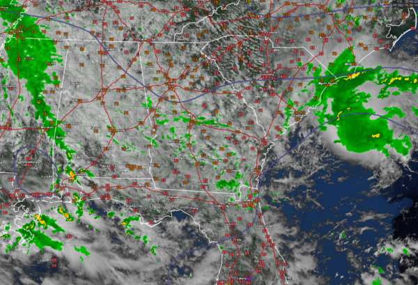
Satellite imagery this afternoon shows the northern two thirds of Alabama essentially socked in with clouds. There are a few breaks in the clouds over Northeast Alabama over Jackson and DeKalb counties. I still expect a few breaks over the rest ofteh area as we go into the late afternoon, but don’t hold your breath wherever you are.
Temperatures are in the 70s generally except at Huntsville and Demopolis.
Regional radars are pretty quiet, with most of the activity over Mississippi at this time. There are scattered light to moderate showers over East Central Alabama from Sylacauga to Lafayette to Auburn to Troy and Montgomery.
Heavier rain is over Southwest Alabama where skies have been sunnier. This activity extends from northern Mobile and Baldwin counties up into Clarke County.
To the east, your eyes are probably drawn to the activity about 150 miles off the South Carolina Coast. That is Invest 95L. Airforce Hurricane Hunters have found something of a center. The pressure was 1009 millibars and winds on the inbound were just under 40 knots. Surface wind gust estimates were near 50 knots.
The apparent center is visible from the Charleston Radar. It seems to be essentially stationary, perhaps drifting to the north.
The system has about 18-24 hours to strengthen before it moves inland. Here are some model outputs…
…HAFS-B: landfall 10 pm CDT Monday night north of Wilmington NC, 1000 mb, 39 knots
…HAFS-B: landfall 7 pm CDT Monday night near Wilmington, 993 mb, 50 knots
…HWRF: landfall 4 a.m. CDT Tuesday, near Surf City NC, 1003 mb, 40 knots
…Euro is slower…landfall 10 am Tuesday…near Wilmington…1007 mb…winds less than 30 knots
…ICON…near Surf City NC around 1 am CDT Tuesday…1005 mb…winds less than 30 knots
…GFS…Grand Strand in South Carolina…around 3 a.m. Tuesday…1000 mb….36-40 knots
Still some chance it will become Helene.
FORECAST NOTES
No big changes to the forecast. The shower chances for Tuesday look like they will be over Southwest or South Alabama.
VOODOO TROPICAL
The last 3 runs of the GFS have been consistent in depicting a weak tropical system in the western Caribbean which is consistent with the Madden Julian Oscillation phase expected at that time. The same 3 runs have also been consistent in taking it northeast across Cuba and out into the Atlantic.
Category: Alabama's Weather, ALL POSTS, Severe Weather, Social Media, Tropical


