
Additional Flash Flooding Concerns for Northwest/North Central Alabama…and Serious Flash Flooding Ongoing in Houston/Henry Counties in Southeast Alabama
The WPC is monitoring the potential for more heavy rain across North and Southeast Alabama late tonight. We have been talking about the new round of heavy rain and cooling cloud tops over Northwest and North Central Alabama late tonight. They cover that in the first discussion below.
Also, a serious flooding situation is underway in Southeast Alabama’s Houston and Henry counties where 7-9 inches of rain have fallen since yesterday. Law enforcement reports flooding is underway in Headland.
In addition, moderate rain is moving back into Eufaula, where over 7 inches of rain fell earlier on Saturday. Flash flooding could begin again at any time.
The blog will not be staffed continuously overnight. Weather checks will be made at 3 and 6 am and it will be regularly manned after 830 am. Make sure you have multiple ways of receiving warnings overnight.
Good night!
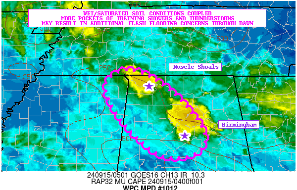
Mesoscale Precipitation Discussion 1012
NWS Weather Prediction Center College Park MD
106 AM EDT Sun Sep 15 2024
Areas affected…Central to Northwest AL…Far Northeast MS
Concerning…Heavy rainfall…Flash flooding possible
Valid 150505Z – 151105Z
SUMMARY…Heavy showers and thunderstorms are expected to impact
areas of central to northwest AL and possibly far northeast MS
going through dawn. Given the wet and locally saturated soil
conditions, the additional rains going through dawn may result in
some additional concerns for flash flooding.
DISCUSSION…The latest GOES-E IR satellite imagery shows a couple
of regional pockets of cooling convective cloud tops in
association with a broken axis of showers and thunderstorms
advancing southeast to northwest across areas of central to
northwest AL. The convection continues to focus around a broad
cyclonic circulation persisting over the Mid-South with an axis of
persistent moisture convergence and modest instability in place.
MUCAPE values are on the order of 250 to 500+ J/kg.
Rainfall rates have been seen increasing a bit over the last 1 to
2 hours with some of the convection that has been coming through
the Birmingham metropolitan area, and similar increases in
rainfall rates have been noted just west and south of Muscle
Shoals. The rates have locally increased to around 1 inch/hour and
there has been some additional cell-training concerns noted with
both the satellite and radar trends.
Notable differences exist in the 00Z HREF guidance with the
placement of the additional heavy rainfall threat overnight, but
the satellite and radar trends would suggest areas of central to
northwest AL, and perhaps far northeast MS will likely be the
primary corridor for the heaviest additional rainfall threat.
Given some of the cloud-top cooling and cell-training concerns,
additional rainfall totals going through dawn may reach as high as
2 to 3+ inches.
Given the wet and locally saturated soil conditions, these rains
may result in some additional flash flooding concerns going
through dawn.
Orrison
AWUS01 KWNH 150219
FFGMPD
FLZ000-GAZ000-ALZ000-150816-
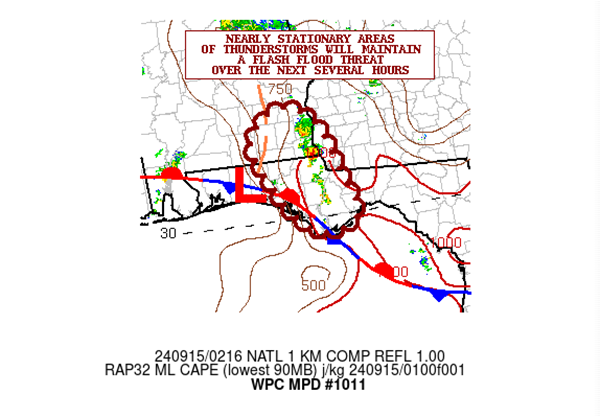
Mesoscale Precipitation Discussion 1011
NWS Weather Prediction Center College Park MD
1018 PM EDT Sat Sep 14 2024
Areas affected…Far Southeast AL…Extreme Southwest
GA…Portions of the FL Panhandle
Concerning…Heavy rainfall…Flash flooding likely
Valid 150216Z – 150816Z
SUMMARY…Locally extreme rainfall rates associated with areas of
nearly stationary thunderstorms over far southeast AL, extreme
southwest GA and portions of the FL Panhandle will likely continue
over the next several hours. Additional areas of flash flooding
are likely, and locally considerable pockets of flash flooding
will be possible.
DISCUSSION…The latest radar imagery shows areas of nearly
stationary thunderstorms over far southeast AL and portions of the
FL Panhandle. The convection is associated with an axis of
relatively focused moisture convergence situated near a front and
wave of low pressure which is coinciding with the nose of moderate
instability characterized by MLCAPE values of 1000 to 1500 J/kg.
There is also a belt of stronger mid-level west-northwest flow
aloft crossing the region which is yielding as much as 30 to 40
kts of effective bulk shear.
PWs are on the order of 1.8 to 2.0 inches and this coupled with
the instability and shear magnitudes has already been yielding
rainfall rates as high as 2 to 3 inches/hour, and some sustenance
of these rates are expected over at least the next few hours given
expectations of the environment remaining conducive for convection
to persist, at least going through the 06Z time frame.
Recent HRRR runs are quite aggressive with the rainfall totals
over the next few hours with as much as 3 to 6+ inches of
additional rain forecast going through 06Z. Given the slow
cell-motions and wet antecedent conditions, these additional rains
are likely to result in additional areas of flash flooding, some
which may be capable of producing considerable impacts.
Orrison
…Please see www.wpc.ncep.noaa.gov for graphic product…
ATTN…WFO…BMX…MOB…TAE…
ATTN…RFC…SERFC…NWC…
LAT…LON 31858561 31548502 30778469 30068444 29778469
29788528 30318580 31198627 31668603
Category: Alabama's Weather, ALL POSTS, Severe Weather, Social Media
About the Author (Author Profile)
Bill Murray is the President of The Weather Factory. He is the site's official weather historian and a weekend forecaster. He also anchors the site's severe weather coverage. Bill Murray is the proud holder of National Weather Association Digital Seal #0001 @wxhistorianSubscribe
If you enjoyed this article, subscribe to receive more just like it.


