
As Expected, the Flash Flood Watch Has Been Extended til Sunday Morning for the Tennessee Valley
The NWS has extended the flash flood watch to continue until tomorrow morning at 7 a.m.
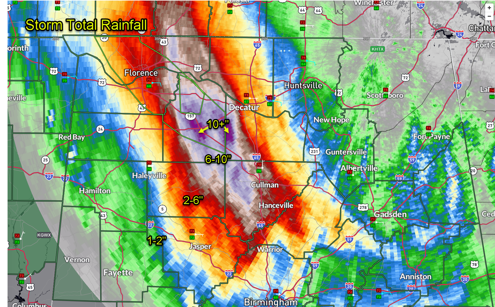
Moderate to heavy rain continues across the western Tennessee Valley tonight.
This is falling on already saturated ground in place. Rainfall totals off the Huntsville Doppler radar are impressive.
URGENT – IMMEDIATE BROADCAST REQUESTED
Flood Watch
National Weather Service Huntsville AL
637 PM CDT Sat Sep 14 2024
ALZ001>008-016-151200-
/O.EXT.KHUN.FA.A.0003.000000T0000Z-240915T1200Z/
/00000.0.ER.000000T0000Z.000000T0000Z.000000T0000Z.OO/
Lauderdale-Colbert-Franklin AL-Lawrence-Limestone-Madison-Morgan-
Marshall-Cullman-
Including the cities of Guntersville, Sheffield, Town Creek,
Cullman, Tuscumbia, Arab, Albertville, Moulton, Huntsville, Red
Bay, Decatur, Russellville, Athens, Muscle Shoals, Florence, and
Boaz
637 PM CDT Sat Sep 14 2024
…FLOOD WATCH NOW IN EFFECT THROUGH SUNDAY MORNING…
* WHAT…Flash flooding caused by excessive rainfall continues to be
possible.
* WHERE…Portions of north central, northeast, and northwest
Alabama, including the following areas, in north central Alabama,
Cullman, Limestone, Madison and Morgan. In northeast Alabama,
Marshall. In northwest Alabama, Colbert, Franklin AL, Lauderdale
and Lawrence.
* WHEN…Through Sunday morning.
* IMPACTS…Excessive runoff may result in flooding of rivers,
creeks, streams, and other low-lying and flood-prone locations.
Creeks and streams may rise out of their banks. Low-water
crossings may be flooded.
* ADDITIONAL DETAILS…
– Periods of steady rain, some moderate to heavy at times,
remain possible this evening. Rainfall totals for this event
have reached 3 to 6 inches for much of northwest Alabama west
of I-65. In a few areas in Lauderdale, Lawrence, Colbert,
Morgan and Cullman Counties, as much as 6 to 11 inches have
been observed. Additional rainfall of 1 to 2 inches could
produce additional localized flash flooding or exacerbate
ongoing areal flooding.
– http://www.weather.gov/safety/flood
PRECAUTIONARY/PREPAREDNESS ACTIONS…
You should monitor later forecasts and be prepared to take action
should Flash Flood Warnings be issued.
Category: Alabama's Weather, ALL POSTS, Severe Weather, Social Media
About the Author (Author Profile)
Bill Murray is the President of The Weather Factory. He is the site's official weather historian and a weekend forecaster. He also anchors the site's severe weather coverage. Bill Murray is the proud holder of National Weather Association Digital Seal #0001 @wxhistorianSubscribe
If you enjoyed this article, subscribe to receive more just like it.


