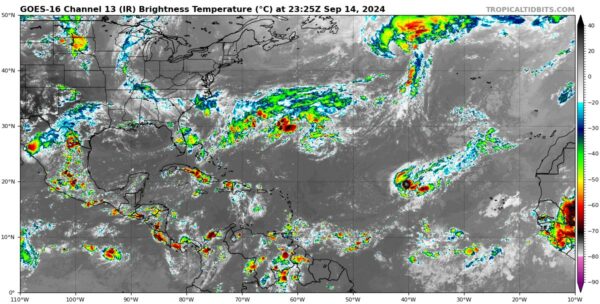
A Saturday Evening Update on the Tropics
Tropical Storm Gordon is currently positioned at 20.3N and 42.9W with maximum sustained winds of 40 knots (45 mph). Recent satellite imagery shows a slight improvement in its structure, with bursts of convection closer to the center. However, Gordon remains under the influence of unfavorable conditions, including moderate vertical wind shear and a dry, stable airmass. These factors are expected to limit its strength, and the storm is forecast to weaken to a tropical depression by Sunday.
The official forecast maintains Gordon as a tropical cyclone for now, but there is a growing possibility that it could degenerate into a remnant low or surface trough by the middle of next week. Gordon is moving westward at about 9 knots and is expected to gradually shift west-southwest while slowing down. By the middle of the week, the system is forecast to make a slow northward turn as a trough weakens the ridge steering it westward.
Elsewhere in the tropics, a low-pressure system continues to organize off the Southeastern U.S. coast, with the potential for subtropical or tropical development over the next few days. Currently, both short-term (48 hours) and longer-term (7 days) formation chances are set at 50%. This system is associated with a decaying frontal boundary and is positioned over the warm waters of the Gulf Stream, which could facilitate its transition into a tropical system as early as Sunday.
The low is expected to track northwestward toward the South and North Carolina coasts, with impacts from this system anticipated to begin late this weekend and continue into early next week. Whether or not the system fully transitions into a tropical storm, coastal residents can expect heavy rainfall, rough seas, coastal flooding, and dangerous rip currents. The GFS model has suggested this system could intensify, potentially becoming a named storm by Monday. Residents along the Carolina coastlines should monitor the latest forecasts, where conditions could worsen quickly.
Looking further ahead, another area of interest appears to be the Western Caribbean in the week two voodoo period. A more favorable atmospheric environment could develop during the week of September 23, enhancing the potential for tropical activity in that region. While details are still uncertain, some long-range models are hinting at tropical development during this period.
Category: ALL POSTS, Social Media, Tropical


