
Sunday Weather Briefing Video: Flash Flood Threat Continues Though This Morning
Hurricane Francine has delivered some drought busting rains to parts of Alabama. A little too much in some spots, for sure. And it brought damaging winds to Blount County Friday evening. Along with thousands of trees that fell in the gradient winds from the storm. Scattered showers should continue today. Let’s dig into the rest of the forecast.
SYNOPSIS
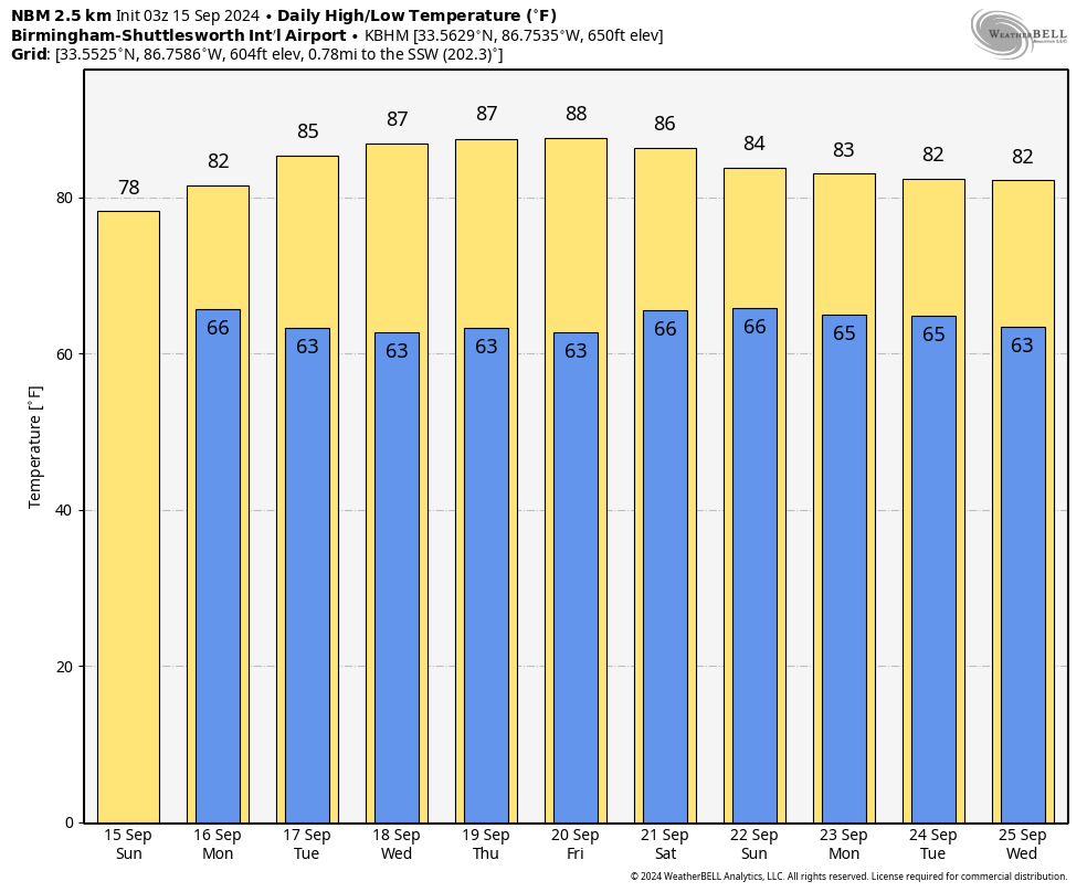
As we wrap up the weekend, the remnants of Hurricane Francine continue to influence the weather across Alabama. The system, now a weak low-pressure area near Greenwood, Mississippi, is keeping showers and storms in place for much of Central Alabama. Flash flood watches remain in effect through early on this Sunday morning and may be extended for parts of today, as additional heavy rainfall in already saturated areas could lead to localized flooding. As Francine finally moves out of the region on Monday, we’ll begin to see a break from the rain and a transition to drier, more stable conditions by midweek. A period of quiet, warm weather is expected for the second half of the week, with sunny skies and more seasonable temperatures returning.
WET START (SUNDAY THROUGH MONDAY NIGHT)
Showers will persist on Sunday as moisture continues to stream in from the southeast. Expect patchy fog in the morning and rain throughout the day, with isolated thunderstorms possible. Winds will be breezy, with gusts up to 25 mph. By Sunday night, the rain will taper off, though scattered showers will remain possible into Monday. Highs will stay cool, in the mid-70s on Sunday and warming to the low 80s by Monday afternoon. Monday night will be partly cloudy with lows dipping into the lower 60s.
DRY AND WARMER (TUESDAY THROUGH FRIDAY)
Tuesday will mark the beginning of a drier and sunnier stretch, as high pressure builds in behind the departing low. Expect mostly sunny skies and highs in the mid-80s from Tuesday through Friday, with lows in the lower 60s. Winds will remain light and out of the east, and there is little to no chance of rain during this period. This break from the rain will bring much-needed relief to waterlogged areas.
WEEKEND OUTLOOK
By the upcoming weekend, conditions will remain favorable with plenty of sunshine expected. Highs will be in the mid-80s, with comfortable lows in the lower 60s. The pleasant weather should hold through Saturday, making it a perfect weekend for outdoor activities across Central Alabama. Whether you’re attending a college football game or enjoying the outdoors, expect calm and dry conditions to prevail.
VOODOO TERRITORY (SEPTEMBER 22-28)
The GFS shows a frontal system approaching the area around midweek, Wednesday the 25th and Thursday the 26th, bring a round of showers and storms to Alabama. The GFS also hints at a possible increase in tropical activity in the Western Caribbean during that week, but it is too early to figure that out.
BEACH FORECAST
If you’re heading to the beautiful beaches of Alabama and Northwest Florida this week, the weather along the Gulf Coast will be relatively calm. Showers and storms are a pretty good bet though Monday night. Rip currents remain at a low risk, and surf heights will stay around 1 foot. However, scattered showers and thunderstorms are possible, particularly in the afternoon hours. By midweek, beach conditions improve, with sunny skies and highs in the low 80s. Just be cautious if storms develop and move indoors if necessary.
TROPICAL WEATHER UPDATE
Tropical Storm Gordon, currently about 1300 miles west-northwest of the Cabo Verde Islands, is expected to weaken into a tropical depression this morning. The storm remains under the influence of moderate wind shear and dry air, which will continue to hinder its development. Gordon is forecast to continue its westward track before turning west-southwest and potentially degenerating into a remnant low by midweek. Meanwhile, off the southeastern U.S. coast, a low-pressure system has a 50% chance of developing into a tropical storm over the next few days. This system could impact the Carolinas by Monday, with heavy rain, coastal flooding, and rough seas expected.
DAMAGING WIND EVENT IN BLOUNT COUNTY
On Friday evening, a damaging wind event impacted Blount County near Locust Fork. Straight-line winds of 50-60 mph downed trees and power lines across a broad area. It started at 6:24 p.m. and ended at 6:31 p.m. Fortunately, no injuries were reported. The National Weather Service confirmed that this event was caused by widespread straight-line winds rather than a tornado, but it still resulted in several uprooted trees, damage to homes and vehicles, and power outages.
DANCING WITH THE STATS
Birmingham’s weather on September 14, 2024, was near normal, with a high of just 74°F, well below the normal 87°F for this time of year. The rainfall total for the day was 2.32 inches, a little under an inch under the daily record of 3.22 set in 1900. This brings the month-to-date total to 3.17 inches, which is 1.21 inches above normal. For the year, Birmingham has recorded 37.83 inches of rain, still 4.31 inches below the average for this time. I recorded 3.15 inches just off Acton Road in Vestavia. My storm total is 3.70 inches. Not a bad forecast after all!
WEATHERBRAINS EPISODE UPDATE
In the latest episode of WeatherBrains, we were joined by Luke Dorris, who discussed the unique meteorological challenges of forecasting for KC, for South Florida, and about the impacts of volcanoes on this hurricane season. We also took a deep dive into hurricane dynamics and trends. If you missed it, catch up on the episode for some valuable insights into tropical weather forecasting. Check us out at www.weatherbrains.com. And get the audio version wherever you get your podcast.
ON THIS DATE IN 20024: Hurricane Ivan was approaching the Alabama coast as a powerful Category 4 storm with maximum sustained winds of 135 mph. The massive hurricane was generating destructive storm surges, flooding rains, and widespread tornado outbreaks as it neared landfall. Coastal communities from Grand Isle, Louisiana to Apalachicola, Florida were bracing for impact, with mandatory evacuations in place along the Alabama coast, where State Troopers had implemented contraflow on I-65. Ivan’s enormous size and slow forward speed contributed to prolonged periods of hurricane-force winds, storm surge flooding, and significant coastal erosion. The storm would make landfall around 2 a.m. on September 16, leaving a lasting impact on Alabama and the Gulf Coast.
Category: Alabama's Weather, ALL POSTS, Social Media, Tropical
About the Author (Author Profile)
Bill Murray is the President of The Weather Factory. He is the site's official weather historian and a weekend forecaster. He also anchors the site's severe weather coverage. Bill Murray is the proud holder of National Weather Association Digital Seal #0001 @wxhistorianSubscribe
If you enjoyed this article, subscribe to receive more just like it.


