Update From the Weather Prediction Center: Things Could Ramp Up Over the Next 3-6 Hours
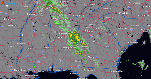
The latest mesoscale precipitation discussion has been posted by the Weather Prediction Center (WPC). Most of the heavier rain north of I-20 has become much lighter and more sporadic with the more moderate between Anniston and Auburn. That may be a-changing over the next few hours. Seeing breaks in the overcast over western into southern Alabama which will help to destabilize the atmosphere. This band of tropical moisture is poised to shift over northern Alabama. The low level circulation of what used to be Francine is still around and is situated over Northern Mississippi. Convection is expected to fire and with the tropical air mass in place, locally heavy rain may resume for areas that don’t need it or want it. Please be weather aware this afternoon. Any storms that form will not move very quickly and could dump 1-2″ of rain in an hour. We will keep you posted on the radar trends.
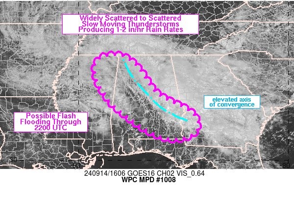
Mesoscale Precipitation Discussion 1008
NWS Weather Prediction Center College Park MD
1213 PM EDT Sat Sep 14 2024
Areas affected…northeastern MS into AL and southwestern GA
Concerning…Heavy rainfall…Flash flooding possible
Valid 141613Z – 142210Z
SUMMARY…Thunderstorms are likely to develop across northeastern
MS into AL and southwestern GA over the next 3-6 hours resulting
in possible flash flooding. Slow moving cells will likely produce
1-2 in/hr rainfall rates, which may overlap with areas that have
saturated soils.
DISCUSSION…1545Z radar imagery showed lingering rain showers
that formed along and east of an elevated convergence axis
centered near 925 mb that extended from the southern AL/GA border
into northwestern AL. Instability has lowered over northern AL
compared to earlier this morning which has allowed rainfall rates
to decrease, but small pockets of 1+ in/hr remained via MRMS
estimates from eastern AL into far southwestern GA. Visible
imagery showed the delineation between overcast skies with ongoing
showers in eastern AL and broken cloud cover to mostly clear skies
with new cumulus/shower development to the west/south over
central/southern AL into northeastern MS.
Low level easterly winds are expected to shift the boundary over
northern AL to the west through late afternoon while only slow
movement is expected to the south. Continued daytime heating
should allow weak MLCAPE values up to ~500 J/kg along the northern
MS/AL border while higher values in excess of 1000 J/kg expand
over central to southeastern AL given clearer skies as seen on
visible satellite imagery. A low to mid-level circulation tied to
former tropical cyclone Francine was located over northern MS,
allowing for a weakness in the steering flow from northwestern MS
into GA. Low level convergence is expected to redevelop a bit to
the southwest of its current position through the afternoon,
though RAP model forecasts are not as strong with the level of
convergence compared to earlier this morning. However, given the
high moisture environment and slow movement of cells atop
saturated soils across portions of the region, a couple of areas
of flash flooding may result. Expected rainfall rates of 1-2 in/hr
will likely become more numerous into the afternoon from the
northern MS/AL border into central/southeastern AL and
southwestern GA.
Category: Alabama's Weather, ALL POSTS, Severe Weather, Social Media


