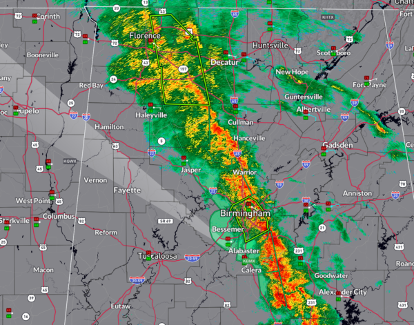
Several Counties Added to Flood Advisories: Widespread Heavy Rain Falling in Long Band
The NWS Birmingham has issued several flood advisories in the past few minutes…they go until 930-945.
One hour rainfall amounts are approaching and in some cases exceeding one inch, and radar indications may be low.
I have picked up 1.19 inches in 45 minutes off Acton Road.
THREAT: Urban and small stream flooding caused by excessive rainfall is expected. Minor flooding in low-lying and poor drainage areas.
WHERE: Portions of central Alabama, including the following counties:
… Shelby
… Chilton
… Coosa
… Blount
… Jefferson
… Walker
… Winston
WHEN: Until 9:30 AM CDT for Blount, Jefferson, Walker, and Winston counties, and until 9:45 AM CDT for Shelby, Chilton, and Coosa counties.
ADDITIONAL DETAILS:
… Doppler radar indicates heavy rain due to thunderstorms, leading to urban and small stream flooding.
… Locations expected to experience flooding include:
… Shelby County: Alabaster, Pelham, Helena, Calera, Chelsea, Columbiana, Oak Mountain State Park, Shelby, Bounds Lake, Ballantrae, Camp Branch, Saddle Lake Farms.
… Chilton, Coosa, Shelby Counties: Clanton, Lay Lake Dam, Gap of the Mountain, Lay Lake, Mitchell Lake, Higgins Ferry Park, Waxahatchee Creek, Paint Creek, I-65 Rest Area, Highway 145 and CR 46, Spring Creek.
… Blount, Jefferson, Walker, Winston Counties: Birmingham, Jasper, Gardendale, Fultondale, Sumiton, Cordova, Dora, Arley, Adamsville, Warrior, Kimberly, Graysville, Morris, Brookside, Double Springs, Mulga, Addison, Sipsey, Maytown, West Jefferson.
PRECAUTIONARY/PREPAREDNESS ACTIONS:
Turn around, don’t drown when encountering flooded roads. Most flood deaths occur in vehicles.
Be aware of your surroundings and do not drive on flooded roads.
Category: Alabama's Weather, ALL POSTS, Severe Weather, Social Media


