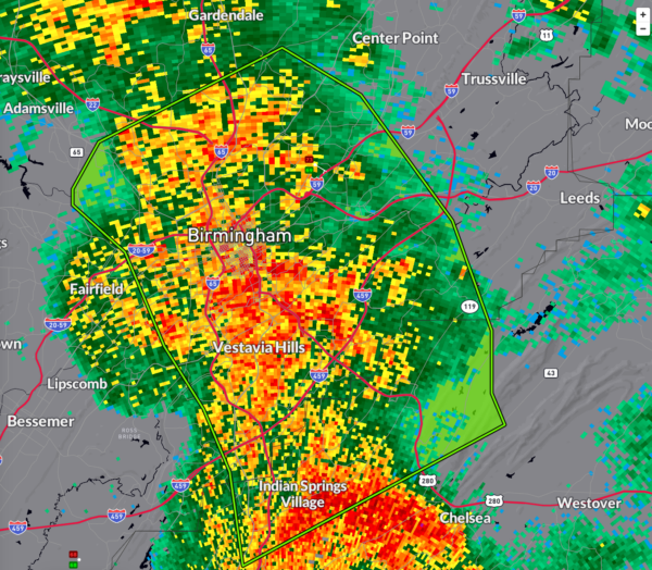
Flash Flood Warning for Birmingham Metro: Turn Around, Don’t Drown This Morning!
Known flood areas will begin to flood soon. Turn around, don’t drown!
BULLETIN – EAS ACTIVATION REQUESTED
Flash Flood Warning
National Weather Service Birmingham AL
614 AM CDT Sat Sep 14 2024
The National Weather Service in Birmingham has issued a
* Flash Flood Warning for…
Southeastern Jefferson County in central Alabama…
North Central Shelby County in central Alabama…
* Until 915 AM CDT.
* At 614 AM CDT, Doppler radar indicated thunderstorms producing
heavy rain across the warned area. Between 1 and 2 inches of rain
have fallen. Additional rainfall amounts of 2 to 4 inches are
possible in the warned area. Flash flooding is ongoing or expected
to begin shortly.
HAZARD…Flash flooding caused by thunderstorms.
SOURCE…Radar.
IMPACT…Flash flooding of small creeks and streams, urban
areas, highways, streets and underpasses as well as
other poor drainage and low-lying areas.
* Some locations that will experience flash flooding include…
Birmingham, Hoover, Vestavia Hills, Homewood, Pelham, Mountain
Brook, Gardendale, Irondale, Fultondale, Tarrant, Indian Springs
Village, Cahaba Heights, Samford University, Five Points South,
The Summit, U.A.B. Campus, Kingston, Regions Field, B.j.c.c. and
Birmingham Airport.
PRECAUTIONARY/PREPAREDNESS ACTIONS…
Turn around, don’t drown when encountering flooded roads. Most flood
deaths occur in vehicles.
Be aware of your surroundings and do not drive on flooded roads.
&&
LAT…LON 3341 8683 3345 8686 3351 8689 3354 8693
3355 8693 3358 8691 3361 8684 3364 8677
3363 8675 3361 8671 3353 8664 3346 8661
3344 8661 3342 8661 3340 8660 3331 8680
3337 8681
FLASH FLOOD…RADAR INDICATED
Category: Alabama's Weather, ALL POSTS, Severe Weather, Social Media


