Weather Briefing Video — More and More Rain Through the Weekend; Drier Weather Starting on Tuesday
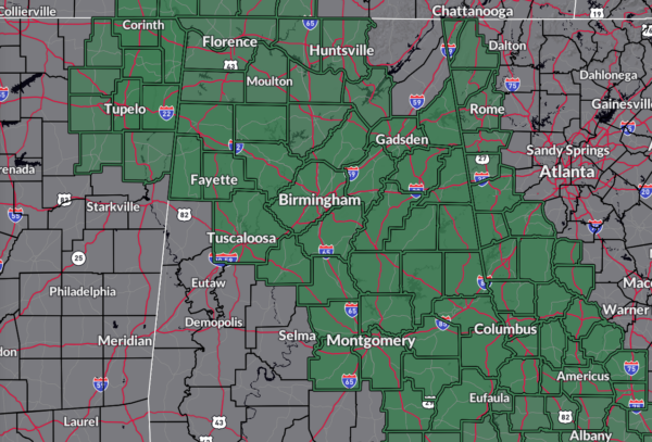
A Flood Watch is in effect until Sunday morning for most of North Alabama, except the easternmost counties, and for much of Central Alabama, excluding the southwestern counties. Some areas could see 2–4 inches of rain, while other parts might get an inch or less by tomorrow evening. Rain rates are expected to increase as it warms up and becomes more unstable. Rain is likely north of a line from Hamilton to Clanton to Eufaula, but chances drop as you move southwest. Despite the cloud cover and rain keeping temperatures in the mid 70s to mid 80s, severe weather isn’t expected today. On Sunday, rain and storms will continue. Rain is likely in the central and eastern parts of the area, and very likely in the western parts of Central Alabama. Heavy rain is possible, but no severe weather is expected. Highs will be in the mid to upper 70s.
Monday will see the remnants of Francine causing ongoing rain and thunderstorms, with heavy rain possible but no severe weather expected. Highs will be in the upper 70s to lower 80s. A trough will push a surface front through Central Alabama on Tuesday, bringing drier air from the north. Only a slight chance of isolated showers and storms is expected, with highs in the lower to mid 80s. Wednesday will be mainly sunny and dry due to a northerly flow, with highs in the lower to mid 80s. Thursday will also be sunny and warm, with temperatures reaching the mid to upper 80s. And, at the end of the forecast period, sunny skies prevail with highs in the mid to upper 80s.
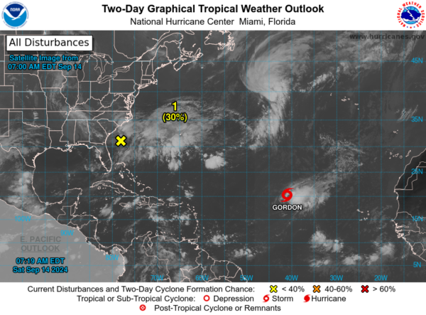
Looking ahead to the tropics, a new low-pressure system is expected to form this weekend a few hundred miles offshore from the Southeastern U.S. It could develop subtropical or tropical characteristics as it moves over the warm waters of the Gulf Stream. By early next week, it might become a subtropical or tropical depression or storm as it heads northwest toward the coast. There’s a 30% chance this system will form in the next 48 hours, increasing to 50% over the next 7 days.
Tropical Storm Gordon is moving west-northwest at about 9 mph (15 km/h) over the open ocean. It may slow down and shift direction over the next few days. Gordon currently has maximum sustained winds of 45 mph, with stronger gusts. It is expected to weaken and become a depression by early Sunday, but it might start to strengthen again by midweek.
Category: Alabama's Weather, ALL POSTS, Social Media, Tropical, Weather Xtreme Videos


