Flood Advisories for the Birmingham Metro
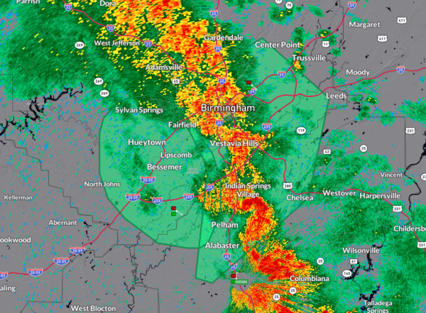
A large band of very heavy rain is rotating slowly northeast through the Birmingham Metro area at this hour, prompting flood advisories for much of the Metro.
It is raining heavily between I-22 and I-65 through much of Birmingham into Mountain Brooke, Homewood, Vestavia, Hoover, and into northern Shelby County.
The band extends Athens, Decatur, and Moulton in North Alabama through Walker County to Birmingham though Sherlby and Chilton Counties mainly east of I-65 and then back to near Prattville and Montgomery.
There is also a flash flood advisory along US-82 from Maplesville and Billingsley back to Prattville.
Rainfall rates in the band are approaching one inch per hour.
Be careful if you’re heading out this morning. Be alert for water on roadways, and always remember, Turn Around, Don’t Drown.
Convection allowing models like the HRRR predict that the band will sort of meander back and forth over the are through the day. This could of course lead to some heavy rainfall amounts and potential flooding.
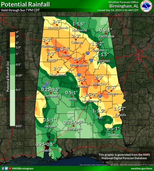
Potential rainfall looks like this…
This could cause more flooding.
Here is the text of a discussion from the Weather Prediction Center:
Mesoscale Precipitation Discussion 1007
NWS Weather Prediction Center College Park MD
600 AM EDT Sat Sep 14 2024
Areas affected…Western and Middle TN…Far Northeast
MS…Northwest to Southeast AL…Southwest to Central GA
Concerning…Heavy rainfall…Flash flooding possible
Valid 141000Z – 141600Z
SUMMARY…Locally slow-moving and occasionally training bands of
heavy showers and thunderstorms is expected to maintain a threat
for some areas of flash flooding going through the morning hours.
DISCUSSION…Generally there has not been much change over the
last several hours to setup and character of the heavy rainfall
threat that continues to impact areas of the Mid-South. The latest
GOES-E IR satellite imagery coupled with dual-pol radar continues
to show some broken bands of showers and occasionally some
thunderstorms across portions of western and middle TN down
through much of northwest and central AL. Some weaker and more
disorganized convection is seen over parts of southeast AL. This
is all in association with what is left of Post-T.C. Francine.
There continues to be an axis of persistent moisture convergence
and modest instability oriented in a north-northwest to
south-southeast fashion across the region, with MUCAPE values of
500 to 1000 J/kg and PWs of 1.75 to 2.0 inches. A very gradual
cyclonic pivoting of the convection has been occurring over the
last few hours as the ill-defined center of Post-T.C. Francine and
its frontal occlusion tends to lose latitude.
Going through the morning hours, some additional focus for broken
bands of convection should continue with some additional
likelihood for some cell-training. This will be favored by a
persistent fetch of at least modest moisture transport and
instability around the eastern flank of the weakening frontal
occlusion. Rainfall rates with the stronger convective cores may
reach 1 to 1.5 inches/hour this morning and this is consistent
with the 00Z/06Z HREF guidance. Recent HRRR runs suggest that
there could be some potential for convection to develop and
perhaps become locally a bit more concentrated farther down to the
south and east across areas of southeast AL and into parts of
southwest to central GA but there is more model spread overall
with the details of this.
Some additional spotty rainfall totals this morning of 2 to 4
inches will be possible where any additional cell-training occurs,
and given the wet antecedent conditions across most of the region,
this may foster some additional runoff concerns and possible flash
flooding.
Orrison
…Please see www.wpc.ncep.noaa.gov for graphic product…
ATTN…WFO…BMX…FFC…HUN…JAX…MEG…MOB…OHX…TAE…
ATTN…RFC…LMRFC…SERFC…NWC…
LAT…LON 36188789 35748724 34788633 33388506 32428274
31608259 31058344 31118518 31668619 33158712
34088787 34928893 35558908 36138869
Category: Alabama's Weather, ALL POSTS, Severe Weather, Social Media


